
Create successful ePaper yourself
Turn your PDF publications into a flip-book with our unique Google optimized e-Paper software.
L. D. PETERSEN, F. K. DUENNEBIER, T. H. SHIPLEY<br />
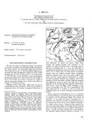
14°N<br />
156°E 157 C<br />
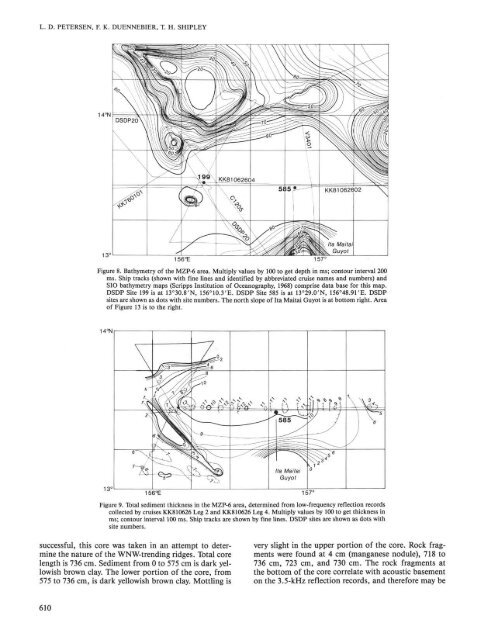
Figure 8. Bathymetry of the MZP-6 area. Multiply values by 100 to get depth in ms; contour interval 200<br />
ms. Ship tracks (shown with fine lines and identified by abbreviated cruise names and numbers) and<br />
SIO bathymetry maps (Scripps Institution of Oceanography, 1968) comprise data base for this map.<br />
DSDP Site 199 is at 13°3O.8'N, 156°1O.3'E. DSDP Site 585 is at 13°29.0'N, 156°48.91'E. DSDP<br />
sites are shown as dots with site numbers. The north slope of Ita Maitai Guyot is at bottom right. Area<br />
of Figure 13 is to the right.<br />
14°N<br />
156°E 157 C<br />
Figure 9. Total sediment thickness in the MZP-6 area, determined from low-frequency reflection records<br />
collected by cruises KK810626 Leg 2 and KK810626 Leg 4. Multiply values by 100 to get thickness in<br />
ms; contour interval 100 ms. Ship tracks are shown by fine lines. DSDP sites are shown as dots with<br />
site numbers.<br />
successful, this core was taken in an attempt to determine<br />
the nature of the WNW-trending ridges. Total core<br />
length is 736 cm. Sediment from 0 to 575 cm is dark yellowish<br />
brown clay. The lower portion of the core, from<br />
575 to 736 cm, is dark yellowish brown clay. Mottling is<br />
610<br />
very slight in the upper portion of the core. Rock fragments<br />
were found at 4 cm (manganese nodule), 718 to<br />
736 cm, 723 cm, and 730 cm. The rock fragments at<br />
the bottom of the core correlate with acoustic basement<br />
on the 3.5-kHz reflection records, and therefore may be