Create successful ePaper yourself
Turn your PDF publications into a flip-book with our unique Google optimized e-Paper software.
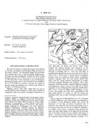
σ\<br />
15°N<br />
158°E 159 160°<br />
Figure 18. Residual-magnetism contour map of the MZP-3 region. Values in gammas; contour interval 20 gammas. Ship tracks are shown as fine lines and identified by abbreviated<br />
cruise names and numbers. Cruises from which data were not usable are identified by parentheses.