Create successful ePaper yourself
Turn your PDF publications into a flip-book with our unique Google optimized e-Paper software.
1 2°30'N<br />
11 °30'<br />
1 64°30'E 165°<br />
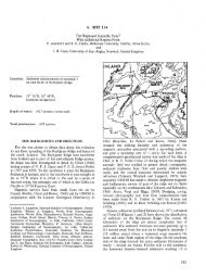
SITE SURVEYS IN THE WESTERN PACIFIC<br />
Figure 20. Bathymetry of Sylvania <strong>Sea</strong>mount. Multiply values by 100 to get depth in ms; contour interval 200 ms. Data from<br />
cruises (ship tracks shown as fine lines and identified by abbreviated cruise names and numbers) and bathymetric chart of Emery<br />
et al. (1954) make up data base for this map. Star shows location of dredge RD-67 on side of Sylvania; Bikini Atoll is at<br />
lower right.<br />
621