

Creating high-resolution hail datasets using social media and post ...
Creating high-resolution hail datasets using social media and post ...
Creating high-resolution hail datasets using social media and post ...

Create successful ePaper yourself
Turn your PDF publications into a flip-book with our unique Google optimized e-Paper software.
Eight <strong>hail</strong> stones, identified from the NWS <strong>post</strong>-storm ground survey <strong>and</strong> the search<br />
through <strong>social</strong> <strong>media</strong>-based web pages, exceeded the previous Kansas record diameter stone of<br />
144 mm (5.67 in.). The residents that discovered the Wichita stone uploaded an image of the<br />
stone to one of the local television station’s <strong>social</strong> <strong>media</strong>-based photo forums, <strong>and</strong> the station<br />
promptly shared the information with the NWS ICT during the ongoing severe weather event. It<br />
is worthy to note how important of a role such technologies served to document <strong>hail</strong>stones of this<br />
magnitude. While giant <strong>hail</strong> is a relatively rare phenomenon based on records in Storm Data, it<br />
has likely been underreported in the past (Blair et al. 2011). Table 1 reveals that the seven<br />
largest verifiable United States <strong>hail</strong>stones have occurred since 2003. Thus, it is reasonable to<br />
conclude more <strong>high</strong>-end <strong>hail</strong> events will continue to be documented as photo-sharing<br />
technologies become more widespread <strong>and</strong> utilized by the public <strong>and</strong> the meteorological<br />
community.<br />
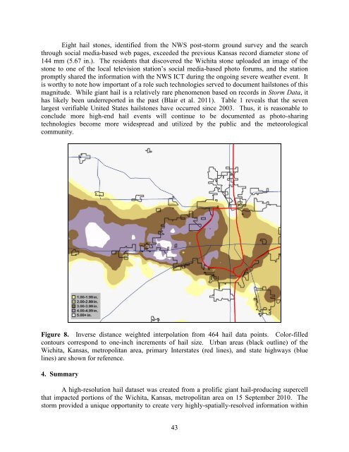
Figure 8. Inverse distance weighted interpolation from 464 <strong>hail</strong> data points. Color-filled<br />
contours correspond to one-inch increments of <strong>hail</strong> size. Urban areas (black outline) of the<br />
Wichita, Kansas, metropolitan area, primary Interstates (red lines), <strong>and</strong> state <strong>high</strong>ways (blue<br />
lines) are shown for reference.<br />
4. Summary<br />
A <strong>high</strong>-<strong>resolution</strong> <strong>hail</strong> dataset was created from a prolific giant <strong>hail</strong>-producing supercell<br />
that impacted portions of the Wichita, Kansas, metropolitan area on 15 September 2010. The<br />
storm provided a unique opportunity to create very <strong>high</strong>ly-spatially-resolved information within<br />
43


