Encom Discover v10.1 Release Notes - Pitney Bowes Software
Encom Discover v10.1 Release Notes - Pitney Bowes Software
Encom Discover v10.1 Release Notes - Pitney Bowes Software

Create successful ePaper yourself
Turn your PDF publications into a flip-book with our unique Google optimized e-Paper software.
discover version 10.1<br />
release notes<br />
advances<br />
<strong>Encom</strong>’s powerful <strong>Discover</strong> 10.1 geoscience package complements the release<br />
of MapInfo Professional ® 9.5 with a host of new Surfaces functionality, as well<br />
as extensive improvements to the Drillhole module. Many popular tools have<br />
also been redesigned to provide a more dynamic and user-friendly interface.<br />
General Improvements<br />
• Supports MapInfo Professional 9.5<br />
• Updated support for version 4.1.0.2 of the acQuire database model<br />
• 30% performance improvement in many data processing tools<br />
Surfaces<br />
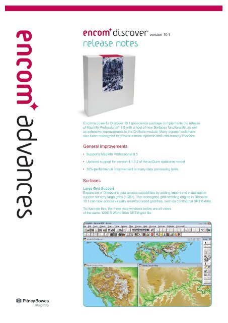
Large Grid Support<br />
Expansion of <strong>Discover</strong>’s data access capabilities by adding import and visualisation<br />
support for very large grids (1GB+). The redesigned grid handling engine in <strong>Discover</strong><br />
10.1 can now access virtually unlimited sized grid files, such as continental SRTM data.<br />
To illustrate this, the three map windows below are all views<br />
of the same 120GB World 90m SRTM grid file.
New Grid Tiler<br />
Huge grid files can now be cut into<br />
smaller tiles prior to opening in<br />
MapInfo Pro, thereby allowing them<br />
to be efficiently processed by the<br />
various Surfaces manipulation tools.<br />
Grid Utilities<br />
• New Cut/Fill tool<br />
Summarises the areas and volumes<br />
of change that have occurred<br />
between two grid surfaces.<br />
advances<br />
New Grid Profiler tool<br />
Dynamically create and interrogate<br />
profiles across one or more grids with a<br />
completely redesigned Grid Profiler tool.<br />
New Grid Format Support<br />
Support for additional grid file formats<br />
has been added such as HGT (for<br />
example NASA’s SRTM data), Landmark,<br />
Geosoft GFX, and MapInfo MIG formats.<br />
New Contour Label Positioner<br />
Creates precisely positioned and<br />
orientated contour labels using<br />
user-defined label path lines.<br />
• New Outline tool<br />
Creates attributed polygons outlining<br />
the bounds of multiple grids e.g.<br />
to visualise the extents of multiple<br />
airborne geophysical surveys.<br />
• New Surface Area tool<br />
Calculates the total 3D surface area,<br />
2D planar area and roughness of a grid.<br />
• Usability and performance<br />
improvements have also been<br />
made to the Classify, Grid to Grid<br />
Clip, Split and Vectorise utilities.<br />
Grid Filter<br />
Added an FFT Reduction to<br />
Pole (Low Latitude) filter.<br />
Data Utilities<br />
New Local Grid Layout tool<br />
New Grid Clip tool<br />
Clip grids to user-defined limits<br />
for more efficient handling and<br />
processing of very large grids.<br />
A dynamic new interface allows:<br />
• Interactive baseline or traverse<br />
line definition by drawing<br />
in mapper window.<br />
• Grid design to be previewed<br />
and modified dynamically<br />
in the mapper window.<br />
• Creation of both grid pegs<br />
(points) and grid lines.<br />
• Creation of triangular/diamond pattern<br />
grids (i.e. offset grid pegs/lines).
Drillholes<br />
New Project Setup dialog<br />
• Intuitive wizard interface<br />
• Graphic preview of the collar plan<br />
• Summary information for each project<br />
• Auto-detection down-dip of direction<br />
New Section Manager dialog<br />
Table Utilities<br />
New Unique Identifier tool<br />
Attributes every row in a table<br />
with a unique incrementing value<br />
(e.g. HGRC1021, HGRC1022...<br />
or 8433 west, 8434 west...).<br />
New Favourites dialog<br />
A new combined dialog allows the<br />
custom ordering of your favourite<br />
tables, workspaces, MBXs.<br />
New Multi Column Update tool<br />
Updating large numbers of fields<br />
is now much easier with automatic<br />
field matching (when field names<br />
are identical) and saving/loading<br />
of field assignment templates<br />
Redesigned Sort Table interface<br />
Object Editing<br />
Align Objects tool<br />
New Disperse option allows<br />
selected objects to be evenly spread<br />
between the end members, useful<br />
when aligning legend objects<br />
Geochem<br />
New Point Classification tool<br />
The size, colour and/or symbols of point<br />
data can be modulated by one or more<br />
fields (such as Cu modulated by size<br />
and rock type modulated by colour),<br />
allowing homogenous data classes to be<br />
defined by ranges or groups of values.<br />
• Dynamic auto-preview of section’s<br />
spatial extents in collar map window<br />
• Detailed listing of section parameters<br />
New Drillhole Query Tool<br />
• Calculates the maximum downhole<br />
values for each hole, including From/<br />
To depths and ancillary fields<br />
• Returns the End-of-Hole<br />
(EOH) interval for each hole<br />
(including BOH checks)<br />
New gINT Importer<br />
Imports drillhole data from the gINT<br />
borehole logging application into<br />
a <strong>Discover</strong> drillhole project.<br />
Improved Define New<br />
Section or Plan tool<br />
A number of improvements have<br />
been made, including providing<br />
user customisation of the surface<br />
line colour and easier visibility of<br />
user defined colour table names.<br />
Improved Trenching dialog<br />
Map Window<br />
The following tools have been redesigned<br />
to allow the dialogs to be kept open<br />
whilst working within MapInfo:<br />
Select by Graphical Style<br />
• Now supports differing<br />
source and target tables<br />
• New output query options<br />
Standard Views<br />
Allows customised ordering<br />
Favourite Projections<br />
Allows customised ordering<br />
Images<br />
A new Transparency control is<br />
available under the Modify tab.<br />
Improved Levelling tool<br />
Creates new output summary fields<br />
GraphMap<br />
Extensive improvements, including:<br />
• New Order column option<br />
• New batch export of graphs to MapInfo<br />
• Data Handling can be<br />
applied to multiple fields<br />
• Performance improvements.
Requirements<br />
<strong>Encom</strong> <strong>Discover</strong> 10.1 requires<br />
MapInfo Professional 8.0 to 9.5,<br />
with Windows 2000, XP or Vista.<br />
Contact <strong>Encom</strong><br />
Asia-Pacific/Australia<br />
Level 7, 1 Elizabeth Plaza<br />
North Sydney NSW 2060 Australia<br />
T + 61 2 9437 6255 F +61 2 9439 1773<br />
Level 2, 1050 Hay Street<br />
West Perth WA 6005 Australia<br />
T +61 8 9226 0101 F +61 8 9226 0102<br />
Americas<br />
26 Wellington Street East, Suite 500<br />
Toronto, Ontario M5E 1S2 Canada<br />
T +1 416 594 5200 F +1 416 594 5201<br />
Europe/United Kingdom<br />
Minton Place, Victoria Street, Windsor<br />
Berkshire SL4 1EG United Kingdom<br />
T +44 1753 848200 F +44 1753 621140<br />
discover@encom.com.au<br />
www.encom.com.au<br />
Windows Vista ® , Windows ® and Windows NT ® are registered trademarks of<br />
Microsoft Corporation. MapInfo Professional ® is a US registered trademark<br />
of <strong>Pitney</strong> <strong>Bowes</strong> <strong>Software</strong> Inc. <strong>Discover</strong> Advances Document 10.1