Tsunami evacuation: Lessons from the Great East Japan earthquake ...
Tsunami evacuation: Lessons from the Great East Japan earthquake ...
Tsunami evacuation: Lessons from the Great East Japan earthquake ...

You also want an ePaper? Increase the reach of your titles
YUMPU automatically turns print PDFs into web optimized ePapers that Google loves.
2012<br />
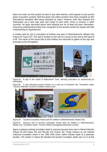
black icon used, but this symbol not seen in any o<strong>the</strong>r districts, which appear to only use <strong>the</strong><br />
green <strong>evacuation</strong> symbols. Both <strong>the</strong> green and yellow symbols have been accepted as ISO<br />
international standards after being proposed by <strong>Japan</strong>. However, both New Zealand and<br />
Washington use a blue sign style very similar to each o<strong>the</strong>r, which is common in o<strong>the</strong>r<br />
countries. All signs discussed above have bilingual text for at least <strong>the</strong> basic information,<br />
enhancing understanding fur<strong>the</strong>r than recognition of <strong>the</strong> tsunami symbol for people with little<br />
understanding of <strong>Japan</strong>ese text.<br />
A muster point for use in <strong>evacuation</strong> of children was seen in Hitachihamacho, Miyako City<br />
(Figure 26, Figure 27). This sign is located on <strong>the</strong> wall of a house on <strong>the</strong> road at <strong>the</strong> base of<br />
a hill. The owner of <strong>the</strong> house told us that children are instructed to ga<strong>the</strong>r at this sign and<br />
evacuate up <strong>the</strong> hill toge<strong>the</strong>r.<br />
Figure 24 A sign in <strong>the</strong> centre of Matsushima Town, advising <strong>evacuation</strong> on experiencing an<br />
<strong>earthquake</strong>.<br />
Figure 25 A sign indicating tsunami hazard, on a road out of Kamaishi City. Translation reads:<br />
“<strong>Tsunami</strong> Attention! <strong>Tsunami</strong> inundation hazard zone”.<br />
Figure 26 <strong>Tsunami</strong> <strong>evacuation</strong> muster point for children in Hitachihamacho, Miyako City.<br />
Figure 27 Close-up view of tsunami <strong>evacuation</strong> muster point for children in Hitachihamacho,<br />
Miyako City. Translation reads: “<strong>Tsunami</strong> shelter (Kuwagasaki elementary school)”.<br />
Signs or plaques marking inundation depth in previous tsunami were seen in Minami-Sanriku<br />
(Figure 28 and Figure 29) and Ōfunato City (Figure 30). These markers do not indicate<br />
maximum inundation extent in <strong>the</strong> 1960 Chile event; ra<strong>the</strong>r indicate depth at a particular<br />
location. The marker in Figure 28 indicates <strong>the</strong> tsunami inundation depth was 2.4 m at this<br />
GNS Science Report 2012/17 23