Tsunami evacuation: Lessons from the Great East Japan earthquake ...
Tsunami evacuation: Lessons from the Great East Japan earthquake ...
Tsunami evacuation: Lessons from the Great East Japan earthquake ...

Create successful ePaper yourself
Turn your PDF publications into a flip-book with our unique Google optimized e-Paper software.
2012<br />
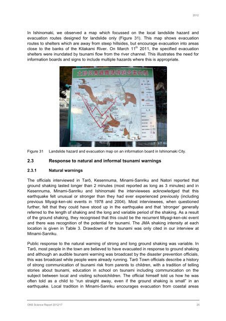
In Ishinomaki, we observed a map which focussed on <strong>the</strong> local landslide hazard and<br />
<strong>evacuation</strong> routes designed for landslide only (Figure 31). This map shows <strong>evacuation</strong><br />
routes to shelters which are away <strong>from</strong> steep hillsides, but encourage <strong>evacuation</strong> into areas<br />
close to <strong>the</strong> banks of <strong>the</strong> Kitakami River. On March 11 th 2011, <strong>the</strong> specified <strong>evacuation</strong><br />
shelters were inundated by tsunami flow <strong>from</strong> <strong>the</strong> river channel. This illustrates <strong>the</strong> need for<br />
information boards and signs to include multiple hazards where this is appropriate.<br />
Figure 31<br />
Landslide hazard and <strong>evacuation</strong> map on an information board in Ishinomaki City.<br />
2.3 Response to natural and informal tsunami warnings<br />
2.3.1 Natural warnings<br />
The officials interviewed in Tarō, Kesennuma, Minami-Sanriku and Natori reported that<br />
ground shaking lasted longer than 2 minutes (most reported as long as 3 minutes) and in<br />
Kesennuma, Minami-Sanriku and Ishinomaki <strong>the</strong> interviewees acknowledged that this<br />
<strong>earthquake</strong> felt unusual or stronger than <strong>the</strong>y had ever experienced previously (including<br />
previous Miyagi-ken-oki events in 1978 and 2004). Most interviewees, when questioned<br />
fur<strong>the</strong>r, felt that <strong>the</strong>y could have stood up in <strong>the</strong> <strong>earthquake</strong> and that ‘stronger’ generally<br />
referred to <strong>the</strong> length of shaking and <strong>the</strong> long and variable period of <strong>the</strong> shaking. As a result<br />
of <strong>the</strong> ground shaking, <strong>the</strong>y recognised that this could be <strong>the</strong> recurrent Miyagi-ken-oki event<br />
and <strong>the</strong>re was recognition of <strong>the</strong> potential for tsunami. The JMA shaking intensity at each<br />
location is given in Table 3. Drawdown of <strong>the</strong> tsunami was only cited in our interview at<br />
Minami-Sanriku.<br />
Public response to <strong>the</strong> natural warning of strong and long ground shaking was variable. In<br />
Tarō, most people in <strong>the</strong> town are believed to have evacuated in response to ground shaking<br />
and although an audible tsunami warning was broadcast by <strong>the</strong> disaster prevention officials,<br />
this was broadcast while people were already running. Tarō Town officials describe a history<br />
of strong communication of tsunami risk <strong>from</strong> parents to children, with a tradition of telling<br />
stories about tsunami, education in school on tsunami including communication on <strong>the</strong><br />
subject between local and visiting schoolchildren. The official himself told us how he was<br />
often told as a child to “run straight away, even if <strong>the</strong> ground shaking is small” in an<br />
<strong>earthquake</strong>. Local tradition in Minami-Sanriku encourages <strong>evacuation</strong> <strong>from</strong> coastal areas<br />
GNS Science Report 2012/17 25