

Application of New Pedestrian Level of Service Measures - sacog
Application of New Pedestrian Level of Service Measures - sacog
Application of New Pedestrian Level of Service Measures - sacog

Create successful ePaper yourself
Turn your PDF publications into a flip-book with our unique Google optimized e-Paper software.
<strong>Application</strong> <strong>of</strong> <strong>New</strong> <strong>Pedestrian</strong> <strong>Level</strong> <strong>of</strong> <strong>Service</strong> <strong>Measures</strong><br />
SACOG<br />
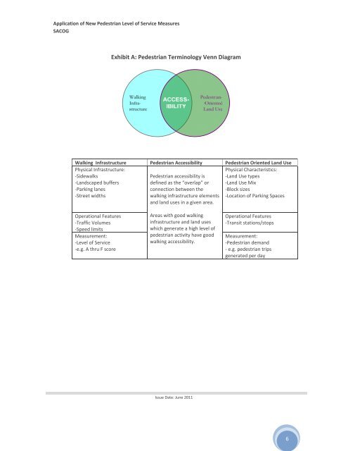
Exhibit A: <strong>Pedestrian</strong> Terminology Venn Diagram<br />
Walking Infrastructure <strong>Pedestrian</strong> Accessibility <strong>Pedestrian</strong> Oriented Land Use<br />
Physical Infrastructure:<br />
‐Sidewalks<br />
‐Landscaped buffers<br />
‐Parking lanes<br />
‐Street widths<br />
<strong>Pedestrian</strong> accessibility is<br />
defined as the “overlap” or<br />
connection between the<br />
walking infrastructure elements<br />
and land uses in a given area.<br />
Physical Characteristics:<br />
‐Land Use types<br />
‐Land Use Mix<br />
‐Block sizes<br />
‐Location <strong>of</strong> Parking Spaces<br />
Operational Features<br />
‐Traffic Volumes<br />
‐Speed limits<br />
Measurement:<br />
‐<strong>Level</strong> <strong>of</strong> <strong>Service</strong><br />
‐e.g. A thru F score<br />
Areas with good walking<br />
infrastructure and land uses<br />
which generate a high level <strong>of</strong><br />
pedestrian activity have good<br />
walking accessibility.<br />
Operational Features<br />
‐Transit stations/stops<br />
Measurement:<br />
‐<strong>Pedestrian</strong> demand<br />
‐ e.g. pedestrian trips<br />
generated per day<br />
Issue Date: June 2011<br />
6


