Wind Direction Sensor User Manual - MicroDAQ.com
Wind Direction Sensor User Manual - MicroDAQ.com
Wind Direction Sensor User Manual - MicroDAQ.com

You also want an ePaper? Increase the reach of your titles
YUMPU automatically turns print PDFs into web optimized ePapers that Google loves.
<strong>Wind</strong> <strong>Direction</strong> Smart <strong>Sensor</strong><br />
North Alignment<br />
The wind direction sensor must be oriented properly to obtain meaningful data. This involves aligning the north<br />
markings on the base of the sensor with true north. There are two methods to align the sensor:<br />
• Compass Alignment<br />
• Global Positioning Satellite (GPS) alignment.<br />
Note: The magnetic declination must be known to align the direction sensor to true north using a magnetic <strong>com</strong>pass.<br />
Worldwide declination information is available from the National Space Science Data Center at:<br />
http://nssdc.gsfc.nasa.gov/space/cgm/cgm.html.<br />
Compass Alignment<br />
Tools required:<br />
• Compass<br />
• Binoculars<br />
• Tape (such as electrical, packing, or duct tape)<br />
Two people are required to <strong>com</strong>plete this procedure.<br />
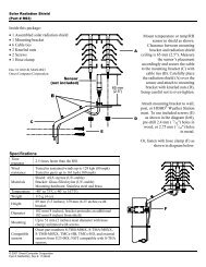
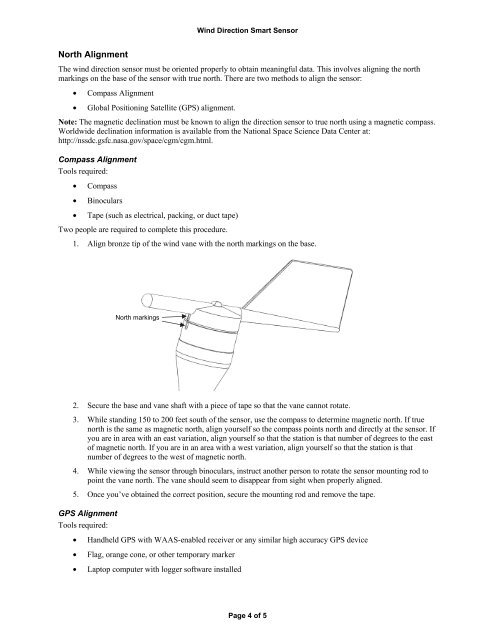
1. Align bronze tip of the wind vane with the north markings on the base.<br />
North markings<br />
2. Secure the base and vane shaft with a piece of tape so that the vane cannot rotate.<br />
3. While standing 150 to 200 feet south of the sensor, use the <strong>com</strong>pass to determine magnetic north. If true<br />
north is the same as magnetic north, align yourself so the <strong>com</strong>pass points north and directly at the sensor. If<br />
you are in area with an east variation, align yourself so that the station is that number of degrees to the east<br />
of magnetic north. If you are in an area with a west variation, align yourself so that the station is that<br />
number of degrees to the west of magnetic north.<br />
4. While viewing the sensor through binoculars, instruct another person to rotate the sensor mounting rod to<br />
point the vane north. The vane should seem to disappear from sight when properly aligned.<br />
5. Once you’ve obtained the correct position, secure the mounting rod and remove the tape.<br />
GPS Alignment<br />
Tools required:<br />
• Handheld GPS with WAAS-enabled receiver or any similar high accuracy GPS device<br />
• Flag, orange cone, or other temporary marker<br />
• Laptop <strong>com</strong>puter with logger software installed<br />
Page 4 of 5