


You also want an ePaper? Increase the reach of your titles
YUMPU automatically turns print PDFs into web optimized ePapers that Google loves.
SMALLER, LIGHTER, FASTE<br />
AND STILLYELLOW l<br />
You're looking at the future of surveying. A future<br />
in which a single surveyor can handle more<br />
work, and more kinds of work, than ever be<strong>for</strong>e.<br />
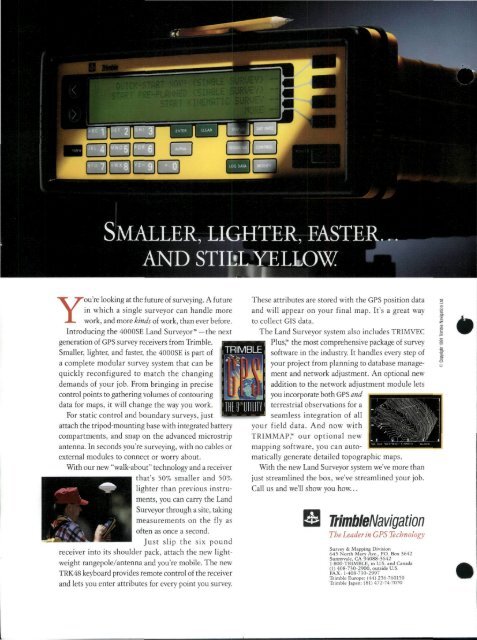
Introducing the 4000SE Land <strong>Surveyor</strong> —the next<br />
generation of GPS survey receivers from Trimble.<br />
Smaller, lighter, and faster, the 4000SE is part of<br />
a complete modular survey system that can be<br />
quickly reconfigured to match the changing<br />
demands of your job. From bringing in precise<br />
control points to gathering volumes of contouring<br />
data <strong>for</strong> maps, it will change the way you work.<br />
For static control and boundary surveys, just<br />
attach the tripod-mounting base with integrated battery<br />
compartments, and snap on the advanced microstrip<br />
antenna. In seconds you're surveying, with no cables or<br />
external modules to connect or worry about.<br />
With our new "walk-about" technology and a receiver<br />
that's 50% smaller and 50%<br />
lighter than previous instruments,<br />
you can carry the Land<br />
<strong>Surveyor</strong> through a site, taking<br />
measurements on the fly as<br />
often as once a second.<br />
Just slip the six pound<br />
receiver into its shoulder pack, attach the new lightweight<br />
rangepole/antenna and you're mobile. <strong>The</strong> new<br />
TRK48 keyboard provides remote control of the receiver<br />
and lets you enter attributes <strong>for</strong> every point you survey.<br />
TRIMBLE<br />
<strong>The</strong>se attributes are stored with the GPS position data<br />
and will appear on your final map. It's a great way<br />
to collect GIS data.<br />
<strong>The</strong> Land <strong>Surveyor</strong> system also includes TRIMVEC<br />
Plus, the most comprehensive package of survey<br />
software in the industry. It handles every step of<br />
your project from planning to database management<br />
and network adjustment. An optional new<br />
addition to the network adjustment module lets<br />
you incorporate both GPS and<br />
terrestrial observations <strong>for</strong> a<br />
seamless integration of all<br />
your field data. And now with<br />
TRIMMAP, our optional new<br />
mapping software, you can automatically<br />
generate detailed topographic maps.<br />
With the new Land <strong>Surveyor</strong> system we've more than<br />
just streamlined the box, we've streamlined your job.<br />
Call us and we'll show you how...<br />
TrimbleNavigation<br />
<strong>The</strong> Leader in GPS Technology<br />
Survey & Mapping Division<br />
645 North Mary Ave., PO. Box 3642<br />
Sunnyvale, CA 94088-3642<br />
1-800-TRIMBLE, in US. and Canada<br />
(1) 408-730-2900, outside U.S.<br />
FAX: 1-408-730-2997<br />
Trimble Europe: (44) 256-760150<br />
Trimble Japan: (81) 472-74-7070<br />
•


