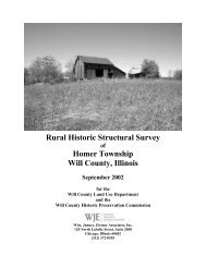
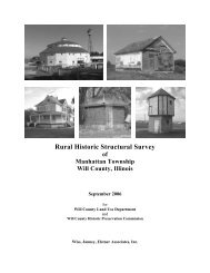
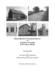
Rural Historic Structural Survey - Will County Land Use
Rural Historic Structural Survey - Will County Land Use
Rural Historic Structural Survey - Will County Land Use

Create successful ePaper yourself
Turn your PDF publications into a flip-book with our unique Google optimized e-Paper software.
Wiss, Janney, Elstner Associates, Inc.<br />
November 2001<br />
EXECUTIVE SUMMARY<br />
At the request of the <strong>Will</strong> <strong>County</strong> <strong>Land</strong> <strong>Use</strong> Department (<strong>Will</strong> <strong>County</strong>), acting as liaison for the <strong>Will</strong><br />
<strong>County</strong> <strong>Historic</strong> Preservation Commission (<strong>Historic</strong> Preservation Commission), Wiss, Janney, Elstner<br />
Associates, Inc. (WJE) has prepared the following report of the intensive survey of existing farmsteads in<br />
unincorporated Du Page Township in <strong>Will</strong> <strong>County</strong>, Illinois. WJE has previously performed an intensive<br />
survey of Wheatland, Plainfield, and Lockport Townships, with a final report dated November 2000.<br />
Most of the survey of Du Page Township was performed in April and May 2001, with follow-up survey<br />
in August and November 2001, and includes 36 square miles with 27 farmsteads containing 131<br />
individual structures. This intensive survey was performed to update the previous survey of the township<br />
performed in 1988, which identified 76 farmsteads with 411 individual structures. Therefore, in the 13<br />
years between the survey efforts a significant number of rural structures, as well as rural character and<br />
heritage, have been lost. Of the 27 farmsteads identified, 5 are individually eligible for <strong>Will</strong> <strong>County</strong><br />
<strong>Historic</strong> <strong>Land</strong>mark status and/or National Register of <strong>Historic</strong> Places designation; 15 have sufficient<br />
integrity to contribute to a potential <strong>Will</strong> <strong>County</strong> or National Register rural heritage historic district; and 7<br />
lack sufficient historic integrity to contribute to a historic district. Approximately one-half of the<br />
farmsteads in the township are actively engaged in some form of agricultural production. However,<br />
although many structures survive on farmsteads in Du Page Township and northwest <strong>Will</strong> <strong>County</strong>, they<br />
are under increasing threat without the former vitality of the agricultural economy.<br />
Northwest <strong>Will</strong> <strong>County</strong> was settled by pioneer farmers of European origin beginning in the late 1820s.<br />
Two subsequent historical developments led to an increase in settlement: more land in the region became<br />
available after the Treaty of Chicago of 1833 resettled the remaining Native Americans to west of the<br />
Mississippi; and the decision to build the Illinois and Michigan Canal, begun in 1836. By the time the<br />
canal opened in 1848, the towns of Plainfield and Lockport had been founded (in 1834 and 1836<br />
respectively) and farmers were established in Wheatland and Du Page Townships. The canal promoted<br />
the use of Chicago as a port city and reoriented the growth center of Illinois from the southern end of the<br />
state to the north. The canal helped farmers move their harvests and livestock to market. Within a few<br />
years, the railroad arrived to the region, offering farmers an additional means of transporting their bounty<br />
to Chicago and elsewhere. The canal gradually declined in use with the spread of the railroads; however,<br />
routing of the Sanitary and Ship Canal in the 1890s parallel to the canal renewed the waterways in the<br />
region for shipping purposes. Other transportation arteries included the Elgin, Joliet & Eastern Railroad,<br />
established in the late 1880s, and the routing of U.S. 30 through Joliet and Plainfield in the 1910s.<br />
Although these transportation arteries also served newly established industries in the area, they served the<br />
vital agricultural economy of northwest <strong>Will</strong> <strong>County</strong> until its decline in the last half of the twentieth<br />
century.<br />
The <strong>Rural</strong> Structures <strong>Survey</strong> of unincorporated <strong>Will</strong> <strong>County</strong> performed in 1988 identified approximately<br />
21,000 structures, 343 of which were noted to be potentially significant. The 1988 survey documented<br />
sites with photographs and survey data on standard Illinois <strong>Historic</strong> Preservation Agency format cards.<br />
For most sites, the data for the 1988 survey was gathered from the public right-of-way. In addition to this<br />
survey a report, was prepared examining the overall rural themes present in the county and identifying<br />
noteworthy structures. In 1999 and 2000, an intensive survey of Wheatland, Plainfield, and Lockport<br />
Townships was performed by WJE. The survey area includes 108 square miles of land, 227 farmsteads<br />
and historically related sites, and 890 individual structures. This report incorporates information from the<br />
final report November 2000, but with additional historical information obtained during the survey of Du<br />
Page Township.<br />
Because of the numerous changes that have occurred in the years since the first rural survey in 1988, the<br />
<strong>Will</strong> <strong>County</strong> <strong>Historic</strong> Preservation Commission recognized the need to reassess the agricultural heritage<br />
<strong>Will</strong> <strong>County</strong> <strong>Rural</strong> <strong>Historic</strong> <strong>Structural</strong> <strong>Survey</strong><br />
Du Page Township