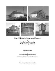
Rural Historic Structural Survey - Will County Land Use
Rural Historic Structural Survey - Will County Land Use
Rural Historic Structural Survey - Will County Land Use

Create successful ePaper yourself
Turn your PDF publications into a flip-book with our unique Google optimized e-Paper software.
Wiss, Janney, Elstner Associates, Inc.<br />
The Native Americans who occupied the area at this time were divided into powerful tribes who at times<br />
fought the European settlers to hold their hunting grounds. Chief among these tribes was the Kickapoo,<br />
who were among the first to engage in war with European settlers and the last to enter into treaties with<br />
the United States government. On 30 July 1819, by the Treaty at Edwardsville, the Kickapoo ceded their<br />
land to United States and began to retreat to Osage <strong>County</strong>. By 1822, only 400 Kickapoo were left in the<br />
state. The Peace Treaty of Tippecanoe of 1832 was negotiated with the Potawatomi tribe, resulting in the<br />
ceding of the land now occupied by Chicago and Joliet to the federal government.<br />
The early 1830s saw the greatest land boom thus far in American history. <strong>Land</strong> sales gradually came<br />
under the control of the General <strong>Land</strong> Office as the survey moved westward. In 1834 and 1835 alone, 28<br />
million acres were shifted from closed to open land for purchase. Two years later the Van Buren<br />
administration placed an enormous 56,686,000 acres on the market. These lands were located in some of<br />
the most fertile farming regions of the nation: Illinois, Iowa, Alabama, Mississippi, Arkansas, and<br />
Missouri. 24 The building of the Illinois and Michigan Canal in the later 1830s and 1840s (discussed in<br />
Chapter II) led to a land boom in Chicago, which had been platted in 1830 and incorporated in 1833. 25<br />
The rate of growth in northern Illinois soon matched and then surpassed that of the southern portion of the<br />
state.<br />
Settlement and Development of <strong>Will</strong> <strong>County</strong><br />
By 1826, more European settlers began to move to the northeast Illinois region, so that by 1831 a few<br />
hamlets were present between LaSalle and Chicago. Also present in the region was a tribe of nearly 1,000<br />
Potawatomi in the area along the Du Page River south of what would become Plainfield. 26 At the<br />
beginning of the Black Hawk War in 1832 the largest settlement north of the Illinois River (except for<br />
Chicago) was on Bureau Creek, where there were about 30 families. A few other settlers had located on<br />
the river at Peru and LaSalle, and a considerable number at Ottawa. At Walker’s Grove or Plainfield,<br />
there were 12 or 15 families. 27 Along the branch of the Du Page, partially located in the region that would<br />
become <strong>Will</strong> <strong>County</strong> in 1836, there were about twenty families. In Yankee settlements, which embraced<br />
part of the towns of Homer, Lockport and New Lenox, there were 20 or 25 families. Along the Hickory in<br />
the town of New Lenox, including the Zarley settlement in Joliet Township, there were approximately 20<br />
more families, and at the Reed’s and Jackson Grove there were 6 or 8 more. 28<br />
In 1832, a band of Sauk Indians led by Black Sparrow Hawk, resisted their deportation by Europeans<br />
settlers from their ancestral lands. Although most of the fighting occurred in the Rock River area in<br />
Northwest Illinois and southern Wisconsin, an Indian panic swept through <strong>Will</strong> <strong>County</strong> settlements. The<br />
settlers in Walker’s Grove together with about 25 fugitives from the Fox River area hurriedly constructed<br />
a stockade from the logs of Stephen Begg’s pigpen, outbuildings, and fences (“Fort Beggs”). The prospect<br />
of engaging Indians in pitched battle from the confines of “Fort Beggs” prompted the settlers to leave the<br />
makeshift stockade in favor of Fort Dearborn in Chicago. Meanwhile homesteaders in the eastern <strong>Will</strong><br />
<strong>County</strong> area gathered at the Gougar homestead and decided to flee to Indiana. 29<br />
24 Ibid., 51.<br />
25 Between 1840 and 1860 the population of Chicago increased from 4,470 to nearly 100,000, growth tied to the<br />
economic boom started by the opening of the Illinois and Michigan Canal. By 1890, Chicago’s population was more<br />
than 1,000,000 persons (Harry Hansen, ed., Illinois: A Descriptive and <strong>Historic</strong>al Guide (New York: Hastings<br />
House Publishers, 1974), 176–83).<br />
26 Herath, Indians and Pioneers: A Prelude to Plainfield, Illinois, 21.<br />
27 A Potawatomi village was located to the south of Walker’s Grove. (Map 26, Helen Hornbeck Tanner, ed., Atlas of<br />
Great Lakes Indian History (Norman, Oklahoma: University of Oklahoma Press, 1987), 140.)<br />
28 Ibid.<br />
29 Robert E. Sterling, A Pictorial History of <strong>Will</strong> <strong>County</strong>, Volume 1 (Joliet: <strong>Will</strong> <strong>County</strong> <strong>Historic</strong>al Publications,<br />
1975).<br />
<strong>Will</strong> <strong>County</strong> <strong>Rural</strong> <strong>Historic</strong> <strong>Structural</strong> <strong>Survey</strong><br />
Du Page Township Chapter I – 13