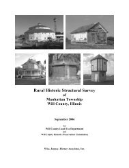
Rural Historic Structural Survey - Will County Land Use
Rural Historic Structural Survey - Will County Land Use
Rural Historic Structural Survey - Will County Land Use

You also want an ePaper? Increase the reach of your titles
YUMPU automatically turns print PDFs into web optimized ePapers that Google loves.
Wiss, Janney, Elstner Associates, Inc.<br />
CHAPTER I:<br />
CONTEXT HISTORY OF THE RURAL SURVEY AREA<br />
Geologic and Topographic Background to the Illinois Region<br />
Du Page, Wheatland, Plainfield, and Lockport Townships are located at the northeast edge of the<br />
Mississippi River drainage basin. The region contains two rivers, the Des Plaines River and its largest<br />
tributary, the Du Page River, that flows in turn to the Illinois River and on to the Mississippi. Each of the<br />
rivers has a number of tributary creeks and streams. In Lockport Township, the Des Plaines has Fraction<br />
Run in the southeast portion of the township. The Du Page has Spring Brook in northeast Wheatland<br />
Township and Lily Cache Creek (and its tributary, Mink Creek) in the eastern half of Plainfield Township.<br />
As with most of Illinois, the survey area was profoundly altered by glaciation. The region surrounding<br />
Joliet is a zone of fairly old limestones, sandstones, and shales where older rocks of Ordovician and<br />
Silurian age to the north give way near the surface to younger coal-rich rocks of Pennsylvanian age to the<br />
south. The surface topography of the land often bears little resemblance to that of the bedrock beneath.<br />
For example, although the Des Plaines River occupies a true rock valley, the Du Page River only does so<br />
for a portion of its run. Northeast of the survey area, the East Branch of the Du Page River occupies a<br />
glacial drift valley over a rock valley; however, the drift valley slopes south and the rock valley slopes<br />
north. 1<br />
Over approximately one million years, the northern hemisphere was alternately covered by and free of large<br />
ice sheets that were hundreds to a few thousand feet thick during the Pleistocene era. In the United States,<br />
portions of New England and the upper Midwest were the most affected by glaciation, with nearly all of the<br />
these areas covered by ice at one time or another. 2 Illinois was covered by ice sheets in four major periods,<br />
with only the far northwest and far southern portions of the state relatively unaffected. Most of the glacial<br />
deposits in the state date from the last two periods: the Illinoian and the Wisconsin. Lake Michigan was<br />
formed by successive advances, but took its current form during the Wisconsin Period. The Illinoian reached<br />
as far south as Carbondale and Harrisburg, the Wisconsin only to Mattoon and Peoria. In addition to<br />
deposits from glaciation, streams and rivers formed by the melting glaciers deposited sand and gravel across<br />
the landscape.<br />
Pleistocene glaciers and the waters melting from them changed the landscapes they covered. The ice scraped<br />
and smeared the landforms it overrode, leveling and filling many of the minor valleys and even some of the<br />
larger ones. Moving ice carried colossal amounts of rock and earth, for much of what the glaciers wore off<br />
the ground was kneaded into the moving ice and carried along, often for hundreds of miles. Wisconsinan drift<br />
was deposited on the weathered Illinoian drift in much of Illinois.<br />
A significant feature left by the advance and retreat of glaciers in the northeast corner of the state are glacial<br />
moraines—low mounds tens of miles long left by the furthest advance of a glaciers in the Wisconsinan<br />
period. The townships in the survey area lie to the west of one of the most pronounced moraines, the<br />
Valparaiso Morainic System. Immediately west of the Des Plaines River Valley in Lockport Township is the<br />
1 D.J. Fisher, Geology and Mineral Resources of the Joliet Quadrangle, Bulletin No. 51 of the Illinois State<br />
Geological <strong>Survey</strong> (Urbana, Illinois, 1925), 95. This reference was brought to the attention of the project team by<br />
Mr. Michael A. Lambert of Plainfield.<br />
2 Besides the physical impact of the ice sheets in the above named regions was the overall climatic changes that<br />
occurred in North America. See E.C. Pielou, After the Ice Age: The Return of Life to Glaciated North America<br />
(Chicago: University of Chicago Press, 1991) for an analysis of the biological recovery after the retreat of last ice<br />
sheets.<br />
<strong>Will</strong> <strong>County</strong> <strong>Rural</strong> <strong>Historic</strong> <strong>Structural</strong> <strong>Survey</strong><br />
Du Page Township Chapter I – 1