Queensland Guidelines: Meat Chicken Farms - Department of ...
Queensland Guidelines: Meat Chicken Farms - Department of ...
Queensland Guidelines: Meat Chicken Farms - Department of ...

You also want an ePaper? Increase the reach of your titles
YUMPU automatically turns print PDFs into web optimized ePapers that Google loves.
Calculation <strong>of</strong> separation distances for each sensitive land use within a rural zone and the closest<br />
boundary <strong>of</strong> the non-rural zone is as follows:<br />
Separation distance (D) = N 0.63 xS1xS2xS3<br />
N – Maximum number <strong>of</strong> birds (to be housed on the farm at any one time) divided by 1000.<br />
0.63 – Exponent determined using the results <strong>of</strong> modelling.<br />
S1 – Sensitive land use factor for estimating the relative odour impact potential <strong>of</strong> a development.<br />
S2 – Surface roughness factor for estimating the potential changes to odour dispersion due to changes in<br />
the land surface.<br />
S3 – Terrain weighting factor for estimating the potential changes to odour dispersion in situations where<br />
meteorological conditions may be influenced by local terrain influences.<br />
Note: The separation distance formula only applies to farms up to 300 000 birds.<br />
The S-factors to be used with this formula are presented in Table 1.<br />
The available separation distances between the meat chicken farm and sensitive land uses are<br />
generally the key factors limiting the number <strong>of</strong> birds that can be accommodated on a particular<br />
site. Separation distances require assessment in all directions to ensure that the potential for<br />
unacceptable odour nuisance is minimised. Where other significant odour sources are located in<br />
proximity to the proposed meat chicken farm, the cumulative odour impact from both sites may<br />
require consideration.<br />
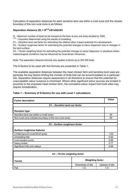
Table 1 – Summary <strong>of</strong> S-factors for use with Level 1 calculations<br />
Factor description<br />
Value<br />
S1 – Sensitive land use factor<br />
Receptor type<br />
Sensitive land use (within a rural zone) 30<br />
Non-rural zone (closest boundary <strong>of</strong> the non-rural zone) 50<br />
S2 – Surface roughness factor<br />
Surface roughness features<br />
Limited ground cover/short grass 1.00<br />
Undulating hills 0.93<br />
Level wooded country 0.85<br />
Heavy timber 0.77<br />
Significant hills and valleys 0.68<br />
S3 – Terrain weighting factor<br />
Terrain<br />
Weighting factor<br />
Downslope <strong>of</strong> site Upslope <strong>of</strong> site<br />
Flat 1.0 1.0<br />
<strong>Queensland</strong> <strong>Guidelines</strong> <strong>Meat</strong> <strong>Chicken</strong> <strong>Farms</strong> 48