Read the full report (PDF27.8 MB) - CO2CRC
Read the full report (PDF27.8 MB) - CO2CRC
Read the full report (PDF27.8 MB) - CO2CRC

Create successful ePaper yourself
Turn your PDF publications into a flip-book with our unique Google optimized e-Paper software.
The Wunger Ridge area (60 km by 40 km; southwest Bowen Basin) was considered too large to run<br />
a <strong>full</strong> reservoir simulation at an appropriate resolution. A small 29.5 km by 10 km area on <strong>the</strong><br />
Wunger Ridge flank contained many of <strong>the</strong> geological and hydrological elements expected to be<br />
found along <strong>the</strong> western flank of <strong>the</strong> Bowen Basin, and as such, results were deemed potentially<br />
transferable to o<strong>the</strong>r areas of <strong>the</strong> basin. Simple 2D and 3D geological models were built and<br />
reservoir simulations were run using multiple scenarios to provide <strong>the</strong> greatest amount of<br />
understanding of <strong>the</strong> more significant factors affecting <strong>the</strong> behaviour of CO 2 in <strong>the</strong> subsurface.<br />
This <strong>report</strong> principally focuses on <strong>the</strong> geology, hydrodynamics, geophysics, and reservoir<br />
engineering aspects of <strong>the</strong> Wunger Ridge flank site. The <strong>report</strong> also summarises <strong>the</strong> geoscientific<br />
findings of <strong>the</strong> regional evaluations.<br />
4
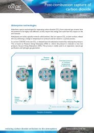
![Post-combustion solvent absorption [PDF 438KB] - CO2CRC](https://img.yumpu.com/48575763/1/184x260/post-combustion-solvent-absorption-pdf-438kb-co2crc.jpg?quality=85)