Read the full report (PDF27.8 MB) - CO2CRC
Read the full report (PDF27.8 MB) - CO2CRC
Read the full report (PDF27.8 MB) - CO2CRC

Create successful ePaper yourself
Turn your PDF publications into a flip-book with our unique Google optimized e-Paper software.
Moonie Oil Field<br />
PL 1 permit, Surat Basin, onshore eastern Queensland, approximately 300 kilometres west of<br />
Brisbane. Santos Ltd has a 100% interest and is <strong>the</strong> operator (Santos, 2005).<br />
Oil was discovered on <strong>the</strong> Moonie Anticline within <strong>the</strong> Jurassic Precipice Formation in 1961.<br />
The 24.3 million-barrel (3859 mega litre) oil field was brought into production during 1964 with<br />
peak production of approximately 9000 bbls/day occurring during 1966. As at 1996 cumulative<br />
oil production was approximately 3686 mega litres (23.2 MMbbls).The Precipice Sandstone at <strong>the</strong><br />
Moonie location has an average permeability of 290 mD with an average porosity of 18% (Cadman<br />
et al. 1998).<br />
The field is in <strong>the</strong> latter stages of decline with 0.0694 mmboe of crude oil produced during 2004<br />
with a very high water cut. Most of <strong>the</strong> 50 wells at Moonie and <strong>the</strong> nearby satellite fields are shut in,<br />
and less than 10 wells are still producing. Eight wells on <strong>the</strong> fields are used for water injection.<br />
Recently a 3D seismic survey has been acquired over <strong>the</strong> field<br />
(http://www.santos.com.au/Content.aspx?p=2268).<br />
The Moonie field has <strong>the</strong> potential to be suitable for enhanced oil recovery or as a CO 2 storage site.<br />
As cooperation with Santos Ltd would be required for this to be realised, it was thought impractical<br />
to make it <strong>the</strong> subject of a separate geological or geophysical review with <strong>the</strong> limited available open<br />
file data. This is particularly true considering that post 3D data acquisition, all available seismic,<br />
well and field data would have been incorporated into determining <strong>the</strong> location of <strong>the</strong> two<br />
subsequent wells drilled on <strong>the</strong> Moonie structure.<br />
The GEODISC project concluded that, depleted gas fields in <strong>the</strong> Surat Basin (UEI’s 30, 31, 33, 34,<br />
and 35) represent a very low risk sequestration option with a high geologic chance of success<br />
(35-52%) for volumes of < 0.19 TCF of CO 2 (Bradshaw et al., 2003).<br />
3.3. Older/Deeper Basins<br />
3.3.1 Cooper Basin<br />
The Cooper Basins’ location in central Australia is approximately 1000 km from <strong>the</strong> nearest coal<br />
fired power station. Exploiting petroleum resources from <strong>the</strong> Cooper Basin is <strong>the</strong> primary activity<br />
at this time. This activity results in <strong>the</strong> venting to <strong>the</strong> atmosphere of potentially sequesterable CO 2 .<br />
The Cooper Basin has not been reviewed in this study.<br />
The GEODISC project concluded that, <strong>the</strong> Cooper Basin is an ideal site for carbon-dioxide<br />
sequestration with a 90% chance of successful CO 2 sequestration (Bradshaw et al., 2003).<br />
3.3.2 Devonian to Carboniferous Basins (Warburton, Adavale, Drummond, Hodgkinson,<br />
Gilberton, Bundock, Clarke River, and Burdekin Basins).<br />
The Carboniferous to Devonian Adavale Basin has <strong>the</strong> highest storage potential of <strong>the</strong> older basins,<br />
although comparatively this is still low and containment may be problematic due to fault leakage<br />
and <strong>the</strong> potential for injected CO 2 to dissolve <strong>the</strong> carbonate formations. The basin has been<br />
extensively investigated with 46 exploration wells and 11 appraisal wells, with <strong>the</strong> most likely<br />
storage option being within <strong>the</strong> Gilmore field once it is depleted. The Gilmore field is a 118 BCF,<br />
3352 m deep potentially fault controlled gas field and is <strong>the</strong> only commercial hydrocarbon<br />
accumulation discovered in <strong>the</strong> basin to date (deBoer, 1996). Sedimentary rocks<br />
within Devonian ─ Carboniferous aged basins, tend to be diagenetically altered, with sediments<br />
buried deeply. Additionally reservoir characteristics are poor and <strong>the</strong> basins are overlain by up to<br />
1000 -3000 m of superior reservoirs (Miyazaki & Ozmic, 1987). The reservoir quality, remoteness<br />
from CO 2 sources, and juxtaposition with more suitable storage options makes <strong>the</strong>se basins<br />
unsuitable for CO 2 storage.<br />
16
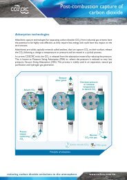
![Post-combustion solvent absorption [PDF 438KB] - CO2CRC](https://img.yumpu.com/48575763/1/184x260/post-combustion-solvent-absorption-pdf-438kb-co2crc.jpg?quality=85)