Read the full report (PDF27.8 MB) - CO2CRC
Read the full report (PDF27.8 MB) - CO2CRC
Read the full report (PDF27.8 MB) - CO2CRC

You also want an ePaper? Increase the reach of your titles
YUMPU automatically turns print PDFs into web optimized ePapers that Google loves.
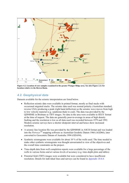
Figure 4.2. Location of core samples examined in <strong>the</strong> greater Wunger Ridge area. See also Figure 2.1c for<br />
location relative to <strong>the</strong> Bowen Basin.<br />
4.2. Geophysical data<br />
Datasets available for <strong>the</strong> seismic interpretation are listed below.<br />
• Reflection seismic data were available in printed format, mostly as final stacks with<br />
occasional migrated stacks. The seismic data used was normal polarity (Australian standard,<br />
reverse USA) producing a peak (right hand deflection) as <strong>the</strong> seismic wave moves from high<br />
to low velocity material (e.g. sandstone/shale to coal). The data was provided by <strong>the</strong><br />
QDNRME in Brisbane as TIFF images. No data in <strong>the</strong> area were available in SEGY format<br />
at <strong>the</strong> time of request. The data are generally poor-to-average in areas of high density<br />
faulting and <strong>the</strong> resolution is low as all data used was recorded between 1979 and 1992.<br />
Modern seismic surveys have a shorter shotpoint interval and hence show increased<br />
resolution.<br />
• A seismic line location file was provided by <strong>the</strong> QDNRME in ASCII format and was loaded<br />
into <strong>the</strong> Petrosys TM mapping software as Australian Geodetic Datum 1966 (AGD66), later<br />
converted to Geocentric Datum of Australia 1994 (GDA94).<br />
• Syn<strong>the</strong>tic seismograms were available for about 10 % of <strong>the</strong> wells used. The time needed to<br />
make o<strong>the</strong>r syn<strong>the</strong>tic seismograms was thought unwarranted in view of <strong>the</strong> objectives and<br />
<strong>the</strong> overall time constraints on <strong>the</strong> project.<br />
• Time-depth data from well completion <strong>report</strong>s were available for a large percentage of <strong>the</strong><br />
wells in various forms and at various levels of accuracy (e.g. time-depth plots and tables)<br />
• Potential field (TIFF) images were available but were considered to have insufficient<br />
resolution. Details for individual lines and surveys can be found in Appendix 10.6.6.<br />
30
![Post-combustion solvent absorption [PDF 438KB] - CO2CRC](https://img.yumpu.com/48575763/1/184x260/post-combustion-solvent-absorption-pdf-438kb-co2crc.jpg?quality=85)