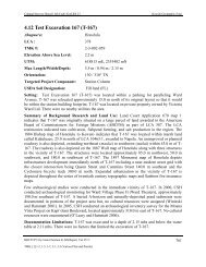
AISP Kamehameha Highway Guideway - Honolulu Rail Transit Project
AISP Kamehameha Highway Guideway - Honolulu Rail Transit Project
AISP Kamehameha Highway Guideway - Honolulu Rail Transit Project

Create successful ePaper yourself
Turn your PDF publications into a flip-book with our unique Google optimized e-Paper software.
Cultural Surveys Hawai‘i Job Code: MANANA 1<br />
Introduction<br />
temperature is 73° F. Molokai soils are geographically associated with Holomua,<br />
Keahua, Lahaina, and Uwala soils.<br />
In this survey area a shallow variant of the Molokai series was mapped. This soil,<br />
Molokai silty clay loam, shallow variant, 15 to 25 percent slopes, severely eroded,<br />
is described in alphabetical order, along with other mapping units of this series.<br />
These soils are used for sugarcane, pineapple, pasture, wildlife habitat, and home<br />
sites. The natural vegetation consists of kiawe, ‘ilima, uhaloa, feather fingergrass,<br />
and buffalo grass. [Foote et al. 1972:96]<br />
Soils of the Pearl Harbor Series are described as follows:<br />
This series consists of very poorly drained soils on nearly level coastal plains on<br />
the island of Oahu. These soils developed in alluvium overlying organic material.<br />
Elevations range from nearly sea level to 5 feet. The annual rainfall amounts to 18<br />
to 40 inches. The mean annual soil temperature is 74° F. Pearl Harbor soils are<br />
geographically associated with Hanalei, Kaloko, and Keaau soils.<br />
These soils are used for taro, sugarcane, and pasture. The natural vegetation<br />
consists of cattails, mangrove trees, California grass, and sedges. [Foote et al.<br />
1972:112]<br />
Rock Land sediments are described as follows:<br />
Rock land (rRK) is made up of areas where exposed rock covers 25 to 90 percent<br />
of the surface. It occurs on all five islands. The rock outcrops and very shallow<br />
soils are the main characteristics. The rock outcrops are mainly basalt and<br />
andesite. This land type is nearly level to very steep. Elevations range from nearly<br />
sea level to more than 6,000 feet. The annual rainfall amounts to 15 to 60 inches.<br />
Rock land is used for pasture, wildlife habitat, and water supply. The natural<br />
vegetation at the lower elevations consists mainly of kiawe, klu, piligrass,<br />
Japanese tea, and koa haole. Lantana, guava, Natal redtop, and molassesgrass are<br />
dominant at the higher elevations. Thais land type is also used for urban<br />
development. In many areas, especially on the island of Oahu, the soil material<br />
associated with the rock outcrops is very sticky and very plastic. It also has high<br />
shrink-swell potential. Buildings on the steep slopes are susceptible to sliding<br />
when the soil is saturated. Foundations and retaining walls are susceptible to<br />
cracking. [Foote et al. 1972:119]<br />
Soils of the Tropaquepts Series are described as follows:<br />
Tropaquepts (TR) are poorly drained soils that are periodically flooded by<br />
irrigation in order to grow crops that thrive in water. They occur as nearly level<br />
flood plains on the islands of Oahu and Maui. Elevations range from sea level to<br />
200 feet. The annual rainfall amounts to 20 to 150 inches.<br />
These soils have been flooded for varying lengths of time, and soil development<br />
differs in degree from place to place. Generally, the surface layer, about 10 inches<br />
Archaeological Inventory Survey Plan, HHCTCP Construction Phase II, Waiawa, Mānana, Waimano, Waiau,<br />
Waimalu, Kalauao, ‘Aiea, and Hālawa Ahupua‘a, ‘Ewa District, Island of O‘ahu<br />
TMK[1] 9-7, 9-8, and 9-9 - Various Plats and Parcels<br />
12