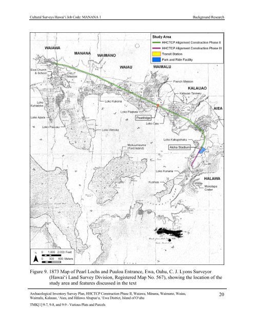
Cultural Surveys Hawai‘i Job Code: MANANA 1 Background Research Figure 9. 1873 Map of Pearl Lochs and Puuloa Entrance, Ewa, Oahu, C. J. Lyons Surveyor (Hawai‘i Land Survey Division, Registered Map No. 567), showing the location of the study area and features discussed in the text Archaeological Inventory Survey Plan, HHCTCP Construction Phase II, Waiawa, Mānana, Waimano, Waiau, Waimalu, Kalauao, ‘Aiea, and Hālawa Ahupua‘a, ‘Ewa District, Island of O‘ahu TMK[1] 9-7, 9-8, and 9-9 - Various Plats and Parcels 20
Cultural Surveys Hawai‘i Job Code: MANANA 1 Background Research Loko Welokā, a large fishpond with a small island in the center, was located in Waimano, along the eastern shore of the Manana Peninsula (see Figure 9). The word welokā is translated as “thrashing, smiting, as a fishtail” (Pukui and Elbert 1971:355), which may also be a reference to the shark demigoddess associated with Waimano. Loko Kūkona, another large fishpond in Waimano, was located along the northern coast of Pearl Harbor (see Figure 9). The word kūkona is translated as “unfriendly, cross, or sullen” (Pukui and Elbert 1971:163). Waiau Waiau Ahupua‘a extends from the East Loch of Pearl Harbor to the crest of the Ko‘olau Range, generally following Waiau Gulch. Waiau Spring and Waiau Pond are located near the Pearl Harbor coast. Waiau is translated as “swirling water” (Pukui et al. 1974:221). However, Thrum (1922:672) indicates the pronunciation is Wai‘au, meaning “water to swim in.” A small fishery was also attached to Waiau Ahupua‘a. The fishery was named Kai o Kalua‘o‘opu, which is translated as “the hole” (ka lua) of the “goby fish” (‘o‘opu) (Pukui and Elbert 1971:196,267). Puhikani, a locality in Waiau was also mentioned as “a bathing place of the shark chiefess, Kaahupahau” (Ke Au Hou, Dec. 21, 1910, cited in Sterling and Summers 1978:16). Waimalu Waimalu Ahupua‘a extends from the East Loch of Pearl Harbor to the crest of the Ko‘olau Range, generally following Waimalu Stream. The word waimalu is translated as “sheltered water” (Pukui et al. 1974:225), likely in reference to Pearl Harbor and the fishponds along the coast. Loko Pa‘akea, a large fishpond in Waimalu along the Pearl Harbor coast (see Figure 9), was said to have been built by the chiefess, Kalaimanuia (McAllister 1933:103-104). The word pa‘akea is translated as “coral bed, limestone” (Pukui et al. 1974:173). The offshore island of Moku‘um‘ume (Ford Island) (see Figure 9) was considered part of Waimalu Ahupua‘a. McAllister (1933:102) indicates the place name means “‘Isle of Strife’ from the fact that among former chiefs it was the center of contention over certain fishing rights.” Pukui et al. (1974:156) state that the island was named for the ‘ume, a sexual game that was once played on the island. Kalauao Kalauao Ahupua‘a extends from the East Loch of Pearl Harbor to the crest of the Ko‘olau Range, generally following Kalauao Stream. Kalauao Spring is located near the Pearl Harbor coast. The word kalauao is translated as “the multitude of clouds” (Pukui et al. 1974:75). Pu‘u Kaiwipo‘o, a peak on the ridge separating Kalauao and Hālawa Ahupua‘a, is translated as “the skull hill” (Pukui et al. 1974:197). A small waterfall along Kalauao Stream, named Kahuawai (or Kahuewai), was located along the coastal trail connecting <strong>Honolulu</strong> to Wai‘anae. Kahuawai, translated as “water gourd container,” was indicated to have been “a favorite resting place exclusively for chiefs” (Pukui et al. 1974:66). Loko Opu, a large fishpond located in Kalauao along the Pearl Harbor coast (see Figure 9), is said to have been built by the chiefess Kalamanu‘ia (McAllister 1933:103). Archaeological Inventory Survey Plan, HHCTCP Construction Phase II, Waiawa, Mānana, Waimano, Waiau, Waimalu, Kalauao, ‘Aiea, and Hālawa Ahupua‘a, ‘Ewa District, Island of O‘ahu TMK[1] 9-7, 9-8, and 9-9 - Various Plats and Parcels 21