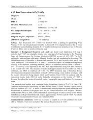
AISP Kamehameha Highway Guideway - Honolulu Rail Transit Project
AISP Kamehameha Highway Guideway - Honolulu Rail Transit Project
AISP Kamehameha Highway Guideway - Honolulu Rail Transit Project

Create successful ePaper yourself
Turn your PDF publications into a flip-book with our unique Google optimized e-Paper software.
Cultural Surveys Hawai‘i Job Code: MANANA 1<br />
Figure 18. 1927-1928 U.S. Geological Survey Topographic Map, Waipahu Quadrangle,<br />
showing the location of the study area and features discussed in the text ......................62<br />
Figure 19. 1943 War Department Topographic Map, Aiea Quadrangle, showing the<br />
location of the study area and features discussed in the text ..........................................63<br />
Figure 20. 1953 Army Mapping Service Topographic Map, Waipahu and Puuloa<br />
Quadrangles, showing the location of the study area and features discussed in the<br />
text...................................................................................................................................65<br />
Figure 21. 1977 U.S. Geological Survey Orthophotograph, Waipahu and Puuloa<br />
Quadrangles, showing the location of the study area and features discussed in the<br />
text...................................................................................................................................66<br />
Figure 22. Aerial photograph (source: U.S. Geological Survey Orthoimagery 2005),<br />
showing the locations of previous archaeological investigations and historic<br />
cemeteries in the immediate vicinity of the study area ...................................................68<br />
Figure 23. Ground penetrating radar (GPR) suitability map (source: National Resource<br />
Conservation Service), showing the location of the study area ......................................75<br />
Figure 24. Example of the constraints to subsurface testing at proposed guideway column<br />
foundation locations, showing the density of subsurface utility lines in the median<br />
area of <strong>Kamehameha</strong> <strong>Highway</strong> and potential test areas in the immediate vicinity<br />
of the proposed guideway column foundation locations ................................................76<br />
Figure 25. Planned AIS subsurface testing strategy at the proposed Pearlridge Station ...............81<br />
Figure 26. Planned AIS subsurface testing strategy at the proposed Aloha Stadium Station<br />
and Park-and-Ride Facility .............................................................................................82<br />
Figure 27. 1873 Map of Pearl Lochs and Puuloa Entrance, Ewa, Oahu, C. J. Lyons<br />
Surveyor (Hawai‘i Land Survey Division, Registered Map No. 567), showing the<br />
locations of planned and alternate guideway column foundation test excavations<br />
in the study area, as well as previous test excavations completed in the western<br />
portion of the study area (Hammatt 2010). .....................................................................85<br />
Figure 28. HHCTCP Right-of-Way Map Index 1, showing the areas covered by Maps<br />
RW010 to RW023...........................................................................................................86<br />
Figure 29. HHCTCP Right-of-Way Map Index 2, showing the areas covered by Maps<br />
RW024 to RW036...........................................................................................................87<br />
Figure 30. HHCTCP Right-of-Way Map RW015, showing prior guideway column<br />
foundation test excavation undertaken in the Construction Phase II study area<br />
(Hammatt 2010). Testing included one guideway column foundation test<br />
excavation at the western end of the Construction Phase II project area ........................88<br />
Figure 31. HHCTCP Right-of-Way Map RW016, showing prior guideway column<br />
foundation test excavations undertaken in the Construction Phase II study area<br />
(Hammatt 2010). Testing included two guideway column foundation test<br />
excavations west of Waimano Home Road ....................................................................89<br />
Figure 32. HHCTCP Right-of-Way Map RW017, showing planned and alternate guideway<br />
column foundation test excavations in the Construction Phase II study area.<br />
Planned testing includes two guideway column foundation test excavations: one<br />
excavation east of Waiawa Stream, near LCA 5662:1; and one excavation near<br />
the Loch View B Cemetery. ............................................................................................90<br />
Archaeological Inventory Survey Plan, HHCTCP Construction Phase II, Waiawa, Mānana, Waimano, Waiau,<br />
Waimalu, Kalauao, ‘Aiea, and Hālawa Ahupua‘a, ‘Ewa District, Island of O‘ahu<br />
TMK[1] 9-7, 9-8, and 9-9 - Various Plats and Parcels<br />
vii