Satellite Remote Sensing
Satellite Remote Sensing
Satellite Remote Sensing

You also want an ePaper? Increase the reach of your titles
YUMPU automatically turns print PDFs into web optimized ePapers that Google loves.
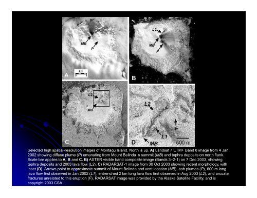
Selected high spatial-resolution images of Montagu Island. North is up. A) Landsat 7 ETM+ Band 8 image from 4 Jan<br />
2002 showing diffuse plume (P) emanating from Mount Belinda s summit (MB) and tephra deposits on north flank.<br />
Scale bar applies to A, B and C. B) ASTER visible band composite image (Bands 3–2-1) on 7 Dec 2003, showing<br />
tephra deposits and 2003 lava flow (L2). C) RADARSAT-1 image from 30 Oct 2003 showing recent morphology, with<br />
inset (D). Arrows point to approximate summit of Mount Belinda and vent location (MB), ash plumes (P), 600 m long<br />
lava flow first observed in Jan 2002 (L1), entrenched 2 km long lava flow first observed in Aug 2003 (L2), and arcuate<br />
fractures unrelated to this eruption (F). RADARSAT image was provided by the Alaska <strong>Satellite</strong> Facility, and is<br />
copyright 2003 CSA