Demographic Profile of Seniors in PSA 1-A - Detroit Area Agency on ...
Demographic Profile of Seniors in PSA 1-A - Detroit Area Agency on ...
Demographic Profile of Seniors in PSA 1-A - Detroit Area Agency on ...

You also want an ePaper? Increase the reach of your titles
YUMPU automatically turns print PDFs into web optimized ePapers that Google loves.
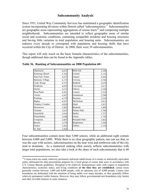
Subcommunity Analysis<br />
S<str<strong>on</strong>g>in</str<strong>on</strong>g>ce 1951, United Way Community Services has ma<str<strong>on</strong>g>in</str<strong>on</strong>g>ta<str<strong>on</strong>g>in</str<strong>on</strong>g>ed a geographic identificati<strong>on</strong><br />
system <str<strong>on</strong>g>in</str<strong>on</strong>g>corporat<str<strong>on</strong>g>in</str<strong>on</strong>g>g divisi<strong>on</strong>s with<str<strong>on</strong>g>in</str<strong>on</strong>g> <str<strong>on</strong>g>Detroit</str<strong>on</strong>g> called “subcommunities.” Subcommunities<br />
are geographic areas represent<str<strong>on</strong>g>in</str<strong>on</strong>g>g aggregati<strong>on</strong>s <str<strong>on</strong>g>of</str<strong>on</strong>g> census tracts 10 and compris<str<strong>on</strong>g>in</str<strong>on</strong>g>g multiple<br />
neighborhoods. Subcommunities are <str<strong>on</strong>g>in</str<strong>on</strong>g>tended to reflect geographic areas <str<strong>on</strong>g>of</str<strong>on</strong>g> similar<br />
social and ec<strong>on</strong>omic c<strong>on</strong>diti<strong>on</strong>s, c<strong>on</strong>ta<str<strong>on</strong>g>in</str<strong>on</strong>g><str<strong>on</strong>g>in</str<strong>on</strong>g>g compatible residents and hous<str<strong>on</strong>g>in</str<strong>on</strong>g>g structures<br />
and hav<str<strong>on</strong>g>in</str<strong>on</strong>g>g little variati<strong>on</strong> <str<strong>on</strong>g>in</str<strong>on</strong>g> total populati<strong>on</strong> and hous<str<strong>on</strong>g>in</str<strong>on</strong>g>g units. Subcommunities are<br />
redrawn every decade to corresp<strong>on</strong>d with populati<strong>on</strong> and hous<str<strong>on</strong>g>in</str<strong>on</strong>g>g shifts that have<br />
occurred with<str<strong>on</strong>g>in</str<strong>on</strong>g> the City <str<strong>on</strong>g>of</str<strong>on</strong>g> <str<strong>on</strong>g>Detroit</str<strong>on</strong>g>. In 2000, there were 39 subcommunities.<br />
This report will <strong>on</strong>ly touch <strong>on</strong> the basic formula characteristics <str<strong>on</strong>g>of</str<strong>on</strong>g> the subcommunities,<br />
though additi<strong>on</strong>al data can be found <str<strong>on</strong>g>in</str<strong>on</strong>g> the Appendix tables.<br />
Table 36. Rank<str<strong>on</strong>g>in</str<strong>on</strong>g>g <str<strong>on</strong>g>of</str<strong>on</strong>g> Subcommunities <strong>on</strong> 2000 Populati<strong>on</strong> 60+<br />
Mackenzie 6,015 Belle Isle 3,180<br />
Ketter<str<strong>on</strong>g>in</str<strong>on</strong>g>g/ Butzel 5,762 Central 3,125<br />
State Fair/ Nolan 5,637 Airport 2,842<br />
Harm<strong>on</strong>y Village 5,175 Cerveny 2,768<br />
Cody/ Rouge 4,757 Redford 2,678<br />
Pembroke 4,692 University 2,613<br />
Durfee 4,515 Osborn 2,350<br />
Rosa Parks 4,501 C<strong>on</strong>nor 2,322<br />
Vernor 4,387 Grandm<strong>on</strong>t 2,290<br />
Persh<str<strong>on</strong>g>in</str<strong>on</strong>g>g 4,379 Boynt<strong>on</strong> 2,224<br />
Bagley 4,297 McNichols 2,013<br />
Chadsey/ C<strong>on</strong>d<strong>on</strong> 4,024 Mack 1,821<br />
Downtown 3,905 Burbank 1,809<br />
Tireman 3,833 Palmer Park 1,788<br />
Greenfield 3,814 Denby 1,757<br />
W<str<strong>on</strong>g>in</str<strong>on</strong>g>terhalter 3,648 Chene 1,738<br />
Evergreen 3,607 Rosedale Park 1,662<br />
Brooks 3,379 Brightmoor 1,396<br />
F<str<strong>on</strong>g>in</str<strong>on</strong>g>ney 3,281 Jeffries 1,154<br />
St. Jean 3,262<br />
Four subcommunities c<strong>on</strong>ta<str<strong>on</strong>g>in</str<strong>on</strong>g> more than 5,000 seniors, while an additi<strong>on</strong>al eight c<strong>on</strong>ta<str<strong>on</strong>g>in</str<strong>on</strong>g><br />
between 4,000 and 5,000. While there is no clear geographic pattern, <strong>on</strong>e can see that, as<br />
was the case with sectors, subcommunities <strong>on</strong> the near west and northwest side <str<strong>on</strong>g>of</str<strong>on</strong>g> the city<br />
tend to dom<str<strong>on</strong>g>in</str<strong>on</strong>g>ate. As a numerical rank<str<strong>on</strong>g>in</str<strong>on</strong>g>g <str<strong>on</strong>g>of</str<strong>on</strong>g>ten merely reflects subcommunities with<br />
larger total populati<strong>on</strong>s, we also take a look at the share <str<strong>on</strong>g>of</str<strong>on</strong>g> each subcommunity that is 60<br />
10 Census tracts are small, relatively permanent statistical subdivisi<strong>on</strong>s <str<strong>on</strong>g>of</str<strong>on</strong>g> a county or statistically equivalent<br />
entity, del<str<strong>on</strong>g>in</str<strong>on</strong>g>eated for data presentati<strong>on</strong> purposes by a local group <str<strong>on</strong>g>of</str<strong>on</strong>g> census data users <str<strong>on</strong>g>in</str<strong>on</strong>g> accordance with<br />
U.S. Census Bureau guidel<str<strong>on</strong>g>in</str<strong>on</strong>g>es. Designed to be relatively homogeneous units with respect to populati<strong>on</strong><br />
characteristics, ec<strong>on</strong>omic status, and liv<str<strong>on</strong>g>in</str<strong>on</strong>g>g c<strong>on</strong>diti<strong>on</strong>s at the time they are established, census tracts<br />
generally c<strong>on</strong>ta<str<strong>on</strong>g>in</str<strong>on</strong>g> between 1,000 and 8,000 people, with an optimum size <str<strong>on</strong>g>of</str<strong>on</strong>g> 4,000 people. Census tract<br />
boundaries are del<str<strong>on</strong>g>in</str<strong>on</strong>g>eated with the <str<strong>on</strong>g>in</str<strong>on</strong>g>tenti<strong>on</strong> <str<strong>on</strong>g>of</str<strong>on</strong>g> be<str<strong>on</strong>g>in</str<strong>on</strong>g>g stable over many decades, so they generally follow<br />
relatively permanent visible features. However, they may follow governmental unit boundaries (city limits)<br />
and other <str<strong>on</strong>g>in</str<strong>on</strong>g>visible features <str<strong>on</strong>g>in</str<strong>on</strong>g> some <str<strong>on</strong>g>in</str<strong>on</strong>g>stances.<br />
26