Geophysical data acquisition - OGS
Geophysical data acquisition - OGS
Geophysical data acquisition - OGS

You also want an ePaper? Increase the reach of your titles
YUMPU automatically turns print PDFs into web optimized ePapers that Google loves.
Field operations showed a normal course, so it has been possible to get all the<br />
targets:<br />
Cerro F.- service well: seismic while drilling <strong>acquisition</strong> with ENI-AGIP. 55 channel<br />
seismic survey. Main target top of cretaceous platform, deviation geometry control,<br />
refraction survey for static corrections, indications on well casing operations.<br />
Monte A.- service well: seismic while drilling <strong>acquisition</strong> with ENI AGIP. 60<br />
channel seismic survey. Main target top of carbonate platform, deviation geometry<br />
control, refraction survey for static corrections, indications on well casing<br />
operations, receivers pattern test.<br />
Cerro F.- research well: seismic while drilling <strong>acquisition</strong> with ENI-AGIP in the<br />
frame of a research project. Down-hole instrumentation testing.<br />
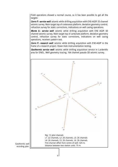
Geothermic service well: seismic while drilling <strong>acquisition</strong> service in Larderello<br />
area for ENEL. Well geometry tracing. 164 channel pseudo-3D seismic survey.<br />
Geothermic well<br />
recording plan.<br />
Rig: 12 pilot channels<br />
L1 :22 channels, L2: 26 channels, L3: 26 channels<br />
L4: 26 channels, L5: 26 channels, L6: 26 channels<br />
First channel offset from centre of well: 325 m,<br />
distance between two station units: 75 m.<br />
6