Geophysical data acquisition - OGS
Geophysical data acquisition - OGS
Geophysical data acquisition - OGS

You also want an ePaper? Increase the reach of your titles
YUMPU automatically turns print PDFs into web optimized ePapers that Google loves.
At the end of the year, we started a doctoral Program in Polar Sciences (applied to<br />
polar continental margin evolution) in cooperation with the University of Siena.<br />
Michele Rebesco hosted the Workshop “Seismic expression of contourites<br />
and related deposits” in the framework of the IUGS-UNESCO International<br />
Geological Correlation Programme n. 432 (Contourites, Bottom Currents and<br />
Palaeocirculation).<br />
We illustrate below the major scientific results achieved in the year 2000.<br />
Joint Italian/Australian Marine Geoscience Expedition<br />
to the George V Land Region of East Antarctica<br />
(Wilkes Land Glacial History, WEGA project)<br />
G. BRANCOLINI<br />
M. BUSETTI<br />
C. PELOS<br />
L. SORMANI<br />
R. VIDMAR<br />
A collaborative Italian PNRA/Australian AGSO-Antarctic CRC marine geoscience<br />
research voyage to the George V Land sector of the East Antarctic continental<br />
margin was carried out in February-March, 2000, on board the of the RV Tangaroa.<br />
A total of 1827 km of multi-channel seismic <strong>data</strong> (2 x 150 cu.in. GI airguns, 600 m<br />
streamer length), 562 km of Chirper (2.5-7kHz and 8-21 kHz transducers, 1000m<br />
armoured cable) sonar <strong>data</strong>, 11 gravity cores, 28 piston cores, 18 surface grabs and<br />
11 short trigger cores were collected on the voyage. Water profile (CTD)<br />
measurements and water samples were collected at nine stations and seabed<br />
bottom photographs were made at 11 stations.<br />
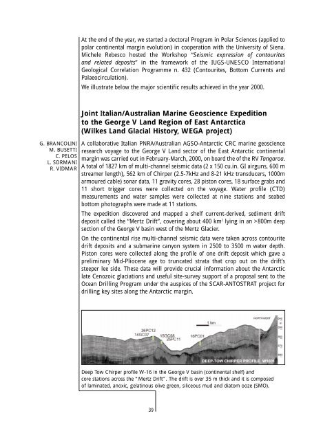
The expedition discovered and mapped a shelf current-derived, sediment drift<br />
deposit called the “Mertz Drift”, covering about 400 km 2 lying in an >800m deep<br />
section of the George V basin west of the Mertz Glacier.<br />
On the continental rise multi-channel seismic <strong>data</strong> were taken across contourite<br />
drift deposits and a submarine canyon system in 2500 to 3500 m water depth.<br />
Piston cores were collected along the profile of one drift deposit which gave a<br />
preliminary Mid-Pliocene age to truncated strata that crop out on the drift’s<br />
steeper lee side. These <strong>data</strong> will provide crucial information about the Antarctic<br />
late Cenozoic glaciations and useful site-survey support of a proposal sent to the<br />
Ocean Drilling Program under the auspices of the SCAR-ANTOSTRAT project for<br />
drilling key sites along the Antarctic margin.<br />
Deep Tow Chirper profile W-16 in the George V basin (continental shelf) and<br />
core stations across the “Mertz Drift”. The drift is over 35 m thick and it is composed<br />
of laminated, anoxic, gelatinous olive green, siliceous mud and diatom ooze (SMO).<br />
39