Geophysical data acquisition - OGS
Geophysical data acquisition - OGS
Geophysical data acquisition - OGS

Create successful ePaper yourself
Turn your PDF publications into a flip-book with our unique Google optimized e-Paper software.
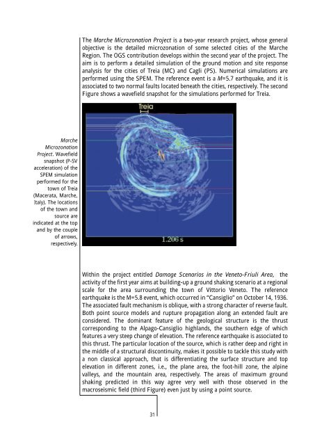
The Marche Microzonation Project is a two-year research project, whose general<br />
objective is the detailed microzonation of some selected cities of the Marche<br />
Region. The <strong>OGS</strong> contribution develops within the second year of the project. The<br />
aim is to perform a detailed simulation of the ground motion and site response<br />
analysis for the cities of Treia (MC) and Cagli (PS). Numerical simulations are<br />
performed using the SPEM. The reference event is a M=5.7 earthquake, and it is<br />
associated to two normal faults located beneath the cities, respectively. The second<br />
Figure shows a wavefield snapshot for the simulations performed for Treia.<br />
Marche<br />
Microzonation<br />
Project. Wavefield<br />
snapshot (P-SV<br />
acceleration) of the<br />
SPEM simulation<br />
performed for the<br />
town of Treia<br />
(Macerata, Marche,<br />
Italy). The locations<br />
of the town and<br />
source are<br />
indicated at the top<br />
and by the couple<br />
of arrows,<br />
respectively.<br />
Within the project entitled Damage Scenarios in the Veneto-Friuli Area, the<br />
activity of the first year aims at building-up a ground shaking scenario at a regional<br />
scale for the area surrounding the town of Vittorio Veneto. The reference<br />
earthquake is the M=5.8 event, which occurred in “Cansiglio” on October 14, 1936.<br />
The associated fault mechanism is oblique, with a strong character of reverse fault.<br />
Both point source models and rupture propagation along an extended fault are<br />
considered. The dominant feature of the geological structure is the thrust<br />
corresponding to the Alpago-Cansiglio highlands, the southern edge of which<br />
features a very steep change of elevation. The reference earthquake is associated to<br />
this thrust. The particular location of the source, which is rather deep and right in<br />
the middle of a structural discontinuity, makes it possible to tackle this study with<br />
a non classical approach, that is differentiating the surface structure and top<br />
elevation in different zones, i.e., the plane area, the foot-hill zone, the alpine<br />
valleys, and the mountain area, respectively. The areas of maximum ground<br />
shaking predicted in this way agree very well with those observed in the<br />
macroseismic field (third Figure) even just by using a point source.<br />
31