Geophysical data acquisition - OGS
Geophysical data acquisition - OGS
Geophysical data acquisition - OGS

You also want an ePaper? Increase the reach of your titles
YUMPU automatically turns print PDFs into web optimized ePapers that Google loves.
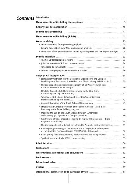
Contents<br />
Introduction . . . . . . . . . . . . . . . . . . . . . . . . . . . . . . . . . . . . . . . . . . . . . . . . . . . . . . . . . . . . . . . . . . . . . . . . . . . . . 1<br />
Measurements while drilling (<strong>data</strong> <strong>acquisition</strong>) . . . . . . . . . . . . . . . . . . . . . . . . . . . . . . . . . . . . . . . . . . 5<br />
<strong>Geophysical</strong> <strong>data</strong> <strong>acquisition</strong> . . . . . . . . . . . . . . . . . . . . . . . . . . . . . . . . . . . . . . . . . . . . . . . . . . . . . . . . . 10<br />
Seismic <strong>data</strong> processing . . . . . . . . . . . . . . . . . . . . . . . . . . . . . . . . . . . . . . . . . . . . . . . . . . . . . . . . . . . . . . . 17<br />
Measurements while drilling (R & D) . . . . . . . . . . . . . . . . . . . . . . . . . . . . . . . . . . . . . . . . . . . . . . . . 23<br />
Wave modeling . . . . . . . . . . . . . . . . . . . . . . . . . . . . . . . . . . . . . . . . . . . . . . . . . . . . . . . . . . . . . . . . . . . . . . . . 25<br />
• Seismic modeling for exploration geophysics . . . . . . . . . . . . . . . . . . . . . . . . . . . . . . . . . . . . . . . . . . . 25<br />
• Ground penetrating radar for environmental problems . . . . . . . . . . . . . . . . . . . . . . . . . . . . . . . . . 28<br />
• Simulation of the ground motion caused by earthquakes and site response analysis . . . . 28<br />
Seismic inversion . . . . . . . . . . . . . . . . . . . . . . . . . . . . . . . . . . . . . . . . . . . . . . . . . . . . . . . . . . . . . . . . . . . . . . 33<br />
• The Cat-3D tomographic software . . . . . . . . . . . . . . . . . . . . . . . . . . . . . . . . . . . . . . . . . . . . . . . . . . . . . . 33<br />
• Joint 3D inversion of P, S and converted waves . . . . . . . . . . . . . . . . . . . . . . . . . . . . . . . . . . . . . . . . . 34<br />
• Time-lapse 3D tomography . . . . . . . . . . . . . . . . . . . . . . . . . . . . . . . . . . . . . . . . . . . . . . . . . . . . . . . . . . . . . 34<br />
• Seismic tomography for environmental studies . . . . . . . . . . . . . . . . . . . . . . . . . . . . . . . . . . . . . . . 36<br />
<strong>Geophysical</strong> interpretation . . . . . . . . . . . . . . . . . . . . . . . . . . . . . . . . . . . . . . . . . . . . . . . . . . . . . . . . . . . 38<br />
• Joint Italian/Australian Marine Geoscience Expedition to the George V<br />
Land Region of East Antarctica (Wilkes Land Glacial History, WEGA project) . . . . . . . . . . . . 39<br />
• Physical properties and seismic stratigraphy of ODP Leg 178 well sites,<br />
Antarctic Peninsula Pacific margin . . . . . . . . . . . . . . . . . . . . . . . . . . . . . . . . . . . . . . . . . . . . . . . . . . . . . . 40<br />
• Orbitally-Controlled rhythmic sedimentation in the Wild Drift,<br />
Antarctica (ODP Leg 188, Site 1165) . . . . . . . . . . . . . . . . . . . . . . . . . . . . . . . . . . . . . . . . . . . . . . . . . . . . . 42<br />
• Subsidence at the Cape Roberts drill sites (Ross Sea, Antarctica)<br />
from backstripping techniques . . . . . . . . . . . . . . . . . . . . . . . . . . . . . . . . . . . . . . . . . . . . . . . . . . . . . . . . . . 42<br />
• Cenozoic Evolution of the South Orkney Microcontinent . . . . . . . . . . . . . . . . . . . . . . . . . . . . . . . 45<br />
• Structure and Cenozoic evolution of the South America - Scotia plate<br />
boundary in the Tierra del Fuego region . . . . . . . . . . . . . . . . . . . . . . . . . . . . . . . . . . . . . . . . . . . . . . . . 46<br />
• Mapping the BSR on the South Shetland Margin (Antarctica)<br />
and assessing gas hydrate and free gas quantities . . . . . . . . . . . . . . . . . . . . . . . . . . . . . . . . . . . . . . 46<br />
• Gas hydrate physical properties imaging by multi-attribute analysis - Blake<br />
Ridge BSR Case History . . . . . . . . . . . . . . . . . . . . . . . . . . . . . . . . . . . . . . . . . . . . . . . . . . . . . . . . . . . . . . . . . . 48<br />
• Physical properties of sediment cores from the Antarctic continental margins . . . . . . . . . . 51<br />
• Backstripping modelling in the frame of the Stratigraphical Development<br />
of the Glaciated European Margin (STRATAGEM) - EU project . . . . . . . . . . . . . . . . . . . . . . . . . . . 52<br />
• Earth gravity field: measurements, <strong>data</strong> processing and interpretation . . . . . . . . . . . . . . . . . 53<br />
• Synthetic Aperture Radar (SAR) remote sensing . . . . . . . . . . . . . . . . . . . . . . . . . . . . . . . . . . . . . . . . . 55<br />
Administration . . . . . . . . . . . . . . . . . . . . . . . . . . . . . . . . . . . . . . . . . . . . . . . . . . . . . . . . . . . . . . . . . . . . . . . . . 56<br />
Publications . . . . . . . . . . . . . . . . . . . . . . . . . . . . . . . . . . . . . . . . . . . . . . . . . . . . . . . . . . . . . . . . . . . . . . . . . . . . 57<br />
Presentations at meetings and conventions . . . . . . . . . . . . . . . . . . . . . . . . . . . . . . . . . . . . . . . . 62<br />
Book reviews . . . . . . . . . . . . . . . . . . . . . . . . . . . . . . . . . . . . . . . . . . . . . . . . . . . . . . . . . . . . . . . . . . . . . . . . . . . 66<br />
Educational video . . . . . . . . . . . . . . . . . . . . . . . . . . . . . . . . . . . . . . . . . . . . . . . . . . . . . . . . . . . . . . . . . . . . . . 66<br />
Visitors . . . . . . . . . . . . . . . . . . . . . . . . . . . . . . . . . . . . . . . . . . . . . . . . . . . . . . . . . . . . . . . . . . . . . . . . . . . . . . . . . . 67<br />
International seminars in solid earth geophysics . . . . . . . . . . . . . . . . . . . . . . . . . . . . . . . . . . . 67<br />
5