Geophysical data acquisition - OGS
Geophysical data acquisition - OGS
Geophysical data acquisition - OGS

You also want an ePaper? Increase the reach of your titles
YUMPU automatically turns print PDFs into web optimized ePapers that Google loves.
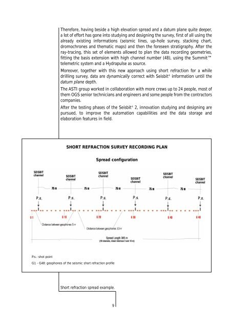
Therefore, having beside a high elevation spread and a datum plane quite deeper,<br />
a lot of effort has gone into studying and designing the survey, first of all using the<br />
already existing informations (seismic lines, up-hole survey, stacking chart,<br />
dromochrones and thematic maps) and then the foreseen stratigraphy. After the<br />
ray-tracing, this set of elements allowed to plan the <strong>data</strong> recording geometries,<br />
fitting the basis extension with high channel number (48), using the Summit<br />
telemetric system and a Hydrapulse as source.<br />
Moreover, together with this new approach using short refraction for a while<br />
drilling survey, <strong>data</strong> are dynamically correct with Seisbit ® information until the<br />
datum plane depth.<br />
The ASTI group worked in collaboration with more crews up to 24 people, most of<br />
them <strong>OGS</strong> senior technicians and engineers and some people from the contractors<br />
companies.<br />
After the testing phases of the Seisbit ® 2, innovation studying and designing are<br />
pursued, to improve the automation capabilities and the <strong>data</strong> storage and<br />
elaboration features in field.<br />
SHORT REFRACTION SURVEY RECORDING PLAN<br />
Spread configuration<br />
SEISBIT<br />
channel<br />
SEISBIT<br />
channel<br />
SEISBIT<br />
channel<br />
SEISBIT<br />
channel<br />
SEISBIT<br />
channel<br />
SEISBIT<br />
channel<br />
P.s.: shot point<br />
G1 - G48: geophones of the seismic short refraction profile<br />
Short refraction spread example.<br />
9