Geophysical data acquisition - OGS
Geophysical data acquisition - OGS
Geophysical data acquisition - OGS

You also want an ePaper? Increase the reach of your titles
YUMPU automatically turns print PDFs into web optimized ePapers that Google loves.
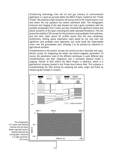
Transferring technology from the oil and gas industry to environmental<br />
application is a goal we pursued within the MICA Project, funded by the “Fondo<br />
Trieste”. We acquired a high-resolution 3D survey close to the Trieste airport, in an<br />
area where the city aqueduct has several catchment wells. The tomographic<br />
inversion and imaging of this <strong>data</strong> showed not only a good correlation with the<br />
available stratigraphy from 3 wells, but also remarked the significant vertical and<br />
lateral variations of the layers overlying the water-saturated formations. This fact<br />
proves the viability of 3D surveys for the protection of groundwater from pollution,<br />
and also their need: sparse 2D profiles would miss the area complexity;<br />
furthermore, drilling sparse exploration wells would be not only even less<br />
significant (and probably more expensive), but could break the impermeable<br />
covers over the groundwater pool, allowing it to be polluted by industrial or<br />
agricultural activities.<br />
Complementary to the seismic surveys, we carried out also a Georadar and a geoelectric<br />
survey, for integrating the elastic and electro-magnetic parameters. Of<br />
course, the penetration scale of the different techniques is quite different (but<br />
complementary), and their integration into a consistent physical model is<br />
ongoing. Partner of <strong>OGS</strong> within the MICA Project is GeoKarst, which is a<br />
geochemical company located in the Trieste Area Science Park. This company is<br />
complementing the <strong>OGS</strong> activity by analyzing the water origin and fluxes by<br />
measuring the isotopes it contains.<br />
The stratigraphy<br />
of 3 water well (above)<br />
matches the pre-stack<br />
depth migrated section<br />
(below) obtained by<br />
tomographic velocities<br />
in a high-resolution<br />
3D survey.<br />
37