teaching - Earth Science Teachers' Association
teaching - Earth Science Teachers' Association
teaching - Earth Science Teachers' Association

You also want an ePaper? Increase the reach of your titles
YUMPU automatically turns print PDFs into web optimized ePapers that Google loves.
<strong>teaching</strong><br />
EARTH<br />
SCIENCES<br />
From the Editor<br />
From the Chair<br />
ESTA Conference<br />
Extreme <strong>Earth</strong>: Climate<br />
Change Through Deep<br />
Time<br />
Lone Museum Curator<br />
Attends his First ESTA<br />
Conference<br />
Blakeney Esker<br />
Chartered Geographer<br />
(Teacher) – The Only<br />
Ongoing Professional<br />
Accreditation Linked to<br />
CPD in Geography<br />
ESTA Conference Field<br />
Report<br />
Geodiversity,<br />
Geoconservation<br />
and GeoValue<br />
A Sub-Mendip Field Trip!<br />
The <strong>Science</strong> of Global<br />
Warming<br />
Ecton Rises Again!<br />
Inspiring the New<br />
Generation to Opt for<br />
A level Geology<br />
News and Views<br />
ESTA Diary<br />
Reviews<br />
PEST – Issue 56<br />
Magazine of the EARTH SCIENCE TEACHERS’ ASSOCIATION<br />
Volume 31 ● Number 4, 2006 ● ISSN 0957-8005<br />
www.esta-uk.org
Teaching <strong>Earth</strong> <strong>Science</strong>s: Guide for Authors<br />
The Editor welcomes articles of any length and nature and on any topic related to<br />
<strong>Earth</strong> science education from cradle to grave. Please inspect back copies of TES,<br />
from Issue 26(3) onwards, to become familiar with the magazine house-style.<br />
Text<br />
Please supply the full text on disk or as an email attachment: Microsoft Word is<br />
the most convenient, but any widely-used wordprocessor is acceptable. Figures,<br />
tables and photographs must be referenced in the text, but sent as separate jpeg<br />
or tiff files (see below).<br />
Please use SI units throughout, except where this is inappropriate (in which case<br />
please include a conversion table). The first paragraph of each major article should<br />
not have a subheading but should either introduce the reader to the context of the<br />
article or should provide an overview to stimulate interest. This is not an abstract in<br />
the formal sense. Subsequent paragraphs should be grouped under sub-headings.<br />
To Advertise in<br />
<strong>teaching</strong><br />
EARTH<br />
SCIENCES<br />
<strong>teaching</strong><br />
EARTH<br />
SCIENCES<br />
References<br />
Please use the following examples as models<br />
(1) Articles<br />
Mayer, V. (1995) Using the <strong>Earth</strong> system for integrating the science curriculum.<br />
<strong>Science</strong> Education, 79(4), pp. 375-391.<br />
(2) Books<br />
McPhee, J. (1986 ) Rising from the Plains. New York: Fraux, Giroux & Strauss.<br />
(3) Chapters in books<br />
Duschl, R.A. & Smith, M.J. (2001) <strong>Earth</strong> <strong>Science</strong>. In Jere Brophy (ed), Subject-<br />
Specific Instructional Methods and Activities, Advances in Research on Teaching. Volume 8,<br />
pp. 269-290. Amsterdam: Elsevier <strong>Science</strong>.<br />
Figures<br />
Prepared artwork must be of high quality and submitted on paper or disk. Handdrawn<br />
and hand-labelled diagrams are not normally acceptable, although in some<br />
circumstances this is appropriate. Each figure must be submitted as a separate file.<br />
(not embedded in a Word file) Each figure must have a caption.<br />
Photographs<br />
Please submit colour or black-and-white photographs as originals. They are also<br />
welcomed in digital form on disk or as email attachments: .jpeg format is to be preferred.<br />
Please use one file for each photograph, to be at 300dpi. Each photograph<br />
must have a caption.<br />
Copyright<br />
There are no copyright restrictions on original material published in Teaching <strong>Earth</strong><br />
<strong>Science</strong>s if it is required for use in the classroom or lecture room. Copyright material<br />
reproduced in TES by permission of other publications rests with the original<br />
publisher. Permission must be sought from the Editor to reproduce original material<br />
from Teaching <strong>Earth</strong> <strong>Science</strong>s in other publications and appropriate acknowledgement<br />
must be given.<br />
All articles submitted should be original unless indicted otherwise and should<br />
contain the author’s full name, title and address (and email address where relevant).<br />
They should be sent to the Editor,<br />
Adrian Pickles<br />
Email: Adrian.mt@field-studies-council.org<br />
Tel: 01729 830331<br />
Magazine of the EARTH SCIENCE TEACHERS’ ASSOCIATION<br />
Volume 31 ● Number 4, 2006 ● ISSN 0957-8005<br />
Telephone<br />
Jane Ladson<br />
01142 303633<br />
www.esta-uk.org<br />
COPY DEADLINES<br />
TES 32.1 (PEST 57) 13 December 2006 for<br />
publication January/February 2007<br />
TES 32.2 (PEST 58) 20 February 2007 for<br />
publication April/May 2007<br />
TES 32.3 (PEST 59) 22 May 2007 for<br />
publication July/August 2007<br />
TES 32.4 (PEST 60) 25 September 2007 for<br />
publication November/December 2007<br />
WHERE IS PEST?<br />
PEST is printed as the<br />
centre 4 pages in<br />
Teaching <strong>Earth</strong> <strong>Science</strong>s.
Magazine of the EARTH SCIENCE TEACHERS’ ASSOCIATION<br />
Volume 31 ● Number 4, 2006 ● ISSN 0957-8005<br />
www.esta-uk.org<br />
TEACHING EARTH SCIENCES ● Volume 31 ● Number 4, 2006<br />
<strong>teaching</strong><br />
EARTH<br />
SCIENCES<br />
Teaching <strong>Earth</strong> <strong>Science</strong>s is published quarterly by<br />
the <strong>Earth</strong> <strong>Science</strong> Teachers’ <strong>Association</strong>. ESTA<br />
aims to encourage and support the <strong>teaching</strong> of<br />
<strong>Earth</strong> sciences, whether as a single subject or as<br />
part of science or geography courses.<br />
Full membership is £25.00; student and retired<br />
membership £12.50.<br />
Registered Charity No. 1005331<br />
Editor<br />
Adrian Pickles<br />
Tel: 01729 830331<br />
Email: adrian.mt@field-studies-council.org<br />
Advertising<br />
Jane Ladson<br />
Tel: 01142 303 633<br />
Email: janeladson@tiscali.co.uk<br />
Reviews Editor<br />
Dr. Denis Bates<br />
Tel: 01970 617667<br />
Email: deb@aber.ac.uk<br />
Council Officers<br />
Chairman<br />
Dawn Windley<br />
Tel: 01709 300600<br />
Email: dawn.windley@thomroth.ac.uk<br />
Secretary<br />
Susan Beale<br />
Email: beales.lowrow@virgin.net<br />
Membership Secretary<br />
Hamish Ross<br />
PO BOX 23672<br />
Edinburgh EH3 9XQ<br />
Tel: 0131 651 6410<br />
Email: hamish.ross@education.ed.ac.uk<br />
Treasurer<br />
Maggie Williams<br />
Email: maggiee.williams@tiscali.co.uk<br />
Primary Co-ordinator<br />
Niki Whitburn<br />
Email: farfalle@btinternet.com<br />
Secondary Co-ordinator<br />
Chris King<br />
Email: c.j.h.king@educ.keele.ac.uk<br />
Higher Education Co-ordinator<br />
Mike Tuke<br />
Email: miketuke@btinternet.com<br />
CONTENTS<br />
4 From the Editor<br />
5 Letters to the Editor<br />
7 From the Chair<br />
9 ESTA Conference<br />
10 Extreme <strong>Earth</strong>: Climate Change Through Deep<br />
Time<br />
Dr Howard Falcon-Lang<br />
13 Lone Museum Curator Attends his First ESTA<br />
Conference<br />
Jan Freedman<br />
15 Blakeney Esker<br />
Anna Jarrow<br />
17 Chartered Geographer (Teacher) – The Only<br />
Ongoing Professional Accreditation Linked to<br />
CPD in Geography<br />
Claire Wheeler<br />
18 The <strong>Science</strong> of Global Warming<br />
Professor Colin Prentice<br />
19 Geodiversity, Geoconservation<br />
and GeoValue<br />
Professor Peter W. Scott, Dr Robin Shail, Dr Clive Nicholas<br />
and David Roche<br />
22 ESTA Conference Field Report 1<br />
Burrington Combe, Mendips<br />
Peter Kennett<br />
23 ESTA Conference Field Report 2<br />
Tedbury Camp / Vallis Vale<br />
Rick Ramsdale<br />
24 Ecton Rises Again!<br />
Alastair Fleming<br />
26 Inspiring the New Generation to Opt for<br />
A level Geology<br />
Paul Douglas, Karl Gray, Chris King<br />
30 News and Views<br />
31 ESTA Diary<br />
34 Reviews<br />
PEST – Issue 56 – Building Stone Walks<br />
Visit our website at www.esta-uk.org<br />
Contributions to future issues of Teaching <strong>Earth</strong><br />
<strong>Science</strong>s will be welcomed and should be<br />
addressed to the Editor.<br />
Opinions and comments in this issue are the<br />
personal views of the authors and do not<br />
necessarily represent the views of the <strong>Association</strong>.<br />
Designed by Character Design<br />
Highridge, Wrigglebrook Lane, Kingsthorne<br />
Hereford HR2 8AW<br />
<strong>teaching</strong><br />
EARTH<br />
SCIENCES<br />
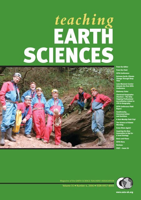
Front cover<br />
The intrepid cavers outside Goatchurch<br />
Cavern, Mendips. From L to R –<br />
Barry Cullimore, David Fuller, Geoff<br />
Nicholson, Ros Smith, Mike Tuke, Chris<br />
Binding (our cave leader), Dave Turner.<br />
© PETER KENNETT<br />
3 www.esta-uk.org
TEACHING EARTH SCIENCES ● Volume 31 ● Number 4, 2006<br />
Farewell and Thank You<br />
It has been a good summer, with another visit to the<br />
Big Green Gathering – fieldtrips and camping trips<br />
are so much more fun if it doesn’t rain, and this year,<br />
although there were a few wet moments, there was no<br />
flooding which meant plenty of time sitting round the<br />
camp fire, star gazing and sampling the occasional bottle<br />
of red amongst friends.<br />
Then back to work. The conference in Bristol was a<br />
good way to start the new term, getting back into the<br />
work routine. I don’t know how we managed to drink a<br />
pub dry – maybe they were running down stocks before<br />
the return of the ‘real students’.<br />
There was a range of talks and workshops, covering<br />
all interests from primary to HE. As in previous years, I<br />
found it difficult to choose between them and ended up<br />
moving from room to room. Speakers, workshop and<br />
fieldwork leaders and delegates have been invited to<br />
submit their write-ups for publication in this and<br />
future issues of Teaching <strong>Earth</strong> <strong>Science</strong>s. Keep a look out<br />
for them.<br />
Curriculum development and discussions continue<br />
at all levels, from the staff room to the ‘corridors of<br />
power’ in Westminster. Over the last few years, I have<br />
been involved in working groups looking at primary<br />
science, KS3 <strong>Science</strong> Strategy, KS4 and now Geology A<br />
level. Opinions vary, but the future looks bright.<br />
Coursework, assessment and content continue to excite<br />
and frustrate and new ideas abound.<br />
I was interested to hear more about the International<br />
Baccalaureate from Tony Grindrod, particularly as one<br />
of my local schools in St Albans is introducing this next<br />
year. Whether it turns out to be a success or not, it has<br />
already had the effect of involving parents and getting<br />
them discussing their children’s school work and future<br />
education. It is also motivating staff with the excitement<br />
of something new and different, rather than just more<br />
administration and yet more changes to their lessons.<br />
So, the debate continues.<br />
GCSE work at home is banned<br />
At the Labour conference in Manchester, the Education<br />
Secretary, Alan Johnson, said that GCSE maths<br />
coursework would be scrapped. Projects in other subjects<br />
would have to be completed in school under<br />
supervision. This is to avoid cheating; the Qualifications<br />
and Curriculum Authority (QCA) said that it<br />
has identified persistent evidence of abuse. One in 20<br />
parents admits doing their children’s coursework,<br />
which may account for 20-60% of the marks. So, less<br />
work for teachers in setting and marking coursework<br />
(unless they find themselves having to supervise<br />
coursework in school), less work for those parents<br />
who will no longer have coursework to do (unless<br />
they choose to attend adult classes) – but maybe more<br />
revision and exam nerves for those who rely on doing<br />
their best under exam conditions?<br />
Pink Diamonds<br />
As a gemmologist and author of books on gemstones,<br />
my eye is often caught by articles on gemstones and<br />
particularly the unusual, the biggest or the best. I was<br />
interested to read that the largest collection of pink diamonds<br />
in the world went on sale in London on 28 September.<br />
65 gems were shown to potential buyers at a<br />
secret location in Mayfair. The pink diamonds are selling<br />
for more than £200,000 per carat (carat = 0.2g). The<br />
diamond collection is from the Argyle Mine in Western<br />
Australia. I also mention gemstones as a reminder about<br />
careers, so that when you hear an occasional student,<br />
friend or colleague mistakenly associating geology or<br />
mining with ‘boring grey rocks’ or ‘only oil rigs and<br />
things’ remind them that mineralogy and gemmology<br />
are also worthwhile and often well-paid careers and<br />
they could be handling some of the most attractive and<br />
valuable rocks on <strong>Earth</strong>!<br />
Graduate Skills and Recruitment Report<br />
It seems that the wide range of <strong>Earth</strong> science careers<br />
are seldom, if ever, mentioned at schools as worthwhile<br />
or well-paid careers. This lack of awareness is<br />
often duplicated in HE/FE. The <strong>Earth</strong> <strong>Science</strong> Education<br />
Forum for England and Wales (ESEF(EW)) is<br />
particularly concerned about the lack of <strong>Earth</strong> science<br />
teachers and the lack of qualified <strong>Earth</strong> scientists. Following<br />
on from the conference report ‘Improving the<br />
Effectiveness of Education Resources for <strong>Earth</strong> <strong>Science</strong><br />
and Industry’, ESEF(EW) has set up a working<br />
group to look at workforce issues (www.esef.org.uk or<br />
contact me for further details).<br />
The lack of graduate skills and recruitment issues has<br />
also been highlighted in other areas. The City of London<br />
Corporation and the Financial Services Skills<br />
Council surveyed 25 banking, insurance, asset management<br />
and legal, accounting and maritime services firms<br />
(but not geological firms). Results indicated that British<br />
graduates are missing out on top City jobs because they<br />
do not have the skills of their overseas counterparts.<br />
Employers recruit up to one in five foreign youngsters,<br />
because they are more mature and better prepared for<br />
the workplace, speak more languages and have greater<br />
working experience. In some companies, the figure is as<br />
much as 50%. <strong>Earth</strong> scientists are a global workforce<br />
and these figures should be heeded as a warning, but<br />
also as an incentive to train more <strong>Earth</strong> scientists for the<br />
global market.<br />
And so it is farewell<br />
I was pleased to report to the AGM at Conference:<br />
www.esta-uk.org<br />
4
TEACHING EARTH SCIENCES ● Volume 31 ● Number 4, 2006<br />
‘With time spent on commissioning articles and promoting<br />
the magazine there has been plenty of good<br />
copy and there is no longer the need to accept ‘anything<br />
that is offered’ for publication. This also means that the<br />
magazine can be better tailored to the readers’ interests.<br />
Research has been carried out to identify options for<br />
introducing colour printing while retaining the good<br />
reputation and quality of TES, but finances have been<br />
such that no action has been taken. Now that the backlog<br />
is cleared, and in order to continue to publish four<br />
issues a year, it is essential that copy deadlines (printed<br />
inside the front cover of each issue) are adhered to.<br />
I would like Council to note its vote of thanks to<br />
Denis Bates for his work with book reviews. I would<br />
also ask Council to give its thanks to Ian Ray who has<br />
handled advertising and inserts and Maggie Williams<br />
for providing diary information.’<br />
And finally, I would also like to thank everyone who<br />
has helped me over the last three years; contributing<br />
articles, proof reading and giving valuable feedback.<br />
I have enjoyed doing the job as editor although it<br />
has been time consuming and on occasions quite frustrating,<br />
but it has also been an honour and at times a<br />
pleasure.<br />
And so after 16 issues of TES, it is farewell from me<br />
as Adrian Pickles takes over the reins.<br />
Cally Oldershaw<br />
Email: cally.oldershaw@btopenworld.com<br />
Welcome<br />
Adrian Pickles, Head of Centre at Malham Tarn, is an <strong>Earth</strong> scientist, orienteer and educationalist with 30 years’<br />
experience of helping people navigate their way in the world.<br />
Contact details:<br />
Adrian Pickles<br />
Head of Centre, Malham Tarn Field Centre<br />
Settle, North Yorkshire BD24 9PU<br />
Tel: 01729 830331<br />
Email: adrian.mt@field-studies-council.org<br />
Letters to the Editor<br />
Dear Editor<br />
There is a potential shortage of professional geologists.<br />
This is a recurring theme when talking to practising geoscientists<br />
and <strong>Earth</strong> science academics, and occasionally<br />
it is backed up by concrete figures. In July of this year a<br />
report by the British Geophysical <strong>Association</strong> warns of a<br />
chronic shortage of geophysics graduates (Education<br />
Guardian; 25/07/06). Geophysicists are required in a<br />
wide range of <strong>Earth</strong> science disciplines such as climate<br />
change, radioactive waste disposal, energy supply and<br />
global water resources. “The population in the industry is<br />
ageing while the number of students entering university to read<br />
geophysical science is falling and courses are being discontinued. If<br />
current rates of decline continue there will be no geophysics undergraduates<br />
by 2030. The problem is global.”<br />
This is not a new situation. In 2004 the Institute of<br />
Physics bemoaned the relentless decline in A level<br />
physics students, and this affects not only <strong>Earth</strong> science,<br />
also engineering and a host of scientific disciplines,<br />
many of them in hospitals. Dr Julia King, the chief<br />
executive of the Institute said that, “Physics is in decline<br />
and other subjects, such as media studies and art, are increasingly<br />
popular despite the poor career prospects they offer. It’s a<br />
crazy situation.” Last year, Lord May of Oxford, the President<br />
of the Royal Society commented, “We are still facing<br />
a crisis in physics, maths and chemistry at A level. Compared<br />
to 1991, the overall numbers of A level entries in 2005<br />
were 12.1% higher. But entries in physics were 35.2% lower,<br />
entries in mathematics were 21.5% lower, and entries in chemistry<br />
were 12.6% lower. We will not be able to meet the needs of<br />
employers and enjoy a strong economy in the UK in the future<br />
if we do not have sufficient numbers of people trained and qualified<br />
in science and mathematics,”<br />
This is being written one week before the 2006<br />
A level results are announced, but I would be surprised<br />
if this trend is not continuing. In 2004 there were<br />
28,698 A level entries for physics, 37,254 for chemistry<br />
and 58,508 for maths, all declining. For comparison the<br />
entries for psychology were 46,933; media studies<br />
26,894 and sociology 25,571 and all increasing. The<br />
total entries in all subjects in 2004 were 766,247. The<br />
solutions offered are that the ‘at-risk’ subjects must be<br />
made more attractive to students in the market place,<br />
then more 16 year olds will choose them.<br />
It is time the whole question of the free market and<br />
complete freedom of choice in 16-19 education is<br />
appraised. A level courses are increasingly taught in<br />
Continued on page 6<br />
5 www.esta-uk.org
TEACHING EARTH SCIENCES ● Volume 31 ● Number 4, 2006<br />
Further Education and Sixth Form Colleges. They are<br />
in competition with each other for students, and likewise<br />
within the colleges, individual faculties and<br />
departments are also often in competition. If a subject<br />
is losing students, to maintain staff in employment<br />
you may have to offer new subjects. The student perception<br />
and that of many teachers is that maths,<br />
physics, chemistry along with foreign languages are<br />
‘hard’ subjects whereas the newer subjects are not<br />
only easier but; ‘sound interesting’. There is evidence<br />
that students tend to choose ‘easier’ subjects. If a college<br />
tries to restrict student choice or decides not to<br />
offer a subject because it does not believe it has a place<br />
on the curriculum, it risks losing the student to a rival<br />
college. Targets are all about total student numbers<br />
and pass rates, not about curricular content. It is a<br />
crazy situation.<br />
A level geology is a small subject with entries around<br />
2,000 - 3,000 mark, and yet probably provides a significant<br />
number of professional geologists. It is kept going<br />
in schools and colleges by a band of enthusiasts, but like<br />
all sciences it is expensive to deliver, requiring laboratory<br />
space, and cost is another consideration in our<br />
market orientated further education system.<br />
Bill Groves<br />
billgroves300@btinternet.com<br />
Also printed in the Newsletter of the Black<br />
Country Geological Society, August 2006<br />
Dear Editor<br />
“I tell my friends, ‘I’m gay!’” These are the words of a<br />
Past Master Cutler of Sheffield, the late Raymond<br />
Douglas. He would then bring down the raised eyebrows<br />
by saying, “Gay is a lovely little English word that<br />
means happy and carefree, and I refuse to have it highjacked<br />
by a certain section of the community.”<br />
In a similar way, in response to Antony Wyatt’s article<br />
on creationism (Teaching <strong>Earth</strong> <strong>Science</strong>s, 31.3), I can<br />
say that I am a creationist. In case any geological eyebrows<br />
are on their way up, I should explain that what I<br />
mean by the term is that, for me, God did it, and goes<br />
on doing it. My role, as a geologist, is to enjoy finding<br />
out how he did it and how long it took him. Fortunately<br />
for the geological profession, there is still a lot more to<br />
be found out than is contained in the first few verses of<br />
Genesis!<br />
In common with other Christians who are also scientists<br />
(and there are many among the membership of<br />
ESTA), I have had to work out my own position over<br />
the years and be ready to consider fresh ideas as I go. For<br />
me, there is no major problem – the Bible and science<br />
are addressing different aspects of human experience.<br />
We were never meant to learn all our biology and geology<br />
from a text whose main purpose is to point to a creator.<br />
The Bible is also intended to show that<br />
humankind is not what that creator would have it to be.<br />
However, he has also provided the remedy in sending<br />
Jesus Christ as our saviour. (Incidentally, chemists and<br />
physicists have less of a problem, since the Bible has little<br />
to say about these sciences).<br />
I can understand where the “creationists” (i.e. literalists)<br />
are coming from. In accepting the Bible as God’s<br />
Word, they fear that it will be diminished if we view different<br />
bits of it in a different way. Rather than accept, as<br />
I do, that some is poetry, some is real history, some allegory<br />
and much (especially the New Testament) is literally<br />
true, they opt for the simplistic solution of having<br />
every word as literally true, contradictions and all. They<br />
forget that the Bible itself says that the Holy Spirit<br />
guides us in its interpretation, and makes it all relevant<br />
to our needs (but not as a science textbook).<br />
Antony asks the question, “Does it matter?” and I<br />
agree with him that it does, which I can perhaps illustrate<br />
with a few anecdotes of my own.<br />
I once went to a meeting addressed by an eminent<br />
Professor of Biology who called himself a “scientific<br />
creationist”. I was not qualified to comment on the<br />
accuracy of his biological arguments, opposing evolution<br />
(me, I dropped Biology at 14!), but when he<br />
started on supposed geological evidence, my hackles<br />
rose. He talked about radioisotopic dating, but only<br />
mentioned the C14 method and not those techniques<br />
that are of more use to geologists. He was at pains to<br />
point out that if the graph were in error in one direction,<br />
then the resultant date would be an overestimate:<br />
he totally failed to discuss what would happen if the<br />
equally likely error were to occur in the other direction!<br />
The rest of his talk was just as full of inconsistencies<br />
and I became annoyed enough to tackle him<br />
afterwards over a cup of tea, accusing him of taking my<br />
beloved science back to the 18th Century! At that time,<br />
I had a number of sixth formers who were enquiring<br />
about Christianity and I had nearly invited them to the<br />
meeting – I am glad I didn’t!<br />
The Professor and I agreed that the most vital thing<br />
about our shared faith was the centrality of Jesus<br />
Christ and our personal response to him, but we<br />
clearly differed strongly on “creationism” As we<br />
parted, he called me a “theistic evolutionist” – I don’t<br />
think he was being rude!<br />
I gather that some devout Moslems take a similarly<br />
literalistic line, but I knew little of a modern Jewish<br />
viewpoint until I heard the comments on the radio of<br />
Lord Robert Winston, the eminent fertility expert. He<br />
is a practising Jew, and stated that Jews are quite happy<br />
in seeking scientific explanations for miracles such as<br />
the parting of the Red Sea. The miracle to him would<br />
then be in the timing of God’s actions rather than in<br />
the method.<br />
Antony considers the influence of “creationist”<br />
beliefs on science, and I too would express some anxi-<br />
www.esta-uk.org<br />
6
TEACHING EARTH SCIENCES ● Volume 31 ● Number 4, 2006<br />
ety. Is the growing publicity about “creationism” and<br />
the underlying confusion which it sows another factor<br />
in the perceived drift away from science in our schools,<br />
in favour of “arts” subjects?<br />
I have recently been made aware of the influence of<br />
literalistic beliefs on politics too. My wife and I were<br />
able to visit Israel/Palestine during a relatively peaceful<br />
time, two years ago. One day, we entered into a<br />
lunchtime conversation with a group of English people<br />
wearing badges proclaiming “Friends of Israel” or<br />
something similar. These were Christians, mainly middle<br />
aged ladies, who were adamant that God had given<br />
the land to the Israelis for all time, based on an Old Testament<br />
passage, and taking no notice of Jesus’ <strong>teaching</strong><br />
in the New. Their leader was a charismatic man, whose<br />
following clearly adored him. In order to counteract his<br />
seven day creation diatribe, my wife asked him if he<br />
knew any geology. He then claimed to be qualified in<br />
palaeontology, astronomy, archaeology, etc, but sadly<br />
was called away by one of his disciples before we could<br />
test the evidence!<br />
We were later reminded that American policy in the<br />
Middle East is, at least in part, dictated by the President<br />
looking over his shoulder at his electorate, not it would<br />
seem, the relatively small Jewish vote, but the much<br />
larger and more vociferous “Christian Right”. If these<br />
people are as literalistic as the folk we met, it may<br />
explain why, to many of us, the U.S. treatment of the<br />
situation in Israel/Palestine seems unbalanced.<br />
Oops! I have erred and strayed from the geological<br />
way, like a lost sheep! I must now attend to those things<br />
that I have left undone and cast myself on the mercy of<br />
the editor as to how much of the above gets published!!<br />
Peter Kennett<br />
peter.kennett@tiscali.co.uk<br />
Greetings to ESTA Members<br />
Iwrite this piece having just returned from an actionpacked,<br />
fun-filled and inspiring weekend – our<br />
Annual Course and Conference which this year was<br />
held at Bristol University. Here I was duly elected<br />
ESTA Chairman (person?). As a practising A level<br />
Geology teacher I am not completely new to ESTA<br />
Council. Some of you may remember me as ESTA Secretary<br />
(1999-2003). I thoroughly enjoyed my involvement<br />
with ESTA then and I am honoured to be serving<br />
on Council once more and looking forward to an exciting<br />
and fulfilling term of office.<br />
The Bristol Course and Conference was a great success<br />
in every respect, with over 120 people being<br />
involved over the three days. The success was mostly<br />
due to our retiring Chairman Martin Whiteley, who as<br />
Conference Convenor, worked with a number of key<br />
aides to ensure that the whole event ran smoothly and<br />
efficiently. A programme of lectures and workshops<br />
formed the mainstay of the weekend and I’m delighted<br />
that some of these appear in this edition with others to<br />
follow in due course. These important contributions<br />
serve to both update us on current topics in <strong>Earth</strong> science<br />
and to provide inspiration for the classroom.<br />
A wealth of activities took place during the conference.<br />
Friday was the specific INSET day – with separate<br />
activities taking place for Primary (<strong>Earth</strong> <strong>Science</strong> to the<br />
Core), Key Stage 3 & 4 (Teaching the Dynamic <strong>Earth</strong>),<br />
Post-16 (Teaching for the Future) and, for the first time<br />
in a number of years, a workshop for Higher Education<br />
Staff specifically involved in Schools Liaison (Geo-<br />
<strong>Science</strong> in Transition). As a practising A level Geology<br />
teacher in Rotherham, South Yorkshire, I was lucky<br />
enough to experience “Lifting the Lid on Vulcanism” –<br />
the experimental modelling lecture and practical flume<br />
tank demonstrations from Jeremy Phillips (Bristol<br />
University), “Mining is (y)our future business” – Toby<br />
White (Leeds University), “Getting more out of Fossils”<br />
– Joe Botting (Natural History Museum), a fascinating<br />
and thought-provoking facilitated discussion on<br />
HE and Post-16 collaboration and the ever-excellent<br />
regular feature, the all-inspiring “Bring and Share” session<br />
which every year amazes me with the new ideas for<br />
<strong>teaching</strong> and learning it provides. Even after 10 years of<br />
<strong>Earth</strong> science <strong>teaching</strong> I am still discovering new and<br />
innovative ways to ensure our students have understood<br />
key concepts and ideas. Some of these will appear<br />
in later editions.<br />
Maggie Williams and I presented our own work in<br />
progress which was conceived at the A level workshop<br />
day in May this year – a PowerPoint encouraging students<br />
to choose Geology as a subject by making them<br />
aware of the different career paths it can lead to. This<br />
work is to be further developed for inclusion on both<br />
the ESTA (GEOTREX) website and the re-launched<br />
and updated Geological Society website. Any comments<br />
are invited, especially if you have student profiles<br />
we could use as examples.<br />
A wine reception (sponsored by Bristol University)<br />
was followed by the evening lecture given by Professor<br />
Mike Benton, Head of Department at Bristol on the<br />
popular topic of Mass Extinctions.<br />
Saturday dawned a little too soon for some participants<br />
who had been out in Clifton until the early hours,<br />
generally catching up on a year’s gossip and <strong>teaching</strong><br />
stories whilst enjoying some of the local curry houses<br />
and bars. One group of delegates arrived to find that the<br />
public house had “run out of beer”. The other geologists<br />
had obviously got there before them! Saturday<br />
morning included parallel sessions for Secondary and<br />
Continued on page 8<br />
7 www.esta-uk.org
TEACHING EARTH SCIENCES ● Volume 31 ● Number 4, 2006<br />
Primary teachers covering a range of topics including:<br />
Ancient Climates, Global Warming, the Jurassic Coast,<br />
the Mendips, Building Stones, ESEU, Fieldwork discussions,<br />
the International Baccalaureate and UKRIGS<br />
On-Line projects, whilst the afternoon allowed an<br />
introduction to the various fieldtrips that took place on<br />
Sunday. More on these will follow in future editions.<br />
Martin conducted the AGM with his usual efficiency<br />
before stepping down as Chairman. Martin has<br />
put in an incredible amount of effort in over the past six<br />
years, not only as a hardworking Chairman (2004-<br />
2006) but also as President (2001-2003), and ESTA<br />
indebted to him for establishing a number of important<br />
contacts and valuable sponsorships, and ensuring that<br />
the <strong>Association</strong> remains healthy and prosperous.<br />
Thanks Martin. Council reports from the AGM 2006<br />
can now be found on the ESTA website.<br />
As well as myself, other elections to Council were<br />
made at the AGM, including the re-appointment of<br />
both Maggie Williams as Treasurer and Susan Beale as<br />
Secretary, both for another 3 years in office. Thank you<br />
Maggie and Susan, your hard work is much appreciated.<br />
Thanks are also extended to Cally for agreeing to<br />
continue as Editor for this issue as she shows the “new<br />
editor” the ropes. In the meantime keep the contributions<br />
coming! The website is to be taken over by Peter<br />
Williams. David Whiteley, who has worked efficiently<br />
managing the website, and with Ben Church on the<br />
development of GEOTREX, is helping to ensure a<br />
smooth transition. Thank you David for helping to set<br />
up this excellent resource – how did we manage before<br />
this evolutionary event? As far as you the member is concerned,<br />
everything will be “business as normal” during<br />
this transition period. Advertising has been taken over<br />
by Jane Ladson whose contact details can be found in<br />
the front of the magazine. Do remember to pass on any<br />
details of anyone you think may want to advertise<br />
through us via Teaching <strong>Earth</strong> <strong>Science</strong>s or the website.<br />
Professor Jon Blundy’s talk on “Forecasting Volcanic<br />
Eruptions” concluded an excellent series of lectures and<br />
workshops and certainly provoked many questions<br />
which were still being discussed at the Conference<br />
Dinner and bar later in the evening.<br />
The Sunday morning fieldtrips included subterranean<br />
geology in Burrington Combe, local building<br />
stones in Bristol, Red Beds in Portishead and limestones<br />
in Vallis Vale. Thanks are extended to all fieldtrip<br />
leaders for increasing our knowledge of the geology of<br />
the Bristol area and helping us to consider possible student/pupil<br />
fieldwork activities.<br />
I certainly returned home full of enthusiasm and<br />
drive, armed with a number of key ideas to put into practice<br />
over the coming months. As usual the ESTA Conference<br />
proved to be an incredibly important INSET<br />
opportunity. If you missed this year, then make sure you<br />
check out the website, this issue and future editions of<br />
TES to capture the main essence of the weekend.<br />
Finally in my capacity as new Chair, may I take this<br />
opportunity to thank those of you who have renewed<br />
your ESTA subscriptions (hopefully with a Gift Aid)<br />
and to extend a particularly warm welcome to new<br />
members. Make a note in your diary now for the next<br />
Conference in Belfast, Northern Ireland, 14-16th September<br />
2007 with guaranteed awesome geological fieldwork.<br />
Dawn Windley<br />
ESTA Chair<br />
Contact details :<br />
Dr Dawn Windley<br />
Thomas Rotherham College<br />
Moorgate Road<br />
Rotherham<br />
South Yorkshire S60 2BE<br />
Email: dawn.windley@thomroth.ac.uk<br />
For a trial period, we are putting GEOTREX and<br />
past issues of Teaching <strong>Earth</strong> <strong>Science</strong>s under<br />
password protection on the ESTA website.<br />
Pssst… don’t forget…<br />
the word is… esta<br />
These resources have cost thousands of pounds<br />
to develop and we want to capture their value<br />
for ESTA members.<br />
www.esta-uk.org<br />
8
TEACHING EARTH SCIENCES ● Volume 31 ● Number 4, 2006<br />
ESTA Conference<br />
Primary INSET with John Reynolds<br />
Primary INSET acid test<br />
Toby White<br />
(University of Leeds)<br />
Joe Botting (Natural<br />
History Museum)<br />
Happy Primary teachers going home with their boxes!<br />
A group of ‘charismatics’ at worship!! (Mike Tuke persuaded all of<br />
the Post-16 group to climb on the bench and drop sycamore<br />
seeds. Some connection with graptolites, he said!)<br />
Conference Dinner in stately home<br />
Maggie Williams and Dawn Windley with<br />
their presentation on geological careers<br />
9 www.esta-uk.org
TEACHING EARTH SCIENCES ● Volume 31 ● Number 4, 2006<br />
Extreme <strong>Earth</strong>: Climate Change Through<br />
Deep Time<br />
DR HOWARD FALCON-LANG<br />
Climate change is nothing new. Over the billions of years of deep time, the <strong>Earth</strong>’s climate has<br />
fluctuated between periods of extreme warmth and cold. We can think of these extremes as<br />
experiments that nature has undertaken on our behalf. These experiments teach us how the<br />
<strong>Earth</strong>’s System works, and give us a better idea of the implications of our current meddling with<br />
planetary dynamics. In this article, I review some of the ways that geologists investigate ancient<br />
climate and give examples of what <strong>Earth</strong> was like during some climatic extremes.<br />
Figure 1<br />
The author with a<br />
Carboniferous<br />
fossil tree at<br />
Joggins, Nova<br />
Scotia, Canada.<br />
These fossils are<br />
remains of the<br />
earliest tropical<br />
rainforests.<br />
The study of ancient climates has a long history.<br />
One of the first palaeoclimatic investigations was<br />
made by Lun Sun in China way back in the<br />
twelfth century AD. He discovered a fossil forest of<br />
what he thought was petrified bamboo. As bamboo did<br />
not grow in that area, he argued that the climate must<br />
have been different when the rocks were formed.<br />
Palaeoclimatic research in a modern sense really began<br />
in the nineteenth century with the work of Charles<br />
Lyell. He sought to explain the mounting geological<br />
evidence for past climate change by means of observable<br />
natural causes rather than catastrophic events.<br />
Palaeoclimate toolbox<br />
So how can we study what the <strong>Earth</strong>’s climate was like<br />
millions of years ago? There are four main approaches<br />
to palaeoclimatology. One of the most useful for field<br />
geologists is sedimentary evidence. For example, tillites,<br />
the deposits of ancient glacial moraines, imply permanently<br />
freezing conditions; evaporites, such as gypsum<br />
and halite, suggest sufficient aridity to precipitate out<br />
salts; whereas laterites, iron-rich soil profiles, indicate<br />
very humid climates under which all other soil constituents<br />
were weathered away. In fact, ancient soils, or<br />
palaeosols, are one of the best sedimentary indicators of<br />
past climates as the global distribution of soil types is<br />
strongly controlled by temperature and rainfall, as well<br />
as bedrock.<br />
Another popular approach to palaeoclimate research<br />
involves fossils. Here, inferences are based on the<br />
known climate tolerance of the nearest living relative of<br />
the fossil in question. For example, crocodiles are today<br />
limited to environments with a mean annual temperature<br />
of 14°C. So when fossil crocodiles turned up in the<br />
Paleogene of northern Canada, geologists painted a picture<br />
of a subtropical Arctic Eden. Similarly, the widespread<br />
discovery of palm trees in the Tertiary London<br />
Clay points to England having had a much warmer climate<br />
in the distant past.<br />
Isotopes represent a third method for exploring<br />
ancient climates. One particularly useful isotope is oxygen,<br />
which comes in two main forms, light oxygen-16<br />
and heavy oxygen-18. Because light oxygen fits into the<br />
ice lattice more easily that heavy oxygen, their ratio in<br />
seawater is influenced by the size of the polar ice caps.<br />
In short, the larger the ice caps, the greater the proportion<br />
of heavy oxygen in seawater. Study of the oxygen<br />
isotopic ratio of marine foraminifera therefore provides<br />
one of the most detailed records of the various ice ages<br />
that have affected the Quaternary.<br />
Computer models represent a final palaeoclimatic<br />
technique. The Met Office has developed accurate simulations<br />
of the <strong>Earth</strong>’s climate based on general physical<br />
principles. These General Circulation Models<br />
(GCMs) can also be applied to the geological past by<br />
changing the various input parameters such as continental<br />
position and atmospheric composition. For<br />
example, modelling of the Triassic period, when all<br />
landmasses were joined together and atmospheric carbon<br />
dioxide levels were higher, has suggested very hot<br />
arid conditions at the heart of Pangaea. Such model<br />
www.esta-uk.org<br />
10
TEACHING EARTH SCIENCES ● Volume 31 ● Number 4, 2006<br />
results can then be tested against the other kinds of<br />
palaeoclimatic indicators.<br />
Carboniferous Icehouse <strong>Earth</strong><br />
From a palaeoclimatic perspective, the latter part of the<br />
Carboniferous period, 315-290 million years ago, may<br />
be one of the most interesting phases of <strong>Earth</strong> history.<br />
Like today, Carboniferous climate was cold with large<br />
polar ice caps. Geologists refer to this kind of climate as<br />
an Icehouse world. When Alfred Wegener proposed his<br />
theory of continental drift in the early twentieth century<br />
he used evidence for these ice caps to support his<br />
argument. He noticed that Carboniferous tillites<br />
occurred widely across Antarctica, South America,<br />
Africa, India and Australia, and proposed that they had<br />
once comprised a single landmass (Gondwanaland)<br />
positioned over the South Pole. The remaining continents<br />
of Europe and North America comprised<br />
Euramerica, which lay over the equator.<br />
Every geologist knows that British Carboniferous<br />
rocks are rich in coal (Carboniferous literally means<br />
coal-bearing), the compacted remains of primitive<br />
tropical rainforests (Figure 1). One interesting feature<br />
of these successions is that they contain distinct cycles<br />
of coal interbedded with marine bands. These<br />
‘cyclothems’ record repeated sea-level fluctuations of<br />
about 70 metres, and average cycles are estimated to<br />
have been about 100,000 years in duration. They were<br />
probably formed as the Gondwanan ice cap waxed and<br />
waned in size through successive ice ages. The cause of<br />
cyclic ice build up and retreat was probably linked to<br />
wobbles in the <strong>Earth</strong> orbit (Milankovitch cycles),<br />
which changed the amount of solar energy that reached<br />
the surface. The Quaternary ice ages were driven by the<br />
same phenomenon.<br />
What was the effect of these ice ages on the Carboniferous<br />
coal forests? Lying on the equator, they were<br />
far away from the nearest ice sheets, nevertheless there<br />
is evidence that climate exerted a major influence. During<br />
ice ages, the <strong>Earth</strong>’s atmosphere becomes drier as<br />
cold air cannot carry so much moisture, and this is<br />
notably the case in the tropics. Tracking fossil plants<br />
through Carboniferous cyclothems shows that coal<br />
forests flourished during the warm, wet interglacial<br />
phases, but during subsequent ice ages were replaced by<br />
drought-adapted vegetation. One big debate raging at<br />
the moment is what happened to the Amazon rainforest<br />
during the height of the last ice age, 18,000 years ago.<br />
Some say it contracted, while others argue that it<br />
remained intact. Carboniferous studies contribute to<br />
this debate showing that the earliest rainforests to<br />
evolve did indeed respond to ice age fluctuations.<br />
Cretaceous Greenhouse <strong>Earth</strong><br />
Another interesting period for palaeoclimatologists is<br />
the Cretaceous, some 144-65 million years ago. At this<br />
time, our planet appears to have experienced the other<br />
climatic extreme, a Greenhouse phase. Computer<br />
models predict that global mean annual temperature<br />
may have been 10°C greater compared to today. So what<br />
was Greenhouse <strong>Earth</strong> like? For one thing, the polar ice<br />
caps appear to have almost entirely melted, as there are<br />
no known tillites and only limited evidence of icerafted<br />
debris near the Cretaceous poles. Consequently,<br />
sea level was raised by as much as 200 metres. The<br />
familiar Chalk seas of Europe, and similar marine<br />
deposits in North America, are some of the most tangible<br />
evidence for such a global sea-level rise.<br />
Today, the formation of polar sea ice is the main driver<br />
of ocean circulation. As seawater freezes, salt is<br />
expelled from the ice lattice, and cold, dense brines form<br />
that sink to the ocean floors creating currents. In a more<br />
or less ice-free <strong>Earth</strong>, as envisaged for the Cretaceous,<br />
one might expect that ocean circulation would be much<br />
reduced. This has, in fact, proved to be the case, as Cretaceous<br />
successions contain common black shales.<br />
These organic-rich deposits accumulated in stagnant<br />
seas where there was too little oxygen to break down<br />
organic matter. These relics of Cretaceous oceanic stagnation<br />
are of enormous economic importance, as black<br />
shales are source rocks for many oil fields.<br />
If an ice-free <strong>Earth</strong> with stagnant oceans sounds<br />
pretty hard to believe, one final aspect of the Cretaceous<br />
world was even more bizarre: the existence of temperate<br />
rainforests over both poles, similar to those of present<br />
day Chile (Figure 2). Some of the best fossil forests<br />
have been discovered on Antarctica, which, like today,<br />
lay over the South Pole in Cretaceous times. Growing<br />
at more than 75° of latitude, an intriguing feature of<br />
these ecosystems is the fact that they would have had to<br />
endure months of continuous darkness during the winter.<br />
However, studies of tree-rings in fossil woods show<br />
that the trees actually thrived in these environments.<br />
Annual rings are typically more than 2 mm in width,<br />
and Antarctic forests were as productive as any English<br />
woodland.<br />
Figure 2<br />
Did Antarctica<br />
once look like<br />
this? Monkeypuzzle<br />
forests in<br />
Chile are the<br />
nearest living<br />
relatives to<br />
Cretaceous polar<br />
forests.<br />
11 www.esta-uk.org
Magazine of the EARTH SCIENCE TEACHERS’ ASSOCIATION<br />
Volume 30 ● Number 3, 2005 ● ISSN 0957-8005<br />
www.esta-uk.org<br />
TEACHING EARTH SCIENCES ● Volume 31 ● Number 4, 2006<br />
Charles Lyell once famously argued that “the present<br />
is the key to the past”, but in the case of the Cretaceous<br />
<strong>Earth</strong>, the past may be the key to the future. As<br />
Arctic sea ice dramatically thins in the wake of current<br />
global warming, there are signs that ocean circulation<br />
may be slowing down. If oceans began to stagnate,<br />
what might be the implications for marine biodiversity?<br />
Furthermore, should the collapse of Antarctic<br />
ice-shelves continue at the extraordinary rate seen<br />
since the early 1990s, could we once again see the rise<br />
of polar forests?<br />
Final reflections<br />
Geological studies through the millions of years of<br />
deep time are crucial if we are to put future global<br />
change in its proper perspective. Specifically, they<br />
make two contributions. First, they help us understand<br />
just how much our planet can cope with. The<br />
Cretaceous and Carboniferous worlds amply demonstrate<br />
that life can still flourish in a world of climate<br />
extremes. Second, they help us to assess the significance<br />
of rates of change. Although the Cretaceous<br />
<strong>Earth</strong> was much warmer than present, what is alarming<br />
about our current climate experiment is that<br />
change is occurring at a rate far greater than generally<br />
seen in the geological record. One of the very few<br />
well-attested examples of rapid global warming<br />
occurred at the Triassic-Jurassic boundary, some 200<br />
million years ago. As a cautionary end to this article,<br />
it’s worth reflecting that this event coincided with one<br />
of the ‘Big Five’ mass extinction events of all time –<br />
wiping out 20% of marine families and decimating life<br />
on land.<br />
Dr. Howard Falcon-Lang<br />
Department of <strong>Earth</strong> <strong>Science</strong>s<br />
University of Bristol<br />
Bristol BS8 1RJ, UK<br />
Email: howard.falcon-lang@bris.ac.uk<br />
www.gly.bris.ac.uk/www/admin/personnel/HJFL.html<br />
Further reading<br />
Skelton, P.W. 2003. The Cretaceous World. Cambridge<br />
University Press, 360 pp.<br />
Parrish, J.T. 1998. Interpreting pre-Quaternary climate from<br />
the geological record, Columbia University Press, 348 pp.<br />
Stanley, S.M. 2005.<br />
A copy of the PowerPoint presentation that Dr. Howard<br />
Falcon-Lang used to illustrate his lecture with at the<br />
ESTA Conference is available on the ESTA website.<br />
New Posting? Retiring? Stay in touch with<br />
Teaching <strong>Earth</strong> <strong>Science</strong>s News and Activities<br />
Subscription rates<br />
Full membership<br />
Student and retired membership<br />
£25.00 to UK addresses £12.50 to UK addresses<br />
Subscriber Details<br />
Subscribe to<br />
Teaching <strong>Earth</strong> <strong>Science</strong>s<br />
<strong>teaching</strong><br />
EARTH<br />
SCIENCES<br />
TITLE<br />
NAME<br />
ADDRESS<br />
TOWN/CITY<br />
COUNTRY<br />
E-MAIL ADDRESS<br />
POST CODE/ZIP<br />
Membership Secretary<br />
Hamish Ross<br />
PO Box 23672<br />
Edinburgh<br />
EH3 9XQ<br />
Tel: 0131 651 6410<br />
Email: hamish.ross@education.ed.ac.uk<br />
Teaching <strong>Earth</strong> <strong>Science</strong>s - serving the <strong>Earth</strong> <strong>Science</strong> Education Community<br />
www.esta-uk.org<br />
12
TEACHING EARTH SCIENCES ● Volume 31 ● Number 4, 2006<br />
Lone Museum Curator Attends his First<br />
ESTA Conference. The Message – Make<br />
More of your Museum<br />
JAN FREEDMAN<br />
The third weekend in September, the 15th-17th, was an interesting and exciting one. Not only<br />
was it the first time young Cally Oldershaw admitted that it was her birthday at Conference, but it<br />
was my first time at an ESTA Conference.<br />
Based in the beautiful old city of Bristol, with the<br />
soft purple-green Pennant Sandstone paving<br />
stones and the old granite, basalt and Millstone<br />
Grit cobbled roads. Walking along Queen’s road, with<br />
the grand Wills Memorial Building and the majestic<br />
edifices surrounding, all a slight golden honey colour<br />
from the Bath Stone they are built from. You can close<br />
your eyes and imagine yourself in a lagoon, with the<br />
hot sun beating down on your back and the warm<br />
water splashing gently on your legs as you walk on<br />
thousands of tiny ooids almost crunching beneath<br />
your feet. A small school of brightly coloured fish may<br />
dart past your feet forcing you to look down into the<br />
crisp, clear, turquoise sea and see hundreds of enigmatic<br />
fish all diverse shapes, sizes and colours shooting<br />
swiftly through the water.<br />
The weekend Conference was fascinating, packed<br />
with hands-on workshops and lectures, from mass<br />
extinctions to volcanic eruptions. There were three<br />
things that stood out for me at the weekend. The first<br />
was that my old A level teacher was there, and hadn’t<br />
aged or grown an inch! Mr Loader was still the same<br />
enthusiastically charismatic little fella with his highly<br />
contagious laughter, reminding me of first being taught<br />
about pyroclastic flows and differentiation in the<br />
magma chamber.<br />
The second and third things go hand in hand. From<br />
speaking to lots of different people in the coffee and<br />
lunch-time breaks, it was interesting that not many<br />
teachers knew they could use museums as a valuable<br />
and often free resource (not only for geology, but art,<br />
history and ancient history too) I think I was the only<br />
person from a museum at the Conference. ‘Often free’<br />
as some museums may charge to show groups of school<br />
children around; not so Plymouth Museum, which<br />
offers a completely free service!<br />
The larger museums usually have dedicated<br />
museum education, learning or outreach officers.<br />
Museum education staff, and even the curators themselves,<br />
can be available to go into schools and bring<br />
with them minerals, rocks and fossils for the children<br />
to handle. Day field trips around the local area can also<br />
be arranged, in their museum or out and about in<br />
town. Museum education officers are also ex-teachers,<br />
so they know the curriculum and can tailor their<br />
events, making them relevant to the key-stage, attainment<br />
targets or age group. This is an interesting<br />
approach, as the museum education staff use the<br />
museums’ collections for the students to handle and<br />
learn from, resulting in a fun and imaginative way of<br />
learning for all involved. In another way, it is incredibly<br />
important as it can give the teacher the day to relax<br />
a little, as the museum staff member will probably do<br />
all the talking!<br />
If there are smaller museums near your school, without<br />
dedicated museum education staff, they can still be<br />
useful. If you pop in and speak to the geology (or sometimes<br />
natural history or natural science) curator, they will<br />
usually be more than happy to arrange something.<br />
It is important that schools are aware of their local<br />
museums and how they can be used, but it is also<br />
important for the museum education officers to be<br />
knowledgeable about what they teach. I found out from<br />
the Membership Secretary, Hamish Ross, that there are<br />
9 people out of 529 members with ‘museums’ somewhere<br />
in their address record. This is important as<br />
museum education officers need to understand geology<br />
in order to teach it well, which is why I was surprised to<br />
see no other museum education officers at this Confer-<br />
Continued on page 14<br />
Figure 1<br />
Looking at cave<br />
deposits. Just one<br />
of the many ‘Wild<br />
About Plymouth’<br />
activities – a<br />
monthly event<br />
organised by the<br />
museum for<br />
children and their<br />
parents. Activities<br />
include day events<br />
such as guided<br />
walks in and<br />
around Plymouth<br />
to look at rocks<br />
and plants and<br />
visiting the<br />
estuaries to do<br />
some birdwatching.<br />
13 www.esta-uk.org
TEACHING EARTH SCIENCES ● Volume 31 ● Number 4, 2006<br />
Figure 2 (below)<br />
Museum staff<br />
taking part in a<br />
parent (Helen<br />
Fothergill, Keeper<br />
of Natural History)<br />
and child event.<br />
Evan is looking<br />
closely at his<br />
magnifying glass!<br />
Continued from page 13<br />
ence. ESTA is such a close community of people with<br />
different areas of knowledge and experience, bringing<br />
together new ideas for the <strong>teaching</strong> of <strong>Earth</strong> sciences. As<br />
well as bringing new ideas to the magazine and the<br />
Conferences, the museum education officers themselves<br />
could learn about the different and inspiring<br />
ways in which the subject can be taught.<br />
It was a fantastic Conference; I learnt a lot and met<br />
a lot of wonderful people. I would like to say that<br />
schools anywhere could and should use museums any<br />
time of the year as a resource. On the other side of the<br />
coin, museum education departments need to know<br />
about ESTA and what a valuable resource ESTA can<br />
be for them. I also learnt, regardless of age or sex,<br />
what stamina the geology community has! I flaked<br />
out at 1:30am on Friday and Saturday nights after<br />
drinking some good – and some not so good – ales,<br />
but I am sure there were others who stayed on later,<br />
and managed to get up with no problem for the following<br />
day’s events! I might have been the youngest<br />
member at the Conference, but I think little Mr<br />
Loader may have put me to shame!<br />
Jan Freedman<br />
Assistant Keeper of Natural History<br />
Plymouth City Museum and Art Gallery<br />
Drake Circus<br />
Plymouth PL4 8AJ<br />
Tel: 01752 30 4774<br />
jan.freedman@plymouth.gov.uk<br />
www.plymouthmuseum.gov.uk<br />
Figure 3<br />
Watching the reaction –<br />
a beautiful calcite block<br />
reacting with a mild acid.<br />
Geoscience Choices<br />
You will find a leaflet published jointly by the Geological<br />
Society and ESTA enclosed with this issue of<br />
Teaching <strong>Earth</strong> <strong>Science</strong>s. Called ‘Geoscience – choices<br />
after school or college’ this is one of two free publications<br />
intended to provide basic information, and to<br />
give pointers to other reference sources. We hope this<br />
will be useful to students and teachers, particularly the<br />
latter who can use the poster side as display material in<br />
classrooms. The second leaflet deals with making<br />
career choices after higher education and is available<br />
from the Geological Society on request; see contact<br />
details right.<br />
This updating of careers information marks a new<br />
period of activity at the Geological Society, which now<br />
has an Education Committee and a dedicated (part<br />
time) member of staff. The Committee is concerned<br />
with issues at all levels, from primary school education<br />
to professional training and CPD. One major project<br />
over forthcoming months is the rebuilding of the Society’s<br />
website, which will include an expanded area for<br />
education and careers advice. There will be links<br />
between these pages and some ESTA projects, so that<br />
new ventures are complementary rather than overlapping.<br />
Work is already well advanced on a KS3 ‘primer’,<br />
which will be an ongoing project in 2007, although a<br />
first version of the webpages should be ready for launch<br />
in May when the new site is officially unveiled.<br />
So that you can keep up to date with progress,<br />
please visit the Geological Society website on<br />
www.geolsoc.org.uk. The Education and Training<br />
Officer, Judi Lakin, can be contacted using<br />
judi.lakin@geolsoc.org.uk.<br />
www.esta-uk.org<br />
14
TEACHING EARTH SCIENCES ● Volume 31 ● Number 4, 2006<br />
Blakeney Esker<br />
ANNA JARROW<br />
Blakeney Esker, on the north Norfolk coast, provides a fascinating glimpse into the region’s glacial<br />
past. With an aim of improving the public’s understanding of the esker and the local landscape, the<br />
British Geological Survey (BGS), Norfolk County Council, and Murray Gray of Queen Mary, University<br />
of London, have collaborated to produce a website for teachers and the general public. The website<br />
(www.bgs.ac.uk/blakeney) provides editable and printable <strong>teaching</strong> aids aimed at the A level<br />
Geography syllabuses, and supporting Microsoft PowerPoint presentations.<br />
The esker:<br />
BGS is currently mapping the geology of north Norfolk,<br />
a region that has been shaped by glacial<br />
processes. Glacial-interglacial cycles have controlled<br />
the <strong>Earth</strong>’s climate during the last 800,000 years.<br />
Norfolk has therefore experienced alternating periods<br />
of cold and warm environments during this time,<br />
each with differing landscapes, ecosystems and<br />
deposits. Ice sheets have advanced into the region<br />
during the cold periods, on at least five occasions,<br />
each depositing fresh material. The esker (Figure 1) is<br />
a meandering ridge of sand and gravel that started life<br />
as a tunnel beneath one of these glaciers. A river of<br />
water flowed through this, carrying large amounts of<br />
sediment, which were gradually deposited and eventually<br />
filled the tunnel. Although the glaciers have<br />
long since retreated, the esker remains as a prominent<br />
ridge on the coastal landscape, 3.5km long and up to<br />
30m high, near the village of Blakeney. During the<br />
last hundred years, sand and gravel extraction from<br />
the esker has produced some useful exposures, providing<br />
further information about how the esker<br />
formed. The route of the esker is now highlighted on<br />
the landscape by the gorse that covers the ridge,<br />
attracted by its well drained sandy soil.<br />
The <strong>teaching</strong> aids:<br />
The first stage of this collaborative project, which<br />
started in November 2005, was a consultation phase<br />
with local school teachers. Following this, it was clear<br />
that teachers required not only <strong>teaching</strong> aids on the<br />
esker’s formation, but also the bigger picture of climate<br />
change, the geology of the region, and how glacial features<br />
such as the Cromer Ridge, a glacial moraine, are<br />
related to Blakeney Esker. All teachers agree that field<br />
visits are the best way to learn, but for various reasons<br />
such as inclement weather, finance or health & safety<br />
issues, they aren’t always possible.<br />
Based on this feedback, the Blakeney Esker<br />
Explored website (Figure 2) has been developed to<br />
provide free downloadable <strong>teaching</strong> aids to support A<br />
level Geography classroom <strong>teaching</strong>. Topics covered<br />
are Climate Change & Norfolk, Esker Formation,<br />
Biodiversity on the Esker and Eskers & Man. The<br />
<strong>teaching</strong> aids have been provided in three formats to<br />
IMAGES © BGS – NERC<br />
improve accessibility and give teachers the freedom to<br />
modify them for their syllabus or Key Stage. They<br />
cover diverse subjects and can be used for <strong>teaching</strong><br />
both human and physical geography, A level Geology<br />
and Environmental <strong>Science</strong>. They are provided in<br />
Microsoft Word and PowerPoint, and Adobe PDF<br />
(Figure 3). The Microsoft Word documents are<br />
editable, but the PDF documents have a smaller file<br />
size. The Microsoft PowerPoint presentations have<br />
been written to support classroom <strong>teaching</strong> using the<br />
printable documents.<br />
Continued on page 16<br />
Figure 1<br />
Blakeney Esker<br />
Figure 2<br />
The Blakeney<br />
Esker Explored<br />
homepage<br />
15 www.esta-uk.org
TEACHING EARTH SCIENCES ● Volume 31 ● Number 4, 2006<br />
Figure 3<br />
An example of a<br />
downloadable PDF<br />
<strong>teaching</strong> aid<br />
Figure 4<br />
The notice board<br />
at Wiveton Down<br />
Local Nature<br />
Reserve<br />
Figure 5<br />
The view of Cley<br />
next the Sea and<br />
the coast, from<br />
the esker.<br />
The website also provides photographs of newly<br />
formed eskers in Iceland and other images showing<br />
how the landscape of Norfolk formed, and a list of recommended<br />
further reading. For those who are unable<br />
to visit the site, there is a “virtual fieldtrip” to the esker.<br />
The information board:<br />
To complement the website, an information board<br />
was installed on the southern end of the esker (Figure<br />
4), at Wiveton Down Local Nature Reserve, 2km<br />
south of Blakeney. It provides the visitor with an<br />
overview of how the esker formed, the animals and<br />
plants found on the esker, the history of quarrying at<br />
the site, and other places of interest in North Norfolk.<br />
The site was chosen as it is suitable for field visits<br />
for numerous reasons. It provides fantastic views<br />
in all directions, both inland and to the coast (Figure<br />
5), providing the ideal opportunity to teach coastal<br />
geomorphology and climate change in a single trip.<br />
The nature reserve has ample parking, and a short circular<br />
walk that takes in views in all directions. It<br />
would be possible to combine this visit with another<br />
to the coast.<br />
To find out more about the esker, visit the Blakeney<br />
Esker Explored website at www.bgs.ac.uk/blakeney. If<br />
you use the <strong>teaching</strong> aids, any feedback would be gratefully<br />
received.<br />
The project was funded by English Nature and the<br />
Countryside Agency, as part of the Department for the<br />
Environment, Food and Rural Affairs (DEFRA) Aggregate<br />
Levy Sustainability Fund (ALSF). The British<br />
Geological Survey is grateful for this financial support.<br />
Considerable effort has gone into the website and<br />
notice board at Blakeney Esker, and the contributions<br />
of Norfolk County Council and Murray Gray of<br />
Queen Mary, University of London, and the school<br />
teachers involved in the consultation, are gratefully<br />
acknowledged.<br />
Anna Jarrow<br />
British Geological Survey<br />
Kingsley Dunham Centre<br />
Keyworth<br />
Nottingham<br />
NG12 5GG<br />
Email: amja@bgs.ac.uk<br />
To find out more about the esker, visit the Blakeney Esker Explored website at<br />
www.bgs.ac.uk/blakeney. If you use the <strong>teaching</strong> aids, any feedback would be gratefully received.<br />
www.esta-uk.org<br />
16
TEACHING EARTH SCIENCES ● Volume 31 ● Number 4, 2006<br />
Chartered Geographer (Teacher) – The<br />
Only Ongoing Professional Accreditation<br />
Linked to CPD in Geography<br />
CLAIRE WHEELER<br />
“Knowing Chartered Geographer is on my <strong>teaching</strong> CV gives me professional status,” Tessa Willy,<br />
CGeog (Teacher)<br />
If you are using your geographical knowledge to<br />
teach young people about geographical <strong>Earth</strong> sciences<br />
– both in the classroom and in the field – you<br />
can now have your professional status recognised<br />
through the Society’s Chartered Geographer (Teacher)<br />
accreditation. This accreditation is being rolled out as<br />
part of the Action Plan for Geography (APG). The APG<br />
was launched in March 2006 and is delivered equally<br />
and jointly by the GA and the RGS-IBG.<br />
What is a Chartered Geographer (Teacher)?<br />
For teachers, Chartered status recognises your subject<br />
knowledge in geography; professional practice & expertise<br />
(both in the classroom and in the field); and your<br />
commitment to CPD and sharing your expertise<br />
beyond your specific <strong>teaching</strong> responsibilities. The<br />
Chartered Geographer (Teacher) accreditation is on a<br />
par with Chartered Awards offered by other professional<br />
bodies – such as becoming a Chartered Surveyor<br />
or Accountant. Becoming a Chartered Geographer<br />
(Teacher) indicates that you are:<br />
● involved in influencing the advancement of geographical<br />
<strong>teaching</strong> and learning in the wider <strong>teaching</strong><br />
community;<br />
● committed to promoting learning and to raising<br />
geography standards in schools;<br />
● and aware of recent developments in the subject, its<br />
delivery in schools and the importance of good practice<br />
in dissemination.<br />
The benefits of becoming a Chartered Geographer<br />
(Teacher) cover a number of areas including:<br />
● Professional Development: Chartered Geographer<br />
(Teacher) is being developed to be relevant to<br />
the developing TDA framework of professional and<br />
occupational standards for teachers. CGeog<br />
(Teacher) will provide an accredited award relevant<br />
to your professional and career development.<br />
● Career progression: It can support your application<br />
for a leadership or Advanced Teacher role.<br />
● A wider contribution to geography: It shows that<br />
you are committed to geography beyond your specific<br />
<strong>teaching</strong> responsibilities, by recognising your<br />
ongoing contribution to <strong>teaching</strong> and learning and<br />
the wider discipline, and demonstrates your maintenance<br />
of professional standards through continually<br />
developing your geographical skills and knowledge.<br />
As Garry Atterton, a Chartered Geographer from The<br />
Castle School, South Gloucestershire, recently<br />
commented:<br />
“Continued professional development is essential to practising<br />
geography teachers to keep up-to-date with changes to the<br />
curriculum and <strong>teaching</strong> and learning methodology. Therefore<br />
the regular delivery to and attendance of conferences and meetings,<br />
as is required for the annual continuation of the Chartered<br />
Geography (Teacher) status, has greatly benefited myself, members<br />
of the department and my students”.<br />
To become a CGeog (Teacher) you will need an Honours<br />
degree or B.Ed in geography (or equivalent), at least<br />
six years <strong>teaching</strong> experience and a demonstrable commitment<br />
to CPD by embedding it in your own practice,<br />
and supporting others. And if you are successful in your<br />
application you will also become a Fellow of the Royal<br />
Geographical Society (with IBG). Full application details<br />
can be found on www.rgs.org/cgeogteacher and you can<br />
use existing documentation such as your Professional<br />
Development Record or performance management evidence<br />
to support your application.<br />
For further information about Chartered Geographer<br />
(Teacher) please contact:<br />
Claire Wheeler<br />
Professional and Communications Officer<br />
Action Plan for Geography<br />
Royal Geographical Society (with IBG)<br />
1 Kensington Gore<br />
London<br />
SW7 2AR<br />
Tel: 0207 591 3053<br />
Fax: 0207 591 3001<br />
Email: cgeogteacher@rgs.org<br />
Website: www.rgs.org/cgeogteacher<br />
17 www.esta-uk.org
TEACHING EARTH SCIENCES ● Volume 31 ● Number 4, 2006<br />
The <strong>Science</strong> of Global Warming<br />
PROFESSOR COLIN PRENTICE<br />
Peter Kennett’s notes on the lecture at Bristol<br />
Conference<br />
Changes in the <strong>Earth</strong> System are approached at three<br />
levels:<br />
● Detection i.e. it can be demonstrated that a change<br />
has happened.<br />
● Attribution i.e. the cause of the change can be<br />
demonstrated.<br />
● Prediction at three levels; a deduction can be drawn<br />
that should be true in general; a statement that if x<br />
happens then y will follow; a statement that x will<br />
happen, i.e. a forecast.<br />
The media do not always distinguish between these different<br />
levels in reporting changes to the <strong>Earth</strong>!<br />
Evidence for carbon dioxide content of the atmosphere:<br />
● Carbon dioxide levels at Mauna Loa and at the South<br />
Pole are rising in parallel.<br />
● Ice cores from the Antarctic show stable levels of<br />
CO 2 from 1000 A.D. to the start of the Industrial<br />
Revolution around 1800, followed by a rapid rise.<br />
● The Vostok (Antarctica) ice cores show an oscillation<br />
in CO 2 content which can be correlated with glacial<br />
and interglacial epochs.<br />
Carbon stores in the <strong>Earth</strong> system are vast, but by far<br />
the greater part lies in the lithosphere, and not simply in<br />
fossil fuels. In the surface carbon cycle, on average,<br />
every molecule of CO 2 goes through a plant every 6<br />
years!<br />
The amount of CO 2 in the atmosphere roughly correlates<br />
with fossil fuel emissions, but not completely.<br />
Carbon flux between ocean and atmosphere and<br />
between land and atmosphere must also be taken into<br />
account, although the factors are difficult to quantify<br />
exactly at present.<br />
The conclusion is that the rise in CO 2 since the<br />
Industrial Revolution has been detected: It can largely<br />
be attributed to rise in emissions from the burning of<br />
fossil fuels: Predictions for the future are dubious.<br />
Gases other than CO 2 also contribute to climate<br />
change. They include methane, nitrogen oxides, CFCs,<br />
water vapour and tropospheric ozone etc. Although less<br />
in quantity, their radiation efficiency is very much<br />
higher than CO 2 , so a little goes a long way in affecting<br />
the average temperature of the <strong>Earth</strong>.<br />
Aerosols (tiny particles in the atmosphere) also have<br />
an effect on global temperatures. Dust and soot absorb<br />
heat, but sulphates, sea salt and some organic compounds<br />
reflect it back into the upper atmosphere, thus<br />
having a cooling effect.<br />
A reconstruction of past global temperatures from<br />
1000 A.D. shows a generally level graph, with perturbations<br />
attributable to solar events and to volcanic eruptions,<br />
but since the 1980s it shows a dramatic rise. The<br />
resultant shape of the curve is referred to as a “hockey<br />
stick” graph.<br />
So, temperature rise since the 1980s has been<br />
detected and it has been attributed to human “forcing”<br />
(accepted by the Intergovernmental Panel on Climate<br />
Change in 2001). Predictions are very difficult<br />
to make with any confidence, because of the uncertainty<br />
about the effects of aerosols. For example, governments<br />
are encouraging the reduction in emissions<br />
of sulphates for other good reasons, and yet it is sulphates<br />
in the atmosphere which help to keep down<br />
rises in temperature.<br />
Conclusions<br />
● In order to stabilise climate, CO 2 emissions must be<br />
reduced to very low levels.<br />
● Large uncertainties arising from the other factors<br />
outlined above must be reduced.<br />
● The consequences of climate change need to be better<br />
quantified – we still do not really know how<br />
much global warming is dangerous for the vast range<br />
of ecosystems and human activities on the planet.<br />
A copy of the PowerPoint presentation that Professor<br />
Prentice used to illustrate his lecture with at the ESTA<br />
Conference is available on the ESTA website.<br />
Peter Kennett<br />
peter.kennett@tiscali.co.uk<br />
www.esta-uk.org<br />
18
TEACHING EARTH SCIENCES ● Volume 31 ● Number 4, 2006<br />
Geodiversity, Geoconservation<br />
and GeoValue<br />
PROFESSOR PETER W. SCOTT, DR ROBIN SHAIL, DR CLIVE NICHOLAS AND DAVID ROCHE<br />
There is a much increased awareness of geodiversity and its fundamental contribution to Britain’s<br />
natural heritage. Geodiversity Action Plans (GAPs) are being introduced at local and county level.<br />
But how do you set about deciding which sites are the best for observing particular geodiversity<br />
features and, once you’ve done that, are there ways to try and improve access for geological<br />
groups? The GeoValue project hopes to help out.<br />
The Geodiversity Profile, developed as part of the<br />
GeoValue project, is a new procedure for<br />
describing and valuing geodiversity. As well as<br />
having a wider application in providing a methodology<br />
for gathering data for stakeholders, such as quarry operators,<br />
planners, conservation groups and others, it is<br />
suitable for use by educational groups as part of raising<br />
awareness of the differences in the geodiversity<br />
between sites. The data are recorded on a two-page<br />
form that summarises the geological features, records<br />
prior knowledge from literature, and values the site by<br />
comparing it with others in the area having similar<br />
characteristics. A second component of GeoValue has<br />
been addressing the legal, safety and practical issues of<br />
visiting sites on public and private land to study the<br />
geology, including active and former quarries. Even if a<br />
site is apparently open, an automatic right of access does<br />
not necessarily exist, and there are potential liability<br />
problems for both the visitor and landowner.<br />
The Geodiversity Profile<br />
The profile is a standardised quantitative procedure,<br />
with clearly defined criteria that is based on elements<br />
of best practice adopted by many Regionally Important<br />
Geological and Geomorphological Sites (RIGS)<br />
and County Geology groups. It is intended as an<br />
assessment tool to allow comparisons to be made<br />
between any sites of broadly similar geology. It is not<br />
intended as a site designation in its own right, but<br />
could be used to inform such decisions. It has been<br />
developed specifically for application to rock exposures<br />
in working, disused and abandoned quarries<br />
(Figure 1), although it can be applied to most geological<br />
sites. The profile is presented as a fully justified<br />
open-book statement.<br />
Data for the profile are gathered through a desk<br />
study supported by fieldwork at the site and surrounding<br />
area. The site’s geodiversity is summarised and then<br />
valued in terms of its scientific and educational importance<br />
within the context of the number of sites with<br />
similar geology that display the same features. Any<br />
applied geology features of the site, which could be<br />
mineral resources, engineering or environmental geology,<br />
hydrogeology or applied geomorphology, are also<br />
valued for both their scientific and educational importance.<br />
Historical, cultural and aesthetic attributes of the<br />
site are rated as having local, countywide, national or<br />
international importance. The profile assigns numerical<br />
values, typically 1-4, with clearly defined criteria that<br />
promote reproducibility between different assessors,<br />
and links these to justifying statements. Obvious links<br />
between geodiversity and biodiversity are recognised<br />
within the profile.<br />
The main use intended for the Geodiversity Profile<br />
is as a standardised procedure to help inform the decision-making<br />
process on a site’s future management, for<br />
example in forward development of an active quarry, in<br />
considering a former quarry for restoration, or for conservation<br />
of its geological features. It can be used to<br />
resolve conflict between stakeholders on the relative<br />
merits of a site, and as a way for establishing the best site<br />
for illustrating specific aspects of geology. It will aid in<br />
the drawing up of Geodiversity Action Plans (GAPs) by<br />
local government and other groups, and Company<br />
Continued on page 20<br />
Figure 1<br />
Sand quarry in<br />
Lower Cretaceous<br />
Lower Greensand<br />
and overlying<br />
Gault Clay,<br />
Bedfordshire, with<br />
high value<br />
geodiversity for<br />
science and<br />
education.<br />
19 www.esta-uk.org
TEACHING EARTH SCIENCES ● Volume 31 ● Number 4, 2006<br />
Figure 2<br />
An abandoned<br />
quarry with high<br />
value geodiversity<br />
in serpentinite,<br />
Lizard, Cornwall.<br />
The site is within a<br />
designated ‘open<br />
access’ area, but<br />
has safety<br />
problems for<br />
visiting groups.<br />
Geodiversity Action Plans (cGAPs) by highlighting<br />
those quarries that make a significant contribution to<br />
geodiversity.<br />
Gaining access to geological sites for fieldwork<br />
The second component of GeoValue is examining<br />
issues of gaining legal, safe access to geological sites.<br />
Land ownership in the UK, and who can do ‘what,<br />
where and when’ legally on public and private land, is<br />
complex. Basically, unless a geological site is on or visible<br />
from a public right of way or in an area where legal<br />
or voluntary access exists, permission from the<br />
landowner is required if a visit is to be made without<br />
trespassing. This would apply to most geological sites<br />
inland in England. A geological site on ‘Open Access’<br />
land designated by the Countryside and Rights of Way<br />
Act (2000) can be visited without seeking further permission<br />
if one is ‘walking freely’. There is no right to<br />
undertake any other type of geological activity without<br />
seeking permission from the landowner. There are further<br />
restrictions in place within<br />
some types of ‘Open Access’ land<br />
and at certain times of the year.<br />
Some abandoned quarry sites are<br />
within areas designated as ‘Open<br />
Access’ land. These present potential<br />
liability issues for the landowner<br />
if a visitor suffers injury, and leaders<br />
of groups may need to be especially<br />
wary (Figure 2). Whilst the<br />
landowner has a duty of care under<br />
the Occupiers Liability Acts (1957<br />
and 1984) for those persons visiting<br />
any geological site with or without<br />
Even if a site is apparently<br />
open, an automatic right of<br />
access does not necessarily<br />
exist, and there are potential<br />
liability problems for both<br />
the visitor and landowner<br />
permission, especially unaccompanied children, their<br />
responsibilities do not stretch to ensuring that there is<br />
complete safety to every visitor in every situation. The<br />
visitor has to be responsible largely for their own safety<br />
and that of others.<br />
For quarrying companies, visits by groups provide<br />
an opportunity to develop valuable links with the local<br />
or wider community. Access to geological features in<br />
working quarries is wholly dependent on gaining the<br />
permission of the operator, and adhering to their policies<br />
and procedures. These include at least meeting<br />
the requirements of the Quarries Regulations (1999),<br />
the Health and Safety at Work Act (1974), and the<br />
Management of Health and Safety at Work Regulations<br />
(1999). A short induction with a safety briefing<br />
for individuals and all members of a group is usually<br />
required as a minimum before a visit to a working<br />
quarry takes place. Unaccompanied visits to observe<br />
the geology without a competent person in attendance<br />
are not permitted. Personal protective equipment has<br />
to be worn at all times. There are increasingly severe<br />
restrictions on pedestrians in working quarries when<br />
mobile plant is operating and close-up access to quarry<br />
faces usually is not permitted. These constraints affect<br />
the ability to examine geological features at close quarters,<br />
to make measurements or collect material,<br />
thereby reducing the value of any visit for many individuals<br />
and educational groups. The removal of<br />
selected quarried material having interesting geological<br />
features and placing it in a safe location away from<br />
mobile plant to enable close examination would partly<br />
mitigate any disappointment the visitor may have.<br />
Some quarries have internal or external viewing platforms<br />
from which the major geological features can be<br />
seen (Figure 3).<br />
Public bodies (e.g. government ministries) mostly<br />
have clearly defined policies and procedures for visitors<br />
to gain access to their land to observe the geology.<br />
Many large charities (e.g. National Trust) owning land<br />
operate in a similar way. There is generally a presumption<br />
for access by these landowners to allow walking to<br />
observe the geology, although a licence or permit is<br />
usually required. There may be restrictions at certain<br />
times and in some locations. The policies and procedures<br />
by establishment bodies (e.g.<br />
the Crown and Duchies) owning<br />
land vary. It appears that each<br />
request for access is assessed on its<br />
own merits and sometimes according<br />
to the benefit gained by the<br />
landowner from granting the<br />
request. Tenants (i.e. the occupier)<br />
rather than the landowner may be<br />
authorised or consulted before any<br />
decision on access is made. Large<br />
private landowners do not have<br />
general policies or procedures for<br />
granting access, which may be<br />
www.esta-uk.org<br />
20
TEACHING EARTH SCIENCES ● Volume 31 ● Number 4, 2006<br />
denied on quasi-safety or potential liability issues.<br />
Under the Occupiers’ Liability Act (1957), the<br />
landowner has a greater responsibility for ensuring the<br />
safety of any visitor if permission for access is granted.<br />
Thus, it is important for the landowner to make the<br />
visitor aware of any potential hazards associated with<br />
gaining access and for the activities during a visit to be<br />
agreed with the landowner or other occupier. An<br />
indemnity and suitable public liability insurance by a<br />
visiting group may be required.<br />
Acknowledgements<br />
The Minerals Industry Research Organisation funds<br />
GeoValue through the Minerals Industry Sustainable<br />
Technology initiative (MIST), which is part of the<br />
Aggregate Levy Sustainability Fund (ALSF). The partners<br />
for GeoValue are: David Roche GeoConsulting,<br />
Camborne School of Mines (University of Exeter),<br />
Cornwall Wildlife Trust, British Geological Survey,<br />
English Nature (now Natural England) and the<br />
Health and Safety Executive. The project has been<br />
aided by the University of Plymouth, many RIGS<br />
Groups / County Geology Trusts, who have tested the<br />
procedure for the Geodiversity profile, many quarrying<br />
companies, and other geological site land owners.<br />
Professor Peter Scott<br />
Camborne School of Mines<br />
University of Exeter, Cornwall Campus<br />
Penryn, Cornwall<br />
TR10 9EZ<br />
Email: P.W.Scott@ex.ac.uk<br />
Figure 3<br />
A large working quarry in Somerset with dipping Carboniferous Limestone, overlain by<br />
horizontal Jurassic Inferior Oolite limestone. The broad structures can be seen, but the<br />
details of the lithologies cannot be studied from the external viewing platform.<br />
The Geodiversity, Geoconservation and GeoValue Conference<br />
The Geodiversity, Geoconservation and GeoValue Conference<br />
The GeoValue project finishes at the end of January 2007, and an<br />
open conference to disseminate the results is being held at the De La<br />
Beche Lecture Theatre, British Geological Survey, Keyworth,<br />
Nottingham NG12 5GG on Wednesday 24th January, 2007<br />
commencing at 10.30am. The conference is being opened by Dr John<br />
Ludden, Executive Director, BGS. There will be two presentations on<br />
the GeoValue project, The GeoValue project: Valuing<br />
geodiversity in quarries and other geological sites and Access<br />
to quarries and other geological sites on private land: the law,<br />
liability and practical solutions, along with further presentations<br />
entitled: ‘Geodiversity in action: quarries in the UK’, Clive<br />
Nicholas, David Roche GeoConsulting and Robin Shail, Camborne<br />
School of Mines; ‘BGS and geodiversity: An example from<br />
Leicestershire and Rutland’ Keith Ambrose, British Geological<br />
Survey; ‘Delivering geoconservation through Natural England’,<br />
Jonathan Larwood and Colin Prosser, Natural England; and, ‘Visitors<br />
in quarries: obstacle or opportunity’, Helen Turner, Health and<br />
Safety Executive. The conference is free and lunch is provided. Prior<br />
registration is required, and the publications arising from GeoValue<br />
will be provided to all those attending.<br />
For further information and to register for the<br />
conference contact:<br />
David Roche GeoConsulting,<br />
19 Richmond Road,<br />
Exeter EX4 4JA<br />
Tel: 01392-217200<br />
Fax: 01392-217211<br />
Email: drgeo@ukgateway.net or<br />
Peter W. Scott, Camborne School of Mines,<br />
University of Exeter,<br />
Cornwall Campus,<br />
Penryn, Cornwall TR10 9EZ<br />
Tel: 01326-371837 or 01326-340214<br />
Fax 01326-371859<br />
Email: P.W.Scott@ex.ac.uk.<br />
21 www.esta-uk.org
TEACHING EARTH SCIENCES ● Volume 31 ● Number 4, 2006<br />
ESTA Conference Field Report 1<br />
Burrington Combe, Mendips, Sunday September 17th 2006<br />
PETER KENNETT<br />
Six of ESTA’s more arthritic members, plus Dave Turner and Barry Cullimore, were led on a superb<br />
field trip to the Mendip Hills by Chris Binding on the Sunday of the Bristol Conference. Another<br />
member who had booked the excursion was sleeping off the effects of the excellent Conference<br />
Dinner and missed a bit of adventure!<br />
Figure 3<br />
The intrepid<br />
cavers outside<br />
Goatchurch<br />
Cavern. From L to R<br />
– Barry Cullimore,<br />
David Fuller, Geoff<br />
Nicholson, Ros<br />
Smith, Mike Tuke,<br />
Chris Binding<br />
(our cave leader),<br />
Dave Turner<br />
(see front cover).<br />
Once the Bristol Half Marathon had allowed us<br />
to get out of the city and travel to Burrington<br />
Combe, Chris issued some very professional<br />
looking caving kit, complete with tough overalls, helmets<br />
and laser headlamps. He led us into a cave beside<br />
the road and introduced us to our first professional caving<br />
technique i.e. bottom sliding!<br />
At the back of the cave were some recently discovered<br />
cave graffiti, dating back some 10,000 years. The<br />
cave had been used as a charnel house by our ancestors<br />
and was not discovered until the late 18th century. The<br />
scratchings were only noticed very recently with the<br />
advent of the LED caving lamp.<br />
The next cave was considerably higher up the<br />
Mendip slopes, necessitating some walking in heavy<br />
gear on a hot day, but the rewards were worth it. The<br />
cave is called Goatchurch Cavern,<br />
and it has two entrances. We<br />
promptly disappeared into one<br />
hole and worked our way underground<br />
to emerge at the other.<br />
En route were splendid examples<br />
of flowstone, stalagmites in<br />
cross-section, well polished by<br />
previous bottoms, phreatic tubes<br />
and vadose incisions etc. Caving<br />
techniques on this occasion<br />
included descending a slide with<br />
a rope as a handrail and using the<br />
rope to assist the exit up an<br />
equally steep slope. Great fun, in spite of the occasional<br />
knee twinge!<br />
After our packed lunch at Somerset LEA’s wellequipped<br />
Charterhouse Centre, we drove nearer to the<br />
top of the Mendips and traced the younging geological<br />
succession from the Old Red Sandstone, through the<br />
Lower Limestone Shales into the Carboniferous Limestone<br />
itself, with a maze of swallow holes evident in the<br />
landscape.<br />
Perversely, the weather was bright and sunny whilst<br />
we were below ground and drizzling once we were on<br />
the hillside, but this did not dampen the party’s spirits<br />
and all would wish to extend their thanks to Chris for a<br />
very competently led and enjoyable experience.<br />
Peter Kennett<br />
peter.kennett@tiscali.co.uk<br />
Figure 2<br />
Ascent from<br />
Goatchurch Cavern<br />
on a rope<br />
Figure 1<br />
Caving – Ros<br />
Smith and Geoff<br />
Nicholson<br />
descending<br />
www.esta-uk.org<br />
22
TEACHING EARTH SCIENCES ● Volume 31 ● Number 4, 2006<br />
ESTA Conference Field Report 2<br />
Tedbury Camp / Vallis Vale, Sunday September 17th 2006<br />
RICK RAMSDALE<br />
We were able to take advantage of the<br />
small group to split the transport<br />
between both ends of the vale and<br />
extend the route to include the full distance<br />
between Hapsford Bridge and Mells – and still<br />
get back in time for a leisurely lunch outside the<br />
Frome pigeon fanciers Flying HQ before the rain<br />
started. As is usual with good field experiences<br />
we raised and debated more questions than we<br />
answered. Many thanks to Martin Whiteley, our<br />
guide and chauffeur, and others for providing<br />
the additional input. Briefly, the main field<br />
activities were:<br />
● Inspecting the erosion surface between the folded<br />
Carboniferous Limestone and the Inferior Oolite an<br />
extensive, more-or-less planar junction dipping gently<br />
southwards. It clearly had an extensive erosional<br />
history before the onset of Bajocian deposition, and<br />
was examined at two localities.<br />
● Inspecting the Jurassic colonisation sequence of the<br />
erosion surface which can be deduced using crosscutting<br />
relationships, (after the work of Copp). The<br />
fossils are Jurassic boring worms and molluscs.<br />
● The Triassic / Carboniferous contact was examined<br />
and the nature of its relationship to the Carboniferous<br />
discussed. These ‘fossil’ scree and valley fill<br />
deposits are commonly developed on the steeply<br />
dipping flanks of the Mendips. The enigmatic “fissure<br />
deposits” at Spleenwort Shelter were observed:<br />
are they pre-Triassic, post-Triassic, post-Jurassic or<br />
more recent? The jury is still out.<br />
● We observed the karst features of the Carboniferous<br />
Limestone, which are poorly developed here compared<br />
with other parts of the country. They are similar<br />
to most other parts of Mendip, having developed<br />
in a periglacial setting rather than the glacial conditions<br />
that affected Carboniferous Limestone successions<br />
further north.<br />
● The influence of the large (and getting deeper) quarries<br />
on the water table was reviewed. Here we had<br />
the advantage of some very recent research and<br />
hydrology maps. Thanks to a cunning groundwater<br />
engineering scheme by Hanson, which drains the<br />
quarry and also recharges the groundwater, the draw<br />
down, which is considerable immediately adjacent<br />
to the quarry, is almost nil elsewhere.<br />
Geological cross-sections showing the explored underground<br />
sections of the area between the quarry and the<br />
surface drainage demonstrate the groundwater flow<br />
zig-zags, alternating between the bedding and joint<br />
planes, until it reaches the rivers. Also there are a series<br />
of limestone sinks which drain and feed the River<br />
Mells, depending on the season.<br />
And finally, two questions for the next pub trivia<br />
quiz:<br />
What is the most unlikely site for an iron works on<br />
the planet?<br />
Answer: the Fussells iron works just east of Mells, and<br />
Why are the crayfish in the Mells River so large?<br />
Answer: they’re American.<br />
Notes: Keep a look out next spring for Andy Farrant’s<br />
(BGS) publication called Foundations of Mendip. It will<br />
contain two specially modified geology maps at<br />
1: 25,000 which allow the topography to show through,<br />
along with a guide book that describes a number of<br />
spectacular geological locations throughout the<br />
Mendips. This publication will be linked to a website<br />
containing much more detailed information on certain<br />
localities, such as Martin’s recently completed structural<br />
map of the Tedbury Camp erosional surface.<br />
The ESO-S Primary material for Vallis Vale and Tedbury<br />
Camp will be posted up on the UKRIGS website<br />
in the next month or so. (www.ukrigs.org.uk click<br />
; click ).<br />
Rick Ramsdale<br />
Email: rick.ramsdale@btinternet.com<br />
Figure 2<br />
Discussing the<br />
hydrology of the<br />
Mells River.<br />
Figure 1<br />
Discussing the<br />
Inferior Oolite<br />
23 www.esta-uk.org
TEACHING EARTH SCIENCES ● Volume 31 ● Number 4, 2006<br />
Ecton Rises Again!<br />
ALASTAIR FLEMING<br />
The Ecton Copper Mines are set for a new life! Many ESTA members know of the Ecton Copper<br />
Mines in the Staffordshire Peak District and their use as a base for educational activities, started<br />
under the aegis of the former Mineral Industry Manpower and Careers Unit (MIMCU). Indeed many<br />
will have been there, or to the nearby spectacular structural geology of Apes Tor.<br />
Figure 1<br />
View of the<br />
Boulton and Watt<br />
Engine House, and<br />
the buttress<br />
around the<br />
balance shaft for<br />
Deep Ecton Mine,<br />
from the ruined<br />
buildings around<br />
Dutchman Mine.<br />
Ecton provided intensive one-day courses for both<br />
A level Chemistry and A level Geology students.<br />
Other users ranged from primary school groups<br />
to GNVQ students to undergraduate geologists and<br />
PGCE <strong>Science</strong> groups, from local church groups to<br />
professional experts and researchers. Supporters of<br />
Ecton included the Royal Society of Chemistry, which<br />
ran several teachers’ courses there, the local group of<br />
the Geologists’ <strong>Association</strong>, and the Royal School of<br />
Mines. Five years ago these educational activities were<br />
suspended during the foot-and-mouth disease out-<br />
Figure 2<br />
Eyes down! Picking mineral specimens from the old tips at Waterbank Mine.<br />
This mine was more lead-rich, less copper-rich, than Deep Ecton Mine.<br />
break, and other factors then prevented the resumption<br />
of those activities.<br />
In those five years the small band of volunteers who<br />
ran these courses under the banner of the Ecton Hill<br />
Field Studies <strong>Association</strong> (EHFSA) kept up their hopes<br />
of an eventual re-opening. In that time the mines’<br />
owner, Geoff Cox, sadly died, which put the future of<br />
the mines themselves into doubt as his estate was settled.<br />
However there is now new light at the end of this<br />
tunnel, as the ownership of the mines, with their mineral<br />
rights, and the Ecton Educational Centre itself, has<br />
been transferred to a newly-formed charitable trust<br />
company called the Ecton Mine Educational Trust. The<br />
aims of the Trust are primarily for education and conservation<br />
of heritage, so the Trust will make the centre<br />
available for educational activities, including the revival<br />
of EHFSA courses.<br />
So what did those courses entail? The A level activities<br />
evolved from earlier two-day MIMCU courses, eventually<br />
refined into an intensive one-day (10am-4pm)<br />
course, normally with two tutors and a maximum of 30<br />
students with their teachers. A typical day would start<br />
with a briefing on the background to mining at Ecton.<br />
The party then set off up Ecton Hill, past the old powder<br />
hut, to the top of the Deep Ecton shaft and the original<br />
Boulton and Watt engine house, and the hole where the<br />
main Ecton ore-body originally outcropped at surface. A<br />
walk over the hill led to Waterbank Mine, where the old<br />
mine dumps offer a rewarding opportunity to collect<br />
mineral specimens. These were analysed, in a session in<br />
the outdoor laboratory, by wet chemical qualitative<br />
analysis techniques to identify the compounds in them.<br />
A further practical session introduced some mineral separation<br />
techniques and the science behind these, and, as<br />
a climax to the day, an unforgettable underground tour<br />
into Salt’s Level in Ecton Mine.<br />
EHFSA will again operate the courses for schools.<br />
The revival of these courses will take some time. It is<br />
hoped improvements can be made to the centre itself,<br />
and perhaps a wider range of courses offered. The first<br />
development in preparing for re-opening has been the<br />
updating of the one-day A level Geology course programme<br />
covering minerals, mineralization and mining,<br />
and associated structural geology, with accompanying<br />
<strong>teaching</strong> and learning materials. Peter Kennett is<br />
presently editing these materials, and we are grateful for<br />
a Curry Fund grant which has enabled this updating<br />
process. Essentially a package of mainly practical activi-<br />
www.esta-uk.org<br />
24
TEACHING EARTH SCIENCES ● Volume 31 ● Number 4, 2006<br />
ties is being created, covering a wide range of topics<br />
including:<br />
● the geological setting of Ecton Hill<br />
● modelling primary mineralization<br />
● investigating secondary mineralization<br />
● AS/A2 investigations involving (i) structural geology<br />
in the field (ii) engineering geology<br />
● limestone weathering underground<br />
● mining in a National Park – environmental issues.<br />
Teachers of visiting groups will be given a choice from<br />
the final menu to suit their needs and interests.<br />
We are also being encouraged to consider industrial<br />
archaeology courses for A level Archaeology, and the<br />
revival of Geophysics days. CPD courses for teachers<br />
are being planned, backed by the Royal Society of<br />
Chemistry and perhaps other institutions. A tutor<br />
workshop took place in September to update the A level<br />
Chemistry course programme.<br />
The operation of courses will remain on a voluntary<br />
basis, with a band of enthusiasts as the tutorial team.<br />
Experienced tutors are eager to get going again, and a<br />
group of new tutors is in training. We are hoping to run<br />
the booking arrangements with the help of the Institute<br />
of Materials, Minerals and Mining (usually known as<br />
IOM3!), who have been active in promoting this<br />
revival. If progress can be maintained, the first courses<br />
should be run in 2007, with a full programme from<br />
2008.<br />
If you are interested in being kept in touch with<br />
progress, please contact us (see below). It would help<br />
our planning to have expressions of interest in these<br />
courses from schools, colleges, universities and adult<br />
educational groups, indicating the type of course or<br />
other activity that would be of particular interest.<br />
So we are waiting to hear from you! In the first<br />
instance, please email a message to Alastair Fleming at<br />
fleming.a.z@btinternet.com, or to Eileen Barrett at<br />
Eileen1Barrett@aol.com<br />
Acknowlegement:<br />
Peter Kennett for the photographs.<br />
Figure 3 (top)<br />
Geophysics day courses were provided by Imperial College staff. Here a sixth-form group<br />
record a seismic event!<br />
Figure 4 (middle)<br />
Modelling mineral separation by jigging – and it really works!<br />
Figure 5 (bottom)<br />
Discussing the structural geology seen in 3-D in Salt’s Level, inside Ecton Hill.<br />
25 www.esta-uk.org
TEACHING EARTH SCIENCES ● Volume 31 ● Number 4, 2006<br />
Inspiring the New Generation to Opt for<br />
A level Geology*<br />
PAUL DOUGLAS, KARL GRAY, CHRIS KING AND OTHER MEMBERS OF THE ‘SELLING GEOLOGY’ WORKING GROUP<br />
‘How could you best inspire pupils lower down your school to think about taking Geology at<br />
A level?’ This is the question that was asked at the workshop for A level geology teachers held in<br />
Keele in May 2006. Here are some of our suggestions.<br />
Figure 1<br />
Annual Geology<br />
prize winner<br />
A display<br />
A great way of attracting students to geology is through<br />
display work. An interesting visual display immediately<br />
outside the geology department or <strong>teaching</strong> room will<br />
stimulate interest and set the right tone for exciting<br />
lessons. This can run in parallel with geological displays<br />
around the school to familiarise pupils with the subject.<br />
Displays can take a variety of formats including examples<br />
of pupil work, photographs, PowerPoint presentations,<br />
videos, rock, mineral and fossil collections and so on.<br />
Specimens, for example, dinosaur bones, exotic minerals,<br />
could be borrowed from a central lending source to<br />
display at special events for a short time period.<br />
Open Days<br />
Open Days for new prospective Year 7 pupils, for those<br />
considering options at Year 9 or those choosing A levels<br />
at Year 11, can provide a wonderful opportunity for<br />
highlighting the ‘delights’ of geology not only to the<br />
students and their families but also to existing students,<br />
members of staff and the school hierarchy. All sorts of<br />
imaginative approaches are possible involving displays,<br />
activities and ICT.<br />
PowerPoint shows are very effective and will attract<br />
more attention than a ‘handout’. A good piece of video<br />
footage either from past fieldwork expeditions or perhaps<br />
from a recent television programme/news article<br />
can add a great deal to any open evening display. For the<br />
more adventurous, and especially if you have willing<br />
sixth form students to assist, you could turn part of your<br />
classroom into a geological environment, for example,<br />
a mine – pupils could work their way through the mine<br />
(wearing the obligatory hard hat of course!) and identify<br />
items of geological interest along the way. Why not<br />
try Pete Loader’s approach of dinosaur footprints in the<br />
school grounds (Loader, 2006), or use a range of interactive<br />
activities that students (and their parents) can try<br />
for themselves.<br />
Assemblies<br />
An entire year group, and even a whole school, can be<br />
reached effectively through a good assembly. Year 9<br />
pupils on the verge of choosing their option subjects<br />
could be targeted with an assembly outlining what geology<br />
has to offer as this would be a new subject to them<br />
at GCSE. Likewise, if geology is first offered at AS level<br />
within a school this would be a good opportunity to<br />
inform students about this new subject. Some teachers<br />
are required to take at least one assembly each year and<br />
just recently one of us took the opportunity to deliver an<br />
assembly on geology. Not only did it give an opportunity<br />
to show off the Grand Canyon photographs from his<br />
recent visit, but he could also sow the seeds for potential<br />
AS Geology students amongst the current Year 11 students.<br />
The main emphasis of an assembly/talk will focus<br />
on an explanation of what geology entails and this will<br />
then hopefully change in the minds of many pupils from<br />
the misconception that geology is simply about ‘rocks’<br />
and nothing else!<br />
In Personal, Social and Health Education (PSHE, or<br />
PSE) lessons, career advice plays an important role and<br />
this could be an opportunity to involve an outside<br />
speaker, either from an established industry with geological<br />
connections or perhaps from a local university.<br />
A geology prize<br />
Offer a prize that will be presented in front of the whole<br />
school.<br />
Highlight geology in the curriculum<br />
Although all pupils are taught geology through the science<br />
curriculum and through the geography curriculum,<br />
since the teachers usually don’t highlight it as<br />
‘geology’ the pupils often don’t know what geology<br />
means or what studying geology at A level entails. So a<br />
good idea is to provide details of where geology is found<br />
in science and geography, through posters, PowerPoints<br />
or leaflets. Alternatively list some of the main topics of<br />
the A level specification and highlight where they might<br />
have been met down the school.<br />
© PETE LOADER<br />
www.esta-uk.org<br />
26
TEACHING EARTH SCIENCES ● Volume 31 ● Number 4, 2006<br />
De-emphasise rocks<br />
Mention to most pupils about geology and the general<br />
response is either, ‘What is geology?’ or ‘Do you mean<br />
rocks?’. To many pupils (and some teachers), rocks are<br />
boring specimens that gather dust in drawers and on<br />
shelves. Whilst we may see rocks as bundles of evidence<br />
of how the <strong>Earth</strong> used to be, to many children, they are<br />
things to be thrown into a pond or at a bus shelter!<br />
Clearly rocks play a major role in the subject, but perhaps<br />
they need to be de-emphasised in order to broaden<br />
the pupils’ view of the subject. Focus instead on the<br />
dynamic processes of the <strong>Earth</strong>, how they can affect our<br />
lives and how evidence for them is preserved in the<br />
rock record.<br />
Cover lessons<br />
If you are asked to cover a lesson of an absent colleague<br />
and no work has been set – why not try using this as a<br />
recruitment opportunity? Try using the ‘Walking with<br />
dinosaur’ activity from the ESEU website (www.earthscienceeducation.com/workshops/worksheets/earth_an<br />
d_atmosphere.PDF ) pages 30 - 31. This can not only be<br />
fitted into a 35 minute lesson, but involves pupils in scientific<br />
investigation and lateral thinking as well<br />
‘dinosaurs’ and ‘geology’. Use your own favourite exercises,<br />
bits of practical work or best specimens to engage<br />
the pupils and help to ‘turn them on’ to geology.<br />
Field trips<br />
Field trips can be a very effective recruiter – especially if<br />
you deliberately set out to use them as a recruitment<br />
tool. You can do this through a focus on fieldwork in<br />
displays, assemblies, open evenings, etc. But you can<br />
also make sure you leave school when everyone is there<br />
to see. Get your students to come in field clothing - so<br />
they stand out, particularly when they have helmets and<br />
other field gear. Take photos – and use them as widely<br />
as possible. Put together a fieldwork display too and<br />
write something for the school magazine.<br />
might it capture the interest of your young audience,<br />
but it may help the teachers there to bring more <strong>Earth</strong><br />
science into their <strong>teaching</strong> and help them to know who<br />
to ask for advice when it is needed.<br />
Working with secondary school clusters<br />
Many students at KS3 and 4 do not have a true picture<br />
of geology. If you are in a post-16 college, to maintain<br />
numbers of A level geologists, try marketing to your<br />
feeder schools. Offer to go into these schools to give a<br />
presentation about geology using a generic ESTA PowerPoint<br />
(under preparation) or one you have devised<br />
yourself. You could also offer to go into feeder schools<br />
to teach an aspect of geology to students at KS3 or KS4<br />
since if the <strong>Earth</strong> science in science is poorly-taught,<br />
this gives the wrong messages about geology. Once prepared,<br />
this session could be adapted for future years so<br />
the rewards of time spent in preparation now can be<br />
reaped in the future.<br />
Develop a central bank of resources across<br />
several schools<br />
For schools which are new to <strong>teaching</strong> Geology at<br />
A level, resourcing the subject can prove to be laborious<br />
and expensive. With the onset of Specialist <strong>Science</strong><br />
schools and Leading Edge schools think of developing a<br />
central bank of resources that all local centres can share,<br />
where specimens and equipment are held centrally and<br />
loaned to nearby schools.<br />
Bring in a real geologist<br />
The SETNET ambassador scheme has a network of<br />
ambassadors across the country willing and able to visit<br />
schools to give presentations on science and technology.<br />
They are, ‘enthusiastic, dynamic individuals of all ages<br />
and backgrounds’ to quote the SETNET website.<br />
Many of them work in industry and include professional<br />
geologists across the country. You can contact<br />
your local SETNET ambassadors through your local<br />
SETPOINT which can be found using the SET-<br />
POINT locator map on the SETNET website, by<br />
phoning SETNET on 0207 636 7705, or by e-mailing<br />
SETNET from the website.<br />
You can also contact local professional geologists<br />
through the Regional Group network of the Geological<br />
Society by contacting the Geological Society Education<br />
Officer, Judi Lakin at (judi.lakin@geolsoc.org.uk).<br />
Figure 2<br />
‘<strong>Earth</strong> Week’<br />
activity, <strong>teaching</strong><br />
plate movements<br />
to primary<br />
children<br />
Outreach to primary schools<br />
If your school offers sample lessons to primary feeder<br />
schools, why not offer a geology lesson? Not only<br />
© PETE LOADER<br />
Geology in the news<br />
Students do not necessarily associate geology with<br />
news-worthy articles either in the TV, newspaper or on<br />
the web. Why not have a noticeboard in the Geology<br />
Department that emphasises this. Cut out relevant articles<br />
and add a brief resume of the relevance of geology.<br />
These could be updated regularly, either by yourself or<br />
even better by the students themselves. How about<br />
prizes for the most original article? Winners could be<br />
included on the school website or newsletter<br />
27 www.esta-uk.org
TEACHING EARTH SCIENCES ● Volume 31 ● Number 4, 2006<br />
© PETE LOADER<br />
Figure 3<br />
A rocky ramble in<br />
the Peak District, a<br />
sinking feeling on<br />
Mam Tor<br />
Figure 5<br />
Dinosaurs on<br />
display at an Open<br />
Day at Truro<br />
School<br />
Geology on the TV or in films<br />
Highlight relevant TV programmes<br />
and their presenters,<br />
such as ‘<strong>Earth</strong> Story’ (Aubrey<br />
Manning), ‘Journeys from the<br />
Centre of the <strong>Earth</strong>’ (Iain Stewart),<br />
‘Planet <strong>Earth</strong>’ (David Attenborough),<br />
‘The British Isles: A Natural<br />
History’ (Alan Titchmarsh)<br />
and ‘Coast’. The new series on the<br />
BBC ‘Climate Chaos’ should also<br />
be advertised.<br />
Programmes like these all help to<br />
promote the wider nature of the<br />
subject and demonstrate to pupils<br />
that the subject is real and features<br />
widely in their everyday lives. Focus on how geology<br />
overlaps with other sciences and geography, which<br />
makes the subject more appealing, especially to pupils<br />
who already enjoy these disciplines and would like to<br />
continue with them to a higher level, but with a new<br />
added dimension. Likewise, for pupils who want to try<br />
something new at A level, the subject can have an<br />
immediate attraction. The fact that geology is a practical<br />
and interactive subject has great appeal to the modern-day<br />
pupil and is definitely worth pressing home.<br />
Meanwhile, Ros from ‘Friends’ can be used to get<br />
away from the typical image of a geologist!<br />
Geology in Hollywood can also be used to promote<br />
the subject, e.g. ‘Krakatoa – the last days’ whilst ‘Dante’s<br />
Peak’ (despite it’s inaccuracies) could also be debated.<br />
Use video conferencing to have an intensive lab<br />
session across a group of schools.<br />
Through video conferencing, geology <strong>teaching</strong> can be<br />
shared amongst teachers with specialist knowledge in<br />
certain areas. This can assist with difficult areas of the<br />
specification, especially for new geology teachers, and<br />
would allow for the sharing of knowledge and experience.<br />
Links could be set up between the school and<br />
industries willing to give an insight into their practices.<br />
This saves time in visiting places that may not be<br />
within easy reach, whilst some industries may be<br />
abroad or inaccessible, for example, a geologist working<br />
on an oil rig.<br />
Video conferencing may also assist with fieldwork in<br />
a similar way, to supplement that carried out by the students<br />
themselves. A school may link up with a school in<br />
another country, for example, in Arizona, USA, comparing<br />
the geological landscapes of the two areas.<br />
Video conferencing has many other possibilities, for<br />
example, ‘Ask a Geologist’, whereby students can ask<br />
questions/chat to geologists around the world. Links<br />
could also be made with universities and their specialist<br />
lectures/professors.<br />
Other IT-related possibilities include ‘virtual tours’.<br />
These can be taken around a variety of places, including<br />
mines, quarries, other fieldwork sites and museums.<br />
And some extra ideas from Ian Kenyon – wacky<br />
or not?<br />
Re-name the Geology rooms – at Truro School, we<br />
have The James Hutton Room (formerly Room 8) and<br />
The Mary Anning Room (formerly Room 7). Each<br />
room has an aluminium plaque with the name on –<br />
supplied by the CDT dept. at just a cost of £5 each. It<br />
has raised the profile of Geology and really annoyed the<br />
<strong>Science</strong> department for some reason!<br />
Figure 4<br />
Name-a-room at Truro School<br />
Display-wise, collect weird and interesting photos<br />
from magazines/internet – then add mad geological<br />
related captions e.g. Naked surfer doing a headstand on<br />
a surfboard – ‘Geology Staff can’t resist showing off<br />
when out on fieldwork!’ Firefighters tackling forest<br />
fires with beaters – ‘The annual graptolite cull began in<br />
Penryn last week’ etc.<br />
Put mad signs on or around the geology room door,<br />
e.g. directly above the bottom of the door ‘Benthonic<br />
Access Only’, above the door ‘Sorry No Giraffes’, and<br />
others like ‘Geology Rocks’, ‘Geologists Do It on the<br />
Rocks’ etc.<br />
Open Day – give away pet rocks with a sheet of<br />
instructions on how to look after them. Make dot to dot<br />
dinosaur pictures available. Offer origami things like<br />
build a volcano, trilobite etc. Borrow materials from<br />
GeoEd to enhance Open Day – I borrowed £4,000<br />
worth of dinosaur stuff last October (free of charge)<br />
and it made a huge impact.<br />
Write up fieldtrips for the School/College magazine<br />
– send photos to the press officer that might end up in<br />
© IAN KENYON<br />
© IAN KENYON<br />
www.esta-uk.org<br />
28
TEACHING EARTH SCIENCES ● Volume 31 ● Number 4, 2006<br />
the local paper or institution newsletter.<br />
Have a ‘specimen of the week’ box – a wooden/glass<br />
case made by CDT dept at a cost of £19.00 with a quality<br />
specimen of my own inside with an A4 laminated<br />
sheet to give details/info. I change it every Monday<br />
morning – students are eager to see the new S.O.T.W.<br />
every Monday!<br />
Visit the local University Department for Open Day<br />
– I use Camborne School of Mines – take lots of photos.<br />
We do an underground mine visit and test blasting!<br />
Goes down a storm.<br />
Find Geo/Dino Cartoons – enlarge to A4, laminate<br />
on coloured card and put up outside the Geology<br />
Room.<br />
undergraduate departments and in all the industries<br />
that employ geologists.<br />
We don’t need to write any more here about all the<br />
wonderful things the geology can offer to students –<br />
but you need to say more to your potential students of<br />
the future if geology is to remain a key A level subject.<br />
Paul Douglas<br />
Head of Geography<br />
Crompton House School<br />
Rochdale Road<br />
Shaw, Oldham OL2 7HS<br />
pdouglas@crompton-house.oldham.sch.uk<br />
Karl Gray<br />
Abbey Gate College<br />
Saighton Grange<br />
Saighton<br />
Chester CH3 6EG<br />
karlandlouise@hotmail.com<br />
Chris King<br />
chris@cjhking.plus.com<br />
Figure 6<br />
A dino-board display at Truro School<br />
A rationale<br />
Why should we want to encourage A level students to<br />
study geology? This is not just because we want to<br />
increase the numbers of A level geology students<br />
(which have been declining recently). It is because<br />
geology not only provides an effective education into<br />
the natural processes of the world in which we live<br />
and offers a major contribution to all the environmental<br />
debates currently taking place, but geology also<br />
provides broad transferable (key) skills that are of real<br />
value in whatever walk of life our students take. Moreover,<br />
the country needs more geologists, both in<br />
© IAN KENYON<br />
Ian Kenyon<br />
igk1527@aol.com<br />
Pete Loader<br />
peteloader@yahoo.com<br />
and other members of the ‘Selling geology’ working group<br />
Thanks to Pete Loader and Ian Kenyon<br />
for extra photos and ideas<br />
*Although for ease of writing, these notes relate to A level<br />
Geology, very similar tactics can be used to promote<br />
GCSE Geology in England and Wales and Higher<br />
Geology in Scotland.<br />
References<br />
ESEU website: www.earthscienceeducation.com<br />
Loader, P. (2006) Jurassic Lawn? Teaching <strong>Earth</strong> <strong>Science</strong>s,<br />
31.2, 12-13.<br />
SETNET website: www.setnet.org.uk<br />
29 www.esta-uk.org
TEACHING EARTH SCIENCES ● Volume 31 ● Number 4, 2006<br />
News and Views<br />
UKRIGS Education Project Update – <strong>Earth</strong><br />
<strong>Science</strong> On-Site<br />
Work on the Project continues, with the<br />
help of ESTA members and local RIGS<br />
Groups. Teaching materials for Tedbury<br />
Camp and Vallis Vale (Somerset) were<br />
used at the ESTA Conference fieldwork<br />
session on September 17th and Barrow<br />
Hill (Dudley) for the UKRIGS<br />
Conference on 23rd September. A CD<br />
with all materials produced to date was<br />
distributed at both Conferences and<br />
copies are still available. Please pass on<br />
details to non-specialist colleagues!<br />
Susan and David Beale hosted a useful<br />
visit to Mungrisdale (Cumbria) in July,<br />
where, apart from the Carrock Fell<br />
Gabbro and Skiddaw Formation, we<br />
came across useful glacial material<br />
exposed as a result of aggregate working.<br />
We anticipate visiting our last site,<br />
Meldon in Devon, early in November<br />
and hope for comment from two longstanding<br />
ESTA members who use the<br />
site for fieldwork.<br />
The <strong>Earth</strong> <strong>Science</strong> On-Site materials<br />
have now been separated from the main<br />
UKRIGS website so that usage can be<br />
accurately logged. They are still available<br />
by clicking ‘Education’ on<br />
www.ukrigs.org.uk. Have a close look and<br />
please give us feedback: Many thanks to<br />
all concerned.<br />
The UKRIGS Education Project is<br />
funded by Defra’s Aggregates Levy<br />
Sustainability Fund, administered by<br />
English Nature.<br />
John R. Reynolds & Rick Ramsdale<br />
Email: jr.reynolds@virgin.net<br />
From collapsing volcanoes to<br />
climate change<br />
Professor Bill McGuire will be giving a presentation at a Royal Institution meeting at<br />
University College, London on Friday 3 November 2006 (7.30pm-8.30pm ).<br />
How can collapsing volcanoes and a changing climate possibly be linked? In order<br />
to answer this question, we first need to understand a little about volcanoes. Nearly<br />
two thirds of volcanoes formed in the last 10,000 years are islands, with most of the<br />
rest lying within 250 km of the coast. Over time, major changes in the earth’s climate<br />
– such as glacial periods and interglacial periods – have resulted in global sea levels<br />
fluctuating by up to 130m. Extensive periods of volcanic activity were associated with<br />
these changes, and this may be because the varying water pressure causes stress<br />
changes around these island and coastal location. Fast forward several thousand years,<br />
and we are faced with the melting of the Greenland and West Antarctic ice sheets on<br />
an unprecedented scale. Could the predicted 10m rise in sea level that this causes<br />
trigger another period of extensive volcanic activity? It may be that we are in for a<br />
fiery future as well as a hot one. See www.rigb.org for tickets<br />
The GEES Subject Centre Jiscmail list is a moderated news and<br />
information service for everyone involved in learning and <strong>teaching</strong> in the<br />
GEES subjects in higher education. To view the archives, join or leave this<br />
list, or change your details, please go to: www.jiscmail.ac.uk/lists/GEES.html<br />
<strong>Science</strong> in School<br />
The second issue of <strong>Science</strong> in School is<br />
now available to read and download at<br />
www.scienceinschool.org for free.<br />
A new European journal to promote<br />
inspiring science <strong>teaching</strong>, it covers<br />
not only biology, physics and<br />
chemistry, but also maths and <strong>Earth</strong><br />
sciences, highlighting the best in<br />
<strong>teaching</strong> and cutting-edge research,<br />
and focusing on interdisciplinary<br />
work. The contents include <strong>teaching</strong><br />
materials; recent discoveries in<br />
science; education projects; interviews<br />
with young scientists and inspiring<br />
teachers; education research; book<br />
reviews; and European events for<br />
teachers.<br />
The issue has contributions from<br />
ten countries covering topics as varied<br />
as astronomy, environmental<br />
chemistry and insect biology. Exciting<br />
European projects include a floating<br />
exhibition in Germany, an Italian<br />
university-school laboratory and<br />
a UK scheme to bring young<br />
scientists into the classroom.<br />
Two articles address the ‘theory and<br />
practice’ of chocolate. A full table of<br />
contents is available at<br />
www.scienceinschool.org/2006/issue2.<br />
Dr. Eleanor Hayes<br />
Editor: <strong>Science</strong> in School<br />
European Molecular<br />
Biology Laboratory<br />
Meyerhofstrasse 1<br />
69117 Heidelberg<br />
Germany<br />
Email: hayes@embl.de<br />
www.scienceinschool.org<br />
www.esta-uk.org<br />
30
TEACHING EARTH SCIENCES ● Volume 31 ● Number 4, 2006<br />
ESTA Diary<br />
NOVEMBER<br />
November until 15th April 2007<br />
Dino jaws<br />
Natural History Museum, London<br />
Contact: www.nhm.ac.uk<br />
4th November<br />
Rockwatch event: ‘Festival of Geology’<br />
University College,<br />
Gower Street,<br />
London WC1E 6BT<br />
Contact: Tel: 0207 734 5398<br />
5th November<br />
Geologists’ <strong>Association</strong> Lecture by Dr Lesley<br />
Cherns. ‘What was inside an Ammonite Shell?<br />
Geological Society,<br />
Piccadilly,<br />
London<br />
11th November<br />
Sussex Mineral Show.<br />
Clair Hall,<br />
Perrymount Road,<br />
Haywards Heath, Sussex.<br />
Contact: Tel:01444 233958<br />
12th November<br />
Warrington Gem, Mineral and Craft Fair<br />
The Grappenhall Youth & Comminity Centre,<br />
Bellhouse Lane,<br />
Grappenhall,<br />
Warrington.<br />
Contact: Tel:01282 614615<br />
18th - 19th November<br />
Rock’n’Gem Show<br />
Cheltenham Racecourse,<br />
Prestbury Park,<br />
Cheltenham,<br />
Gloucester<br />
Contact: www.rockngem.co.uk<br />
24th November<br />
School event (KS3 & 4):<br />
<strong>Earth</strong> Lab workshop<br />
Natural History Museum, London<br />
Booking required<br />
Contact: www.nhm.ac.uk<br />
Tel: 020 7942 5555<br />
25th November<br />
Sidcup Lapidary and Mineral Show<br />
Emmanuel Church Hall,<br />
Hadlow Road, Sidcup, Kent.<br />
Contact: Tel:020 8303 9610<br />
25th - 26th November<br />
Rock’n’Gem Show<br />
Brighton Racecourse,<br />
Freshfield Road,<br />
Brighton.<br />
Contact: www.rockngem.co.uk<br />
29th - 30th November<br />
Course for teachers of A level Geology<br />
‘Teaching Practical Geology’<br />
University of Liverpool<br />
Contact: E-mail: bamberi@liv.ac.uk<br />
DECEMBER<br />
4th - 15th December<br />
School event (KS3 & 4):<br />
<strong>Earth</strong> Lab workshop<br />
Natural History Museum, London<br />
Booking required<br />
Contact: www.nhm.ac.uk<br />
Tel: 020 7942 5555<br />
JANUARY<br />
4th - 6th January<br />
ASE Annual Conference<br />
University of Birmingham<br />
Contact: www.ase.org.uk<br />
Appeal for Photographs: ESTA/GSL Website “The Rock Cycle”<br />
A group of ESTA secondary teachers,<br />
together with Prof David Sanderson at<br />
the Geological Society, are in the final<br />
stages of writing draft materials for what<br />
promises to be an exciting new resource<br />
for secondary science students, namely a<br />
website that tackles all aspects of the<br />
Rock Cycle and its associated processes<br />
and products. Some who attended the<br />
ESTA Conference in Bristol had a<br />
chance to look at the draft materials<br />
displayed on computer at the GSL stand,<br />
and commented very positively on them<br />
– for which, our thanks!<br />
The Rock Cycle resource will<br />
hopefully be launched in May 2007 as<br />
part of a complete re-vamp of GSL’s<br />
website, which is to incorporate an<br />
increased emphasis on the Society’s<br />
educational role. GSL hopes that it will<br />
be the first stage of a resource<br />
programme that will eventually cover the<br />
subject to VIth-form level and beyond.<br />
As teachers involved in writing this<br />
resource, we are very keen to make it<br />
stimulating, informative, geologically<br />
correct (!) and, as far as possible (within<br />
the confines of what the GSL Server can<br />
deliver) interactive. This means that we<br />
intend to incorporate many images,<br />
animations and video clips, and<br />
interactive, games & quizzes.<br />
In the writing process, we have all<br />
made extensive use of images<br />
downloaded from the Internet, but wish<br />
to replace as many as possible with<br />
copyright-free photos using (wherever<br />
possible) UK examples. As part of this<br />
emphasis, the site will include a section<br />
called “Rocks around Britain”, where a<br />
series of photographs accompanied by<br />
explanatory notes on rocks, processes and<br />
scenery will be linked from a map of<br />
Britain. This aspect of the site will<br />
hopefully also attract geography students.<br />
Dave Turner and I are currently<br />
compiling a “wish list” of geological<br />
photos - they need to be of high quality<br />
and taken in good conditions - which<br />
some ESTA members may be able to<br />
help with. If you would like to help,<br />
please get in touch to ask for a copy of<br />
the list, or feel free to send in a few<br />
images that you think may be useful –<br />
examples that we perhaps haven’t<br />
thought of or have never come across.<br />
Broadly speaking, we are looking for<br />
images of:<br />
● Rocks (Ig/Sed/Met) and their associated<br />
scenery in the field, and<br />
● active geologicical processes in UK<br />
(e.g. examples of weathering, erosion,<br />
transport, deposition).<br />
Your help will be much appreciated,<br />
although, I’m afraid, there’s no money in it!<br />
Mick de Pomerai<br />
Email: depomerai@btinternet.com<br />
31 www.esta-uk.org
TEACHING EARTH SCIENCES ● Volume 31 ● Number 4, 2006<br />
News and Views<br />
OIKOS<br />
The First OIKOS newsletter has been<br />
published. It aims include: Originating,<br />
Innovative elaborate, develop and test<br />
new methods to learn and teach<br />
Knowledge in the training methods and<br />
new resources in the field of <strong>Earth</strong> and<br />
natural sciences in general and Original<br />
and combined specifically in <strong>Earth</strong><br />
sciences.<br />
The project consortium consists of 15<br />
partners from all over Europe including:<br />
DIDACTICS OF SCIENCES:<br />
University of Cyprus<br />
University of Crete<br />
Polytechnic of Leira<br />
University Babe-Bolyai<br />
University of Saragozza<br />
University of Bayreuth<br />
University UMEA (Sweden)<br />
PROFESSIONAL ASSOCIATIONS:<br />
National <strong>Association</strong> of Teaching of<br />
Natural <strong>Science</strong>s (ANISN)<br />
<strong>Association</strong> for <strong>Science</strong> Education (ASE)<br />
NATURAL AND EARTH<br />
SCIENCES:<br />
University of Sannio<br />
University of Barcelona<br />
see www.e-oikos.net<br />
Permo-Triassic<br />
crater explains<br />
extinctions?<br />
Researchers believe they have<br />
identified a crater using gravity<br />
images. The impact crater, beneath<br />
the East Antarctic, is 483km wide and<br />
could be 250 million years old, and<br />
may be linked to the Permo-Triassic<br />
extinctions which killed about 85% of<br />
the life on <strong>Earth</strong>.<br />
Von Frese et al., presented at American<br />
Geophysical Union 2006 Joint Assembly,<br />
May 26, 2006 and printed in Geotimes<br />
‘News in Brief ’ August 2006.<br />
Geological conservation: a guide to good<br />
practice – free downloads<br />
English Nature has published this 145-<br />
page colour document which draws on<br />
the practical experience of English<br />
Nature’s partners in the voluntary<br />
geological conservation sector, geological<br />
societies and local authorities as well as<br />
their own experience managing their<br />
network of nationally important<br />
geological Sites of Special Scientific<br />
Interest (SSSI).<br />
It is clear and concise, well written<br />
and has some fabulous photographs and<br />
can be downloaded from www.englishnature.org.uk/pubs/publication/PDF/<br />
GeologyhandbookPart1.pdf and from<br />
www.english-nature.org.uk/pubs/<br />
publication/PDF/Geologyhandbook<br />
Part2.pdf<br />
From an article by Colin Prosser<br />
(Head of Geology, English Nature)<br />
New RIGS leaflet from Welsh RIGS groups<br />
The <strong>Association</strong> of Welsh RIGS Groups, comprising North East Wales RIGS<br />
(NEWRIGS), Gwynedd and Mon RIGS Group and Central Wales RIGS Group,<br />
has produced a new general leaflet about Regionally Important Geodiversity Sites<br />
(RIGS) and RIGS groups in Wales.<br />
Aimed at landowners and the public, the leaflet describes what ‘geodiversity’ and<br />
‘geoconservation’ are, what RIGS are and how they are chosen and what RIGS<br />
groups do and how to get involved in their activities.<br />
From an article by Stewart Campbell (Countryside Council for Wales)<br />
in <strong>Earth</strong> Heritage, issue 27, Summer 2006<br />
‘Stonehenge’ found in the Amazon<br />
Geologists and archaeologists recently discovered an observatory about 30m in<br />
diameter filled with 127 blocks of rock up to 3 metres tall. The observatory is at the<br />
top of a hill in northern Brazil and aligns with the winter solstice.<br />
From an article in Associated Press, June 27, 2006-10-02<br />
<strong>Earth</strong> Heritage<br />
<strong>Earth</strong> Heritage is a twice-yearly<br />
magazine produced by the Joint Nature<br />
Conservation Committee, English<br />
Nature, Scottish Natural Heritage and<br />
the Countryside Council for Wales. A<br />
database listing all of the articles carried<br />
up to issue 17 is available on CD. Key<br />
articles from all issues of <strong>Earth</strong> Heritage<br />
item, can be found on:<br />
www.seaburysalmon.com/earth.html.<br />
<strong>Earth</strong> Heritage is FREE to anyone<br />
interested in the subject. To be placed on<br />
the mailing list, forward your name and<br />
full postal address by emailing<br />
eheritage@seaburysalmon.com<br />
The National Coal<br />
Mining Museum<br />
In May the National Coal Mining<br />
Museum for England in Wakefield<br />
launched a new interactive CD-ROM<br />
resource for primary teachers. ‘Materials’<br />
and ‘Rocks’ are included in the seven<br />
topics of the resource. A virtual tour of<br />
the Museum’s Hope Pit adds to the<br />
curriculum-based worksheets etc.<br />
Further information from the Museum<br />
Tel: 01924 848806<br />
www.esta-uk.org<br />
32
TEACHING EARTH SCIENCES ● Volume 31 ● Number 4, 2006<br />
Does gender matter in science?<br />
An article by Ben A Barres in inSECT, the<br />
newletter from the Wales’ Resource<br />
Centre for Women in <strong>Science</strong>,<br />
Engineering and Technology, notes that<br />
some Professors have suggested that<br />
women are not progressing in science<br />
because of an innate inability rather than<br />
discrimination. In his book Manliness,<br />
Harvey Mansfield, a Harvard Professor,<br />
states that women don’t like to compete,<br />
are risk adverse, less abstract and too<br />
emotional. Barres argues that available<br />
scientific data do not provide credible<br />
Rolls-Royce <strong>Science</strong> Prize<br />
support for these suggestions – but<br />
instead support the hypothesis that<br />
women are not advancing because of<br />
discrimination. In her book Why so slow?<br />
Virginia Valian highlights many studies<br />
demonstrating a substantial degree of bias<br />
against women. She says “Simply raising<br />
expectations for women in science may be<br />
the single most important factor in<br />
helping them make it to the top”.<br />
Further information about inSECT<br />
and to receive a copy of the newsletter<br />
Tel: 029 2049 3351<br />
Just think of any science <strong>teaching</strong> project idea that meets a need in your school or<br />
college and send it in online. Register on the website and receive monthly newsletters<br />
and guidance on how to put together an entry. Deadline for entries 28 February<br />
2007. Register now on www.rolls-royce.com/scienceprize<br />
1,000 candidates sit GCSE Astronomy<br />
For the first time since the introduction of the GCSE in the late 1980s, over one<br />
thousand candidates sat the GCSE examination in Astronomy. This summer’s largest<br />
ever cohort maintained the high standards shown in previous years, with 75% of<br />
students gaining an A* - C grade. There has also been a shift in the composition of<br />
students. Although originally a qualification taken mostly by adults and sixth form<br />
students (years 12 and 13) the past few years have seen a steady rise in the number of<br />
secondary schools beginning to run the course as a GCSE option for Key Stage 4<br />
students (years 10 and 11) or even as an ‘early start’ GCSE course for year 9 students.<br />
For many schools this provides a popular component within a <strong>Science</strong> Specialist<br />
School or Gifted and Talented provision.<br />
From an article by Julien King (Principal Moderator for GCSE Astronomy<br />
Edexcel Examinations) in Gnomon, the Newsletter of the <strong>Association</strong> of<br />
Astronomy Education, Vol. 26, No. 1, Autumn 2006.<br />
A new science resource website from the ASE<br />
From January 2007 www.schoolscience.co.uk (sponsored by industrial partners and<br />
providing free on-line resources) will merge with the <strong>Association</strong> for <strong>Science</strong><br />
Education’s (ASE’s) www.scienceonestop.com (the information resources<br />
directory) to provide an enhanced resources site simply called<br />
www.schoolscience.co.uk and managed and administered by the ASE.<br />
The site will be free for all users and aims to provide a comprehensive directory of<br />
resources, information and contacts for teachers and learners of science everywhere.<br />
Further details contact Rebecca Dixon-Watmough on<br />
Tel: 01254 247764 or Rebecca@ase.org.uk<br />
Giving scientists<br />
some good press<br />
New York University’s film school is<br />
one of six schools across the US<br />
where students are eligible to receive<br />
award money from the Alfred P Loan<br />
Foundation for incorporating science<br />
into their films. Winning films are<br />
then featured on the Sloan <strong>Science</strong><br />
Cinematheque Web site. Creators of<br />
Sloan <strong>Science</strong> Cinematheque cite<br />
Apollo 13 starring Tom Hanks, as a<br />
prime example of a film that brings<br />
science to broad audience with good<br />
excitement and drama.<br />
From an article in Kathryn Hansen<br />
in Geotimes July 2006, pp 46-47.<br />
Wow and Vow<br />
In an article about the experiences of<br />
primary science teachers and when they<br />
were exposed to a new and innovative<br />
<strong>teaching</strong> strategy for the first time,<br />
Nelofer Halal noted that one teacher<br />
went through at least three stages that<br />
were termed:<br />
● Wow and vow<br />
● Muddling through<br />
● Second thoughts stage<br />
The challenge for teacher educators is to<br />
design and implement <strong>teaching</strong> strategies<br />
where the teachers can undergo 203<br />
cycles of the ‘muddling through’ stage<br />
and to finally integrate these new ideas<br />
into their pre-workshop repertoire of<br />
<strong>teaching</strong> tools.<br />
<strong>Science</strong> Education International,<br />
Vol. 17, No. 2, June 2006, pp 123-132.<br />
33 www.esta-uk.org
TEACHING EARTH SCIENCES ● Volume 31 ● Number 4, 2006<br />
Reviews<br />
Groundwater in the Environment. Paul L Younger<br />
Blackwell Publishing, ISBN 1-4051-2143-2 paperback. £27.99. 318 pp.<br />
This book achieves its stated aim of<br />
introducing the reader to the<br />
concepts of hydrogeology, the study of<br />
underground water, without resort to<br />
mathematics. Indeed, the author prides<br />
himself in the fact that not one letter of<br />
the Greek alphabet is present in the text.<br />
Surprisingly, the principles of both<br />
conceptual and numerical groundwater<br />
modelling are dealt with at length –<br />
again without quoting any formulae.<br />
The author has drawn heavily from<br />
his own <strong>teaching</strong> experience and<br />
accumulated notes from his extensive<br />
career at Newcastle University. Teaching,<br />
supervising a post-graduate research<br />
team and maintaining an extensive<br />
consultancy portfolio has kept the author<br />
at the front of his science, both at home<br />
and overseas. This is reflected in the<br />
book which includes many facets of<br />
hydrogeological science which are only<br />
now becoming topical. There is, for<br />
example, a whole chapter devoted to<br />
groundwater and wetlands including the<br />
ecological aspects of wetlands, another to<br />
groundwater as a hazard and another on<br />
groundwater degradation. Even climate<br />
change gets a mention.<br />
The book is targeted at “junior level<br />
bachelor’s degree programme students”.<br />
It is also of significant value to<br />
practitioners at the edge of hydrogeology<br />
who are working in the environment<br />
sector, as well as an introductory text to<br />
higher education students of any level.<br />
Although there are a flush of<br />
introductory groundwater texts available<br />
at the moment, with more on the way,<br />
the Younger text is refreshing in its<br />
approach to the subject, is written in an<br />
infectious style that attracts the reader to<br />
the page, uses clear and interesting<br />
graphics and directs the reader to an<br />
abundant resource of follow-up reading<br />
in specific areas. In addition, teachers can<br />
obtain digital copies of the artwork from<br />
the publisher for use in class.<br />
The author makes no bones about<br />
occasional political comments. On the<br />
traditional divide between hydrogeology<br />
and the study of hydrology, Younger<br />
reports: “It is high time we did away<br />
with maintaining a discipline boundary<br />
between groundwaters and surface<br />
waters. ...that, with very few exceptions,<br />
it is not possible to disturb a<br />
groundwater system without also<br />
affecting a surface water system...”.<br />
However, the greater political influence<br />
of Brussels on its member states is<br />
nowhere mentioned and the reader does<br />
not hear about the Water Framework<br />
Directive, although there is mention of<br />
the recent South African Water Act. One<br />
small niggle is the use of the American<br />
none-SI notation ‘L’ for litre, rather than<br />
the accepted ‘l’ which will only<br />
encourage students to use this sloppy<br />
notation.<br />
This is a valuable text book which is<br />
clearly laid out, indexed and easy to read<br />
and use. It will find its niche in the<br />
undergraduate lecture theatres, but will<br />
also provide a valuable introductory text<br />
for other levels.<br />
Nicholas Robins<br />
British Geological Survey<br />
Maclean Building<br />
Wallingford<br />
Oxfordshire OX10 8BB<br />
Soils in the Welsh Landscape (A field-based approach to the study of soil in the landscapes of North Wales) J.S. Conway<br />
ISBN 0-9546966-1-1 Published by Seabury Salmon & Associates SY8 1PP<br />
It is notoriously difficult to present the<br />
study of soils to a general audience, but<br />
John Conway has made an excellent<br />
attempt here. He concentrates on the<br />
field aspects, and has come up with a<br />
colourful and useful guide to the British<br />
soil classification, and an extremely<br />
useful resource for teachers and students<br />
wishing to see and interpret soils in<br />
north Wales. This brief survey fills a<br />
niche, as there has been an unfortunate<br />
dearth of good photographic material to<br />
illustrate the soils themselves, and their<br />
relationships with landscape. Soil profiles<br />
are surprisingly colourful, and the old<br />
cliché about pictures and words is well<br />
supported by this publication.<br />
It is clear from the format and<br />
content that the author was restricted in<br />
how much material he could present,<br />
but the bilingual nature of the book is<br />
admirable, and it may introduce the<br />
rather arcane concepts of soil<br />
classification to a wider audience than<br />
has been possible in the past.<br />
There is a brief, accurate and useful<br />
introduction covering the definition of<br />
soil and the ways in which it varies<br />
across our amazingly diverse<br />
countryside. This is followed by a<br />
summary of soil horizons and their<br />
designations. The main section then<br />
illustrates some of the ten Major<br />
Groups of the British (England and<br />
Wales) soil classification, which is now<br />
used for authoritative mapping in the<br />
country. Unfortunately,<br />
such mapping is no longer<br />
carried out on a routine<br />
basis, so perhaps it is<br />
especially important to enthuse students<br />
to learn how to do it. This material is<br />
brief, but admirably accurate, and<br />
explained in largely non-technical<br />
terms. A few pages at the end are<br />
devoted to “soil landscapes”. Excellent<br />
landscape photographs are annotated<br />
with inset soil profiles, referring back to<br />
the classification section: a particularly<br />
useful feature of the book, which does,<br />
in colour, what the far more<br />
comprehensive and technical Soils and<br />
their Use in Wales does rather less<br />
Cont. on page 35<br />
www.esta-uk.org<br />
34
TEACHING EARTH SCIENCES ● Volume 31 ● Number 4, 2006<br />
successfully in black and white.<br />
There are, of course, a few quibbles<br />
with the details: surface-water gley soils<br />
are not “usually clay soils”, in fact clay is<br />
decidedly rare in north Wales. Conway<br />
does not point out that most of the thin<br />
soils over limestone are leached of their<br />
surface carbonates, and therefore mapped<br />
by the Soil Survey (now the National<br />
Soil Resource Centre) as Brown rankers<br />
rather than Brown rendzinas, although<br />
the rendzinas certainly occur in the unit:<br />
the soil described as “Marcham series”<br />
should more properly be Elmton series<br />
as Marcham is sandy loam. This<br />
publication would have been a good<br />
opportunity to cement the standard<br />
Welsh translations of soil taxa used in the<br />
National Atlas of Wales. Unfortunately this<br />
has not been done consistently. These are<br />
minor gripes, however, and the author<br />
and sponsors are to be applauded for<br />
producing a pioneering publication<br />
which should help bring the study of<br />
soils to its rightful place in the forefront<br />
of landscape and land-use research.<br />
References<br />
Board of Celtic Studies, 1983 National<br />
Atlas of Wales University of Wales Press.<br />
Rudeforth C.C., et al., 1984 Soils and their<br />
Use in Wales Harpenden.<br />
Richard Hartnup<br />
11 Maesceiro, Bow Street, Ceredigion<br />
AQA <strong>Science</strong> for GCSE-GCSE <strong>Science</strong> texts published by Heinemann in 2006 – reviewed for their <strong>Earth</strong> <strong>Science</strong> content only.<br />
AQA <strong>Science</strong> for GCSE: Higher. Series Editor Keith Hurst,<br />
ISBN 0 435 586009, paperback, £15.99, 246pp.<br />
AQA <strong>Science</strong> for GCSE: Foundation. Series Editor Keith Hurst,<br />
ISBN 0 435 58601 7, paperback, £15.99, 246pp.<br />
Imade such a nuisance of myself in and volcanoes. The origin of the<br />
chatting up the representatives at the atmosphere is covered in the usual way,<br />
Heinemann stand, next to the ESTA and treatment of carbon dioxide levels<br />
display, at a recent conference, that they leads into a debate about global climate<br />
gave me a couple of books to go away! change, which is continued in the<br />
I have been seeking to check the <strong>Earth</strong> biology section. The biology section also<br />
science content of some of the newly deals with evolution and includes a<br />
published textbooks for the new GCSEs generalised mention of fossils.<br />
and this is the second of such reviews. The chemistry section contains the<br />
At this rate, the GCSE will have changed usual list of useful materials from the<br />
again before I have finished!<br />
<strong>Earth</strong>, and in spite of the subtitle<br />
In common with most other texts, “Chemistry to the rescue”, the origins of<br />
two versions are issued – Foundation a range of metals and building materials<br />
Level with fewer words per page to are outlined, as are the environmental<br />
encourage the weak readers and Higher problems associated with their extraction.<br />
Level for everybody else. These books The physics section contains no <strong>Earth</strong><br />
are published to support the specification science, now that AQA has seen fit to<br />
of the AQA, since there is now<br />
remove seismic waves from its syllabus.<br />
considerable disparity between the The only exception is “Energy from the<br />
various Awarding Bodies.<br />
<strong>Earth</strong>”, which describes geothermal<br />
The <strong>Earth</strong> science sections in the two energy from volcanic sources, but misses<br />
books are closely parallel and many of the opportunity to show that energy<br />
the same graphics are also used in each from ground-based heat exchangers is<br />
version.<br />
now rapidly being developed in the U.K.<br />
The main <strong>Earth</strong> science chapter,<br />
My overall impression of the <strong>Earth</strong><br />
headed <strong>Earth</strong> and Atmosphere, is found science coverage is that the publisher has<br />
in the chemistry section and comprises tried hard to meet the requirements of<br />
14 pages of text and pictures plus<br />
AQA’s specification, which I personally<br />
question pages. It starts with Wegener find a little dull and disjointed. The<br />
and leads into plate tectonics, then the layout and presentation are quite<br />
internal structure of the <strong>Earth</strong>. “Our attractive, with the text being broken up<br />
restless planet” deals with geohazards into boxes all over the place. Most of the<br />
such as the Indian Ocean tsunami and material is reasonably accurate, although<br />
the difficulty of predicting earthquakes I felt that students would not be<br />
challenged to think for themselves as<br />
much as in some other texts. Thus, many<br />
“facts” are listed, with very little evidence<br />
being presented in enough detail to<br />
arouse curiosity. There are, however,<br />
several areas where students are<br />
encouraged to seek patterns in data, such<br />
as the relationship between water levels<br />
in wells and the onset of an earthquake.<br />
The usual niggles persist, such as<br />
plates being referred to as consisting of<br />
crust only and the avoidance of the<br />
concept of the lithosphere. The Mid<br />
Atlantic Ridge is referred to as the Mid<br />
Atlantic Rift and the only diagram to<br />
show a subduction zone is pretty awful.<br />
The publishers claim that, “This<br />
book has been designed to cover the<br />
new AQA GCSE <strong>Science</strong> curriculum in<br />
an exciting and engaging manner...”<br />
This may be true for some of the other<br />
science topics, but I felt that although<br />
the <strong>Earth</strong> science was adequate, it was<br />
rather bland and would not switch on<br />
students (nor perhaps their teachers<br />
either!), unless they already had an<br />
interest in the subject.<br />
Peter Kennett<br />
142, Knowle Lane<br />
Sheffield S11 9SJ<br />
35 www.esta-uk.org
TEACHING EARTH SCIENCES ● Volume 31 ● Number 4, 2006<br />
Reviews<br />
Inventing the <strong>Earth</strong>: ideas on Landscape Development Since 1740. by Barbara A.Kennedy.<br />
Blackwell Publishing Ltd. Oxford, 2006. 160pp. ISBN-13: 978-1-4051-0187-5 (Hardback),<br />
ISBN-10: 1-4051-0188-1(Paperback)<br />
In her Preface the author stresses that<br />
this is not a text-book on the History<br />
of <strong>Earth</strong> <strong>Science</strong>, but rather forms a<br />
series of essays giving a personal<br />
impression of the importance of key<br />
episodes in the development of<br />
geomorphology within an Anglo-<br />
American perspective. Much of the<br />
material is drawn from lectures,<br />
seminars and tutorials given in the<br />
Universities of Manchester and Oxford<br />
towards the end of the twentieth century.<br />
Nearly one third of the 126 pages of<br />
text is devoted to examination of the<br />
precepts by which scientific paradigms<br />
are tested, exploring the impacts of the<br />
Ruling Hypothesis and the Method of<br />
Multiple Working Hypotheses. She<br />
identifies four key constraints under<br />
which the emerging eighteenth century<br />
geomorphologists were forced to work.<br />
First that the Bible contained Divine<br />
Authority, second that the time<br />
framework since creation as calculated<br />
by Ussher was very limited, third that<br />
the only major change to the <strong>Earth</strong>’s<br />
surface since creation was due to the<br />
divinely inspired Noachian flood of<br />
2348BC, and fourth that the Almighty<br />
followed the laws of Newtonian<br />
mechanics.<br />
After Buffon (1749) was heavily<br />
criticized by theologians for stating that<br />
there was a need for an increased<br />
timescale to permit landscape<br />
development, it was not until the work<br />
of Hutton (1785) and later Playfair<br />
(1805) who demanded indefinite time<br />
scale to permit lithification, erosion and<br />
later tilting before further burial by<br />
sediments to allow for the development<br />
of unconformities. Although initially<br />
disputed by Cuvier and Lyell,the latter<br />
came to recognise to need for vast<br />
periods of time to allow many observed<br />
phenomena to develop. Interestingly<br />
Darwin (1859) entered the fray,<br />
estimating the need for the passage of<br />
300Ma for formation of the topography<br />
of the Weald. Later Holmes (1913)<br />
estimated the need for 2000Ma and the<br />
latest figure of 4550Ma is from Patterson<br />
(1953).<br />
The third chapter is devoted to the<br />
influence of Lyell on developing<br />
acceptable ‘modern’ scientific methods<br />
of assessing the main elements of<br />
geology in the nineteenth century.<br />
To the British geologist/<br />
geopmorphologist the in-depth<br />
assessment of the contributions of<br />
French, German, Italian and Swiss<br />
workers gives a welcome historical<br />
context, for any advances in the science<br />
must be seen within the framework of<br />
knowledge of the time. Conflicting<br />
views of the presence of polymict gravels<br />
between lava flows and their relationship<br />
to the biblical deluge or repeated<br />
catastrophic events are presented with<br />
valuable comments. The need for<br />
mechanisms to produce landforms and<br />
their distributions is introduced with<br />
questions such as ‘Are the highest<br />
mountains the oldest or the youngest?’<br />
Kennedy points out development of<br />
concepts through the eleven editions of<br />
Lyell’s Principles of Geology which provide<br />
insights into active processes. Although<br />
essentially uniformitarian at heart, Lyell<br />
collected evidence of earthquake impacts<br />
and sea-level changes as at Serapis. It is<br />
instructive to learn that Lyell not only<br />
identified that climate change in one area<br />
was accompanied by climate change<br />
elsewhere, but also believed that the<br />
distribution of mountain ranges also<br />
exerted some controls on climate.<br />
The fourth chapter opens with a list<br />
of factors by which Huttonian concepts<br />
failed to satisfy conditions in many<br />
upland areas. In the Alps both<br />
Charpentier and Saussure had identified<br />
such problems before Agassiz provided<br />
his comprehensive analysis of glacial<br />
phenomena, suggesting interpretations<br />
which Lyell initially found difficult to<br />
accept, but later espoused.<br />
The fifth chapter addresses advances<br />
resulting from the increasing possibility<br />
of scientists taking part in the major<br />
exploratory expeditions, of which<br />
Darwin on the Beagle is perhaps the<br />
most familiar example. Although armed<br />
with a copy of Lyell, Darwin made his<br />
own observations of geomorphological<br />
processes and products in many areas.<br />
His original contributions in the study of<br />
coral reefs, volcanic islands, and<br />
extensive geological observations along<br />
the coasts of south America have been<br />
highly praised. His genius would have<br />
been recognised for those works alone<br />
irrespective of his evolutionary concepts.<br />
It took over 180 years of investigation<br />
before it was accepted that rain and<br />
rivers are important in earth sculpture,<br />
with wind, ice and the sea playing minor<br />
or local supporting roles on landscape<br />
development. Outside Europe, until the<br />
end of the American Civil War, virtually<br />
only the landscapes of the north and<br />
north-east of America had been<br />
examined. From his observations on the<br />
U.S. Government Expedition of 1838-43<br />
Dana believed that all major river<br />
systems were post-Tertiary in origin,<br />
largely on the basis of rapid fluvial<br />
incision into Pacific volcanic islands.<br />
In terms of landscape development<br />
Kennedy identifies the problem facing<br />
these geomorphologists, namely how a<br />
narrow gorge or steep-sided valley could<br />
open up to a shallow cross-section with<br />
gently inclined slopes. It was the<br />
pioneering work of Powell in the Grand<br />
Canyon which showed the connection<br />
between vertical and horizontal<br />
denudation. His inspirational<br />
recognition of the base level concept<br />
linked uplift to valley development and<br />
the role of tectonism in stimulating<br />
subaerial denudation. Elevation above<br />
base level, induration of the rocks, and<br />
the amount of rainfall were identified as<br />
principal factors, with vegetation cover a<br />
further contributor. Like Gilbert, later,<br />
www.esta-uk.org<br />
36
TEACHING EARTH SCIENCES ● Volume 31 ● Number 4, 2006<br />
Powell was promoted to an<br />
administrative position, which effectively<br />
curtailed his scientific contributions.<br />
Gilbert, the precursor of physical<br />
reductionism, applied Newtonian<br />
principles in his monumental works on<br />
the Henry Mountains and Lake<br />
Bonneville. He linked stream gradient<br />
and the loads carried, recognising that<br />
equilibrium conditions could be reached,<br />
noting that steeper slopes erode more<br />
rapidly than gentle ones, divides<br />
migrating towards the flatter stream.<br />
Three channel forms were identified,<br />
alluvial, rock-walled, and rock bound, to<br />
which Kennedy adds rock-floored. An<br />
advocate of the multiple hypothesis<br />
method, Gilbert was fully prepared to<br />
discard ideas shown to be untenable, a<br />
striking contrast to the approach of many<br />
later workers.<br />
The genius of W.M. Davis is explored<br />
in Chapter seven. A great traveller he was<br />
a prolific writer, but unlike Gilbert, he<br />
sharply opposed any critical analysis of<br />
his ideas. Kennedy draws attention to the<br />
dynasty of several generations of<br />
researchers who derived early stimulus<br />
from Davis, his students or their<br />
students. While others were cataloging<br />
landform types and processes, Davis<br />
provided the concept of progressive<br />
change, from youthful through maturity<br />
to old age conditions for landscapes<br />
formed under differing conditions. His<br />
syntheses gave frameworks into which<br />
the work of others could be fitted.<br />
However forward-looking, his<br />
imaginative denudation chronology<br />
scheme is almost impossible to test.<br />
While Davisian theory was largely<br />
developed for river systems dominated<br />
by vertical erosion following uplift,<br />
alternative views were developed by<br />
workers operating in other climatic or<br />
structural situations, notably in Africa.<br />
Penck believed that tectonic influences<br />
were of over-riding importance, and King,<br />
who demonstrated landscapes based on<br />
the retreat of escarpments in southern and<br />
eastern Africa, rejected Davisian concepts<br />
as ‘cerebral analysis rather than from<br />
observation’. Kennedy sees the Davis<br />
approach as an ‘episode’ which attracted<br />
many early supporters, but is now seen to<br />
have had many failures.<br />
Chapters eight and nine are devoted<br />
to the post-1945 period during which<br />
the advent of plate tectonics, climate<br />
change and absolute age dating have all<br />
shed previously unsuspected light,<br />
requiring re-evaluation of many earlier<br />
geomorphological concepts. The<br />
quantitative revolution introduced by<br />
Horton, and an ever-increasing leaning<br />
towards hydraulic analysis of river flow<br />
and sediment transport opened fresh<br />
directions for geomorphological<br />
investigators. While Horton achieved<br />
whole landscape evolution analysis by<br />
numbering streams according to their<br />
relative size and location, modification<br />
by Strahler was provided by Strahler.<br />
The combination of statistical and<br />
mathematical analysis stressed by<br />
Strahler was followed through by<br />
Morisawa, while another of his students,<br />
Schumm devoted his attention to the<br />
relative importance of runoff and<br />
infiltration in the dissection process.<br />
The more Newtonian directions were<br />
followed by Leopold, who stressed the<br />
importance of using engineering<br />
approaches to discriminate between<br />
processes leading to braiding or<br />
meandering reaches of rivers, albeit,<br />
primarily in the south-west of the<br />
United States. Although the Leopold<br />
methods of analysis are currently most<br />
widely in use today, he rates only 33<br />
lines of text compared with more then<br />
three pages devoted to Strahler and his<br />
immediate students. Beyond the<br />
attempts to establish methods of<br />
predicting return periods of storm and<br />
flooding events many of the more recent<br />
advances are dismissed as reductionist<br />
attempts to simplify processes into a<br />
series of regression equations.<br />
In the final chapter Barbara Kennedy<br />
allows herself a little flexibility to point<br />
out that strictly uniformitarian principles<br />
operate on geological rather than human<br />
time scales, so that significant natural<br />
catastrophes are, by definition, rare<br />
events. Having referred to Krakatoa, San<br />
Francisco, Pinatubo, Kobe, Bangladeshi<br />
floods and Mt St Helens she returns to<br />
the concept that the most impactful<br />
events on landscape development are<br />
probably those recurring at two to three<br />
year intervals. After a brief reference to<br />
the possibilities opened up by analysis<br />
using fractal based, scale-free analysis the<br />
text is concluded with the statement that<br />
perhaps the earth responds to a different<br />
suite of largely mechanical endogenetic<br />
and exogenetic forces than those we have<br />
hitherto assumed as dominant. After a<br />
brief epilogue the text closes with<br />
thumb-nail sketches of the many<br />
prominent geomorphologists referred to,<br />
with a valuable glossary and a useful list<br />
of mainly accessible references.<br />
The author is to be congratulated on<br />
packing so much thoughtful detail into<br />
such a brief account. The text is not<br />
merely an extended<br />
geomorphologistology, but plots the<br />
sequences of advances of thought, taking<br />
into account what had preceded the<br />
development of the ideas. The closely<br />
written text is extremely informative and<br />
bears all the hallmarks of a thoroughly<br />
researched piece of work. I would have<br />
no hesitation in recommending it to<br />
students intending to follow<br />
geomorphology within degree level<br />
studies, but would be cautious of letting<br />
junior students loose on it until they had<br />
already acquired some background within<br />
geomorphology, whether from<br />
geographical or geological backgrounds.<br />
The work is well illustrated with<br />
relatively few wood-cuts, but the author<br />
must be disappointed with the quality of<br />
Blackwell’s reproduction of the<br />
photographs seen in the soft-back edition.<br />
This is the only unfavourable comment<br />
which I would make on what was a very<br />
good and thought-provoking read.<br />
John McManus<br />
University of St Andrews<br />
37 www.esta-uk.org
ADVERTISING IN “TEACHING EARTH SCIENCES”<br />
THE MAGAZINE OF THE EARTH SCIENCE TEACHERS’ ASSOCIATION<br />
The readership consists of dedicated <strong>Earth</strong> science<br />
teachers in:-<br />
● Primary schools<br />
● Secondary schools<br />
● Departments of <strong>Earth</strong> sciences, geography and<br />
geology in colleges and universities.<br />
<strong>teaching</strong><br />
EARTH<br />
SCIENCES<br />
Teaching <strong>Earth</strong> <strong>Science</strong>s is the only UK magazine that<br />
specialises in the <strong>teaching</strong> of <strong>Earth</strong> sciences. It is<br />
published quarterly. Advertising in the magazine is<br />
offered at competitive rates as follows:<br />
Magazine of the EARTH SCIENCE TEACHERS’ ASSOCIATION<br />
Volume 31 ● Number 4, 2006 ● ISSN 0957-8005<br />
www.esta-uk.org<br />
1. PAGE ADVERTISING<br />
1 ISSUE 2 ISSUES 3 ISSUES 4 ISSUES<br />
Full A4 Page £120 £200 £275 £340<br />
Half page £75 £140 £180 £210<br />
The price to include type setting if necessary.<br />
2. INSERTS<br />
These are charged at £100 per issue for sheets up to A4 size. For inserts larger than<br />
A4 please contact Jane Ladson (see p3 for details). Upon confirmation, please send<br />
inserts to:<br />
FAO: Mike Greene, ABC Printers, Lugg View Industrial Estate,<br />
Moreton-on-Lugg, Herefordshire HR4 8DP.<br />
REQUESTS TO ADVERTISE OR PLACE INSERTS<br />
Your request should be sent to Jane Ladson at the address on p3. Your request should<br />
indicate the issues in which you wish to advertise. The next available issue is TES<br />
32.1 for which the copy deadline is 13 December for publication in January/February<br />
2007. You should include your advertisement copy (or copy of insert) and state any<br />
additional requirements. An invoice and a complimentary copy of Teaching <strong>Earth</strong><br />
<strong>Science</strong>s will be sent to you upon publication.<br />
www.esta-uk.org<br />
38
● <strong>Science</strong> Activities and Work Sheets .pages 7 - 16<br />
● Literacy Activities and Work Sheets . . . . . . . . .pages 17 - 26<br />
Teaching Resources<br />
There are a number of web-based resources for the <strong>teaching</strong> and learning of Geology aimed at<br />
all levels of the National Curriculum. The major sources are listed below and they can all be<br />
accessed from the ESTA website www.esta-uk.org<br />
Resource Level/Age Link Description<br />
GEOTREX<br />
ESEU<br />
JESEI<br />
NATURE FOR<br />
SCHOOLS<br />
AS & A2<br />
(16+ yrs)<br />
KS3 & KS4<br />
(11-16 yrs)<br />
KS3 & KS4<br />
(11-16 yrs)<br />
KS2 & KS3<br />
(7 -14 yrs)<br />
Geology Teacher’s Resource Exchange (GEOTREX) aims to facilitate<br />
networking and the sharing of resources and ideas, making <strong>teaching</strong> and<br />
learning more effective for everyone.<br />
The <strong>Earth</strong> <strong>Science</strong> Education Unit (ESEU), based at Keele University, provides a<br />
programme of in-service training for KS3 and KS4 in England and Wales that is<br />
designed to raise staff confidence and enthusiasm in <strong>teaching</strong> about the <strong>Earth</strong>.<br />
KS3 topics focus on the QCA Scheme of work, whilst the KS4 topics focus on<br />
the GCSE <strong>Science</strong> syllabus. In Scotland, the programme focuses on primary<br />
and lower secondary teachers via the 5-14 Guidelines for <strong>Science</strong> and Materials.<br />
The Joint <strong>Earth</strong> <strong>Science</strong> Education Initiative (JESEI) was developed specifically<br />
to help chemistry, biology and physics specialists with their <strong>teaching</strong> of <strong>Earth</strong><br />
science. It includes more than 40 activity-based topics that highlight the<br />
relevance and interest of <strong>Earth</strong> science to KS3 and KS4 pupils. Some of the<br />
resources are also useful for both younger and older audiences.<br />
English Nature has developed more than 100 lesson plans that provide activities<br />
and information to help pupils better understand nature and the natural<br />
environment. There are also suggestions for outdoor activities appropriate for<br />
almost all schools to use in their own locality. The resource pages support the<br />
National Curriculum at KS2 and KS3, with some material for KS1 (5-7yrs).<br />
Primary Level<br />
Working with Soils: This pack includes a booklet, Waldorf the Worm, relating the story<br />
of a family of worms, together with supporting activities and worksheets £6.00 + p&p<br />
Working<br />
With<br />
Soil<br />
Working with Rocks: This pack contains Christina’s Story, which tells the tale<br />
of a marble gravestone, together with supporting activities and worksheets.<br />
Sixteen full colour postcards depicting common building and ornamental<br />
stones are also included £6.00 + p&p<br />
Contents<br />
● The Map . .inside cover<br />
● Information . . . . . . . . . . . . .pages 1 - 3<br />
● How to Use the Work Sheets . . . . . . . . . . . . . .page 4 - 6<br />
● Numeracy Activities and Work Sheets . . . . . . .pages 27 - 30<br />
Authors<br />
This pack was wri ten and developed by members of the ESTA Primary Commi tee.<br />
Wall Maps<br />
United Kingdom Geology Wall Map (1:1 million, flat or folded) £4.00 + p&p<br />
Geological Map of the World (1:30 million, flat or folded) £6.50 + p&p<br />
Waldorf the Worm<br />
Practical Kits<br />
Fossils: Twelve<br />
representative<br />
replica fossils<br />
and data sheet<br />
in a boxed set<br />
£17.00 + p&p<br />
Rocks: Reference set<br />
comprising 15 large samples,<br />
with worksheets and notes<br />
£20.00 + p&p (c.£8)<br />
Rocks: Class Kit with 6 sets of<br />
15 medium-size samples,<br />
worksheets and notes<br />
£60.00 + p&p (c.£11)<br />
Enquiries and orders to earthscience@macunlimited.net
www.esta.uk.org<br />
<strong>Earth</strong> <strong>Science</strong> Teachers’<br />
<strong>Association</strong> Course & Conference<br />
Belfast<br />
14-16 September<br />
2007<br />
Workshops for Primary<br />
and Secondary Teachers<br />
Keynote lectures<br />
by leading earth scientists<br />
Field excursions to the Giants Causeway,<br />
North Antrim and East Antrim coast.<br />
For more information, please contact<br />
Karen Parks, Methodist College, 1 Malone Road,<br />
Belfast, BT9 6BY<br />
Email: kpmax80@hotmail.com