master plan - City of Central
master plan - City of Central
master plan - City of Central

You also want an ePaper? Increase the reach of your titles
YUMPU automatically turns print PDFs into web optimized ePapers that Google loves.
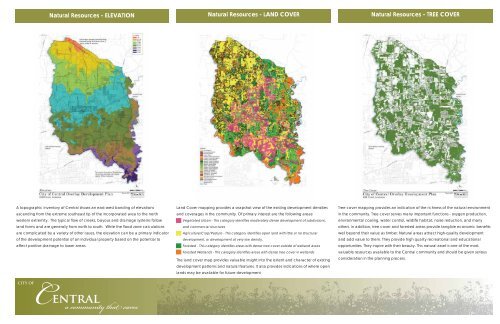
Natural Resources - ELEVATION<br />
Natural Resources - LAND COVER<br />
Natural Resources - TREE COVER<br />
A topographic inventory <strong>of</strong> <strong>Central</strong> shows an east-west banding <strong>of</strong> elevations<br />
ascending from the extreme southeast tip <strong>of</strong> the incorporated area to the north<br />
western extremity. The typical fl ow <strong>of</strong> creeks, bayous and drainage systems follow<br />
land forms and are generally from north to south. While the fl ood zone calculations<br />
are complicated by a variety <strong>of</strong> other issues, the elevation can be a primary indicator<br />
<strong>of</strong> the development potential <strong>of</strong> an individual property based on the potential to<br />
affect positive drainage to lower areas.<br />
Land Cover mapping provides a snapshot view <strong>of</strong> the existing development densities<br />
and coverages in the community. Of primary interest are the following areas:<br />
Vegetated Urban - This category identifi es moderately dense development <strong>of</strong> subdivisions,<br />
and commercial structures<br />
Agriculture/Crop/Pasture - This category identifi es open land with little or no structural<br />
development, or development at very low density.<br />
Forested - This category identifi es areas with dense tree cover outside <strong>of</strong> wetland areas<br />
Forested Wetlands - This category identifi es areas with dense tree cover in wetlands<br />
The land cover map provides valuable insight into the extent and character <strong>of</strong> existing<br />
development patterns and natural features. It also provides indications <strong>of</strong> where open<br />
lands may be available for future development<br />
Tree cover mapping provides an indication <strong>of</strong> the richness <strong>of</strong> the natural environment<br />
in the community. Tree cover serves many important functions - oxygen production,<br />
environmental cooling, water control, wildlife habitat, noise reduction, and many<br />
others. In addition, tree cover and forested areas provide tangible economic benefi ts<br />
well beyond their value as timber. Natural areas attract high-quality development<br />
and add value to them. They provide high quality recreational and educational<br />
opportunities. They inspire with their beauty. This natural asset is one <strong>of</strong> the most<br />
valuable resources available to the <strong>Central</strong> community and should be given serious<br />
consideration in the <strong>plan</strong>ning process.<br />
CITY OF<br />
<strong>Central</strong><br />
a community that cares