master plan - City of Central
master plan - City of Central
master plan - City of Central

Create successful ePaper yourself
Turn your PDF publications into a flip-book with our unique Google optimized e-Paper software.
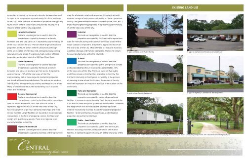
EXISTING LAND USE<br />
properties occupied by homes at a density between two and<br />
four per acre. It represents approximately 5% <strong>of</strong> the total area<br />
<strong>of</strong> the <strong>City</strong>. These medium lot residential properties are typically<br />
found within uniform subdivisions and provide housing for a<br />
majority <strong>of</strong> the <strong>Central</strong> <strong>City</strong> population.<br />
Large Lot Residential<br />
This land use designation is used to describe<br />
properties occupied by homes at a density<br />
between one and two per acre. It represents approximately 8%<br />
<strong>of</strong> the total area <strong>of</strong> the <strong>City</strong>. Most <strong>of</strong> these large lot residential<br />
properties are found within uniform subdivisions although<br />
some are located on individual lots along previously existing<br />
roadways in rural areas. A surprisingly high number <strong>of</strong> these<br />
properties are located inside the 100 Year Flood Zone.<br />
Estate Residential<br />
This land use designation is used to describe<br />
properties occupied by homes at a density<br />
between one per acre and one per fi ve acres. It represents<br />
approximately 12.0% <strong>of</strong> the total area <strong>of</strong> the <strong>City</strong>.<br />
Approximately half <strong>of</strong> these large lot residential properties<br />
are found within uniform subdivisions. The rest are located on<br />
individual lots along previously existing roadways in rural areas.<br />
Many <strong>of</strong> these have detached outbuildings such as barns,<br />
sheds and workshops.<br />
General Commercial<br />
This land use designation is used to describe<br />
properties occupied by facilities and/or operations<br />
used for indoor wholesale, retail and <strong>of</strong>fi ce activities. It<br />
represents approximately 1% <strong>of</strong> the total area <strong>of</strong> the <strong>City</strong>.<br />
Facilities vary from large retail stores to small shops and food<br />
service facilities. Larger facilities are located at major roadway<br />
intersections in the form <strong>of</strong> shopping centers. Architectural<br />
design and quality vary greatly. There is no regional retail<br />
currently located in the <strong>City</strong>.<br />
Highway Commercial<br />
This land use designation is used to describe<br />
properties occupied by facilities and/or operations<br />
CITY OF<br />
used for wholesale, retail and service activities typically with<br />
outdoor storage <strong>of</strong> equipment and products. These operations<br />
usually can generate environmental impacts (noise, dust, etc...)<br />
that affect neighboring properties. It represents approximately<br />
1% <strong>of</strong> the total area <strong>of</strong> the <strong>City</strong>.<br />
Industrial<br />
This land use designation is used to describe<br />
properties occupied by facilities and/or operations<br />
used for manufacturing and assembly activities, usually with a<br />
major outdoor component. It represents approximately 3% <strong>of</strong><br />
the total area <strong>of</strong> the <strong>City</strong>. Most <strong>of</strong> these facilities are materials<br />
assembly, storage and transfer operations. There is no known<br />
heavy manufacturing within the city limits.<br />
Schools<br />
This land use designation is used to describe<br />
properties occupied by public and private schools<br />
and associated facilities. It represents approximately .75%<br />
<strong>of</strong> the total area <strong>of</strong> the <strong>City</strong>. There are currently fi ve public<br />
and three private school facilities operating in the <strong>City</strong>. The<br />
<strong>Central</strong> Community School System is currently in the process<br />
<strong>of</strong> <strong>plan</strong>ning a new school facility near the center <strong>of</strong> the city<br />
which will represent an important addition to education on the<br />
community.<br />
Parks and Recreation<br />
This land use designation is used to describe<br />
properties occupied by park and recreational<br />
facilities. It represents approximately 3% <strong>of</strong> the total area <strong>of</strong> the<br />
<strong>City</strong>. Most <strong>of</strong> these are public parks operated by BREC. However<br />
the designation also includes several privately operated<br />
outdoor recreational facilities. It also shows several proposed<br />
facilities - Greenwell Springs, Hooper Road, and mitigation<br />
properties along the Comite River.<br />
Public - Semi Public<br />
This land use designation is used to describe<br />
properties occupied by public and semi-public<br />
facilities including churches, and government <strong>of</strong>fi ces and<br />
facilities. It represents approximately .5% <strong>of</strong> the total area <strong>of</strong> the<br />
<strong>City</strong>.<br />
A typical Public-Semi Public facility<br />
A typical General Commercial development<br />
A typical Low Density Residence<br />
A typical Highway Commercial development<br />
Both <strong>of</strong> these are Estate Residential when occupying more than one acre - undeveloped portions are classifi ed as Rural/Agricultural<br />
<strong>Central</strong><br />
a community that cares