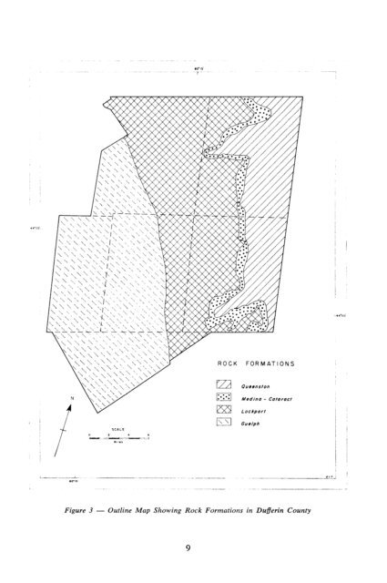
I - ---- i 00.15 OYP ! - -.-- Figure 3 - Outline Map Showing Rock Formations in Duferin County 9
probably windblown <strong>and</strong> comparable to the much more abundant “loess” of the Mississippi valley. The silt covering is thinnest near the west side of the county <strong>and</strong> is thickest (4 to 5 feet) in the area between Shelburne <strong>and</strong> Honeywood. Although the till is usually loam in texture, fairly large areas of clay loam till occur in East Garafraxa Township <strong>and</strong> some areas of clay till are found near the Escarpment northeast of Shelburne. A part of the Port Huron morainic system forms the core of the region included in most of Mulmur <strong>and</strong> Mono Townships. This region consists mainly of kame moraines which are very hilly, <strong>and</strong> stony. The moraines are a complex mixture consisting largely of s<strong>and</strong>s <strong>and</strong> gravel materials, but with clay till, coarse, stony, s<strong>and</strong>y loam till <strong>and</strong> loam till, often covered by two or three feet of silt or fine s<strong>and</strong>y loam, in association with the s<strong>and</strong> <strong>and</strong> gravel. Between the hills of the moraines there are valleys or spillways in which the soil materials are mainly gravel often covered by three or four feet of fine s<strong>and</strong>. Although isolated deposits of these materials occur throughout the county, the principal areas of such materials are north of Orangeville <strong>and</strong> in the Gr<strong>and</strong> River valley. Small areas of outwash s<strong>and</strong> occur in various sections of the county. Eskers which are gravel deposits in the form of long, narrow, winding ridges also occur in some parts of the area. Two or three good examples may be found east <strong>and</strong> north of Shelburne. L,acustrine deposits are sorted fine textured materials laid down in still or very slowly moving waters. The lacustrine deposits in Dufferin County are probably due to local ponding as they are comparatively small <strong>and</strong> occur mainly in the low areas between the hills. Swamps are common in low lying areas where the water has been impounded. In such places organic materials have accumulated. Organic deposits are scattered throughout the county, the largest of which is the Luther Marsh. TABLE 2 SURFACE DEPOSITS OCCURRING IN DUFFERIN COUNTY 1. GLACIAL TILL: Ground Moraine Generally unsorted material. Topography is characterized by a succession of low knolls <strong>and</strong> depressions. Textures are loam to clay loam - contains stones <strong>and</strong> boulders. Terminal Moraine .Often modified or resorted materials, s<strong>and</strong>y loam to loam, more stones than in ground moraine. Topography is rough to hilly. Drumlin .,,.,.,,..._.. ,,,.... .._,..,.... Elongated hill, long axis in the direction of ice advance, materials usually unsorted, loam to clay loam with stones <strong>and</strong> boulders. 2. GLACIO-FLUVIAL: Outwash Plain ._... S<strong>and</strong>y <strong>and</strong> gravelly materials, cobbly but boulder-free occurring on a nearly level plain; a few enclosed depressions <strong>and</strong> incised ravines. Kame ,. .._.... ,. . . . ..,,.... Small hill of s<strong>and</strong> <strong>and</strong> gravel - stones <strong>and</strong> boulders. may contain resorted till; some 3. LACUSTRINE . . ..,,.,..... Clays, silts <strong>and</strong> s<strong>and</strong>s laid down in glacial lakes. Topography is usually very gently sloping, although moderately steep slopes encountered in some areas. Stones are few to absent except in areas where thin lacustrial deposits are underlain with till. 4. RECENT ALLUVIAL Post-Glacial deposits of s<strong>and</strong>s, silts <strong>and</strong> clays along streams, meadows, slough <strong>and</strong> marshes. Also includes mucks <strong>and</strong> peats. Soils are immature; topography is nearly level to depressional. Stones are rare. 10