
You also want an ePaper? Increase the reach of your titles
YUMPU automatically turns print PDFs into web optimized ePapers that Google loves.
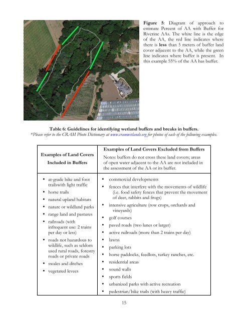
Figure 5: Diagram of approach to<br />
estimate Percent of AA with Buffer for<br />
Riverine AAs. The white line is the edge<br />
of the AA, the red line indicates where<br />
there is less than 5 meters of buffer land<br />
cover adjacent to the AA, while the green<br />
line indicates where buffer is present. In<br />
this example 55% of the AA has buffer.<br />
Table 6: Guidelines for identifying wetland buffers and breaks in buffers.<br />
*Please refer to the CRAM Photo Dictionary at www.cramwetlands.org for photos of each of the following examples.<br />
Examples of Land Covers<br />
Included in Buffers<br />
• at-grade bike and foot<br />
trailswith light traffic<br />
• horse trails<br />
• natural upland habitats<br />
• nature or wildland parks<br />
• range land and pastures<br />
• railroads (with<br />
infrequent use: 2 trains<br />
per day or less)<br />
• roads not hazardous to<br />
wildlife, such as seldom<br />
used rural roads, forestry<br />
roads or private roads<br />
• swales and ditches<br />
• vegetated levees<br />
Examples of Land Covers Excluded from Buffers<br />
Notes: buffers do not cross these land covers; areas<br />
of open water adjacent to the AA are not included in<br />
the assessment of the AA or its buffer.<br />
• commercial developments<br />
• fences that interfere with the movements of wildlife<br />
(i.e. food safety fences that prevent the movement<br />
of deer, rabbits and frogs)<br />
• intensive agriculture (row crops, orchards and<br />
vineyards)<br />
• golf courses<br />
• paved roads (two lanes or larger)<br />
• active railroads (more than 2 trains per day)<br />
• lawns<br />
• parking lots<br />
• horse paddocks, feedlots, turkey ranches, etc.<br />
• residential areas<br />
• sound walls<br />
• sports fields<br />
• urbanized parks with active recreation<br />
• pedestrian/bike trails (with heavy traffic)<br />
15