
You also want an ePaper? Increase the reach of your titles
YUMPU automatically turns print PDFs into web optimized ePapers that Google loves.
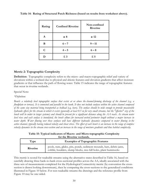
Table 14: Rating of Structural Patch Richness (based on results from worksheet above).<br />
Rating<br />
Confined Riverine<br />
Non-confined<br />
Riverine<br />
A ≥ 8 ≥ 12<br />
B 6 – 7 9 – 11<br />
C 4 – 5 6 – 8<br />
D ≤ 3 ≤ 5<br />
Metric 2: Topographic Complexity<br />
Definition: Topographic complexity refers to the micro- and macro-topographic relief and variety of<br />
elevations within a wetland due to physical and abiotic features and elevation gradients that affect moisture<br />
gradients or that influence the path of flowing water. Table 15 indicates the range of topographic features<br />
that occur in riverine wetlands.<br />
Special Note:<br />
*Definition:<br />
Bench: a relatively level topographic surface that exists at or above the channel-forming discharge of the channel (e.g. a<br />
floodplain or terrace). It is connected and parallel to the bank. It does not include surfaces within the active channel composed<br />
of the same size material being transported as bedload (e.g. bars). The surface should be wide enough to provide measurable<br />
hydraulic effects for the stream in which it exists (generally at least 0.5 m for very small streams, but the "effective" size of the<br />
bench will be wider in larger systems) and should be present for a significant distance along the AA reach. As stream water<br />
level rises and each surface is inundated, the bench allows for increased wetted perimeter length without a major increase in<br />
water depth. Water flowing over these surfaces will have different hydraulic dynamics compared to water flowing in the<br />
active channel, typically having reduced velocity and shear stress. The effect of each bench is an increase in the range of complex<br />
velocity dynamics in the stream cross-section and an increase in the range of moisture gradients and thus habitat complexity.<br />
Table 15: Typical indicators of Macro- and Micro-topographic Complexity<br />
for the Riverine wetlands.<br />
Type<br />
Examples of Topographic Features<br />
Riverine<br />
pools, runs, glides, pits, ponds, sediment mounds, bars, debris jams,<br />
cobble, boulders, slump blocks, tree-fall holes, plant hummocks<br />
This metric is scored for wadeable streams using the alternative states described in Table 16, based on<br />
carefully drawing three bank-to-bank cross-sectional profiles across the AA, ideally associated with the<br />
three sets of measurements completed for the Hydrological Connectivity metric (by convention the crosssection<br />
is drawn looking downstream), then by comparing the cross-sections to the generalized conditions<br />
illustrated in Figure 10 below. For non-wadeable streams the drawings and the reference profile from<br />
Figure 10 may be one-sided.<br />
30