
You also want an ePaper? Increase the reach of your titles
YUMPU automatically turns print PDFs into web optimized ePapers that Google loves.
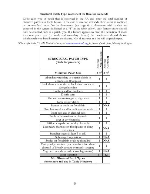
Structural Patch Type Worksheet for Riverine wetlands<br />
Circle each type of patch that is observed in the AA and enter the total number of<br />
observed patches in Table below. In the case of riverine wetlands, their status as confined<br />
or non-confined must first be determined (see page 6) to determine with patches are<br />
expected in the system (indicated by a “1” in the table below). Any feature onsite should<br />
only be counted once as a patch type. If a feature appears to meet the definition of more<br />
than one patch type (i.e. swale and secondary channel) the practitioner should choose<br />
which patch type best illustrates the feature. Not all features at a site will be patch types.<br />
*Please refer to the CRAM Photo Dictionary at www.cramwetlands.org for photos of each of the following patch types.<br />
STRUCTURAL PATCH TYPE<br />
(circle for presence)<br />
Riverine<br />
(Non-confined)<br />
Riverine<br />
(Confined)<br />
Minimum Patch Size 3 m 2 3 m 2<br />
Abundant wrackline or organic debris in<br />
channel, on floodplain<br />
1 1<br />
Bank slumps or undercut banks in channels or<br />
along shoreline<br />
1 1<br />
Cobbles and/or Boulders 1 1<br />
Debris jams 1 1<br />
Filamentous macroalgae or algal mats 1 1<br />
Large woody debris 1 1<br />
Pannes or pools on floodplain 1 N/A<br />
Plant hummocks and/or sediment mounds 1 1<br />
Point bars and in-channel bars 1 1<br />
Pools or depressions in channels<br />
(wet or dry channels)<br />
1 1<br />
Riffles or rapids (wet or dry channels) 1 1<br />
Secondary channels on floodplains or along<br />
shorelines<br />
1 N/A<br />
Standing snags (at least 3 m tall) 1 1<br />
Submerged vegetation 1 N/A<br />
Swales on floodplain or along shoreline 1 N/A<br />
Variegated, convoluted, or crenulated foreshore<br />
(instead of broadly arcuate or mostly straight)<br />
1 1<br />
Vegetated islands (mostly above high-water) 1 N/A<br />
Total Possible 17 12<br />
No. Observed Patch Types<br />
(enter here and use in Table 14 below)<br />
29