KI Traveller's Levy Economic Impact Assessment - Kangaroo Island ...
KI Traveller's Levy Economic Impact Assessment - Kangaroo Island ...
KI Traveller's Levy Economic Impact Assessment - Kangaroo Island ...

Create successful ePaper yourself
Turn your PDF publications into a flip-book with our unique Google optimized e-Paper software.
Commercial-in-Confidence<br />
<strong>KI</strong> Traveller’s <strong>Levy</strong><br />
<strong>Impact</strong> <strong>Assessment</strong><br />
1.1 <strong>KI</strong> REGIONAL PROFILE<br />
1.1.1 GEOGRAPHIC CHARACTERISTICS<br />
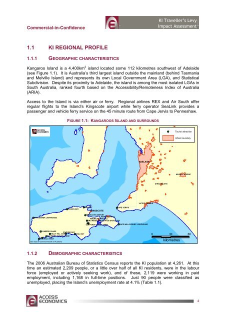
<strong>Kangaroo</strong> <strong>Island</strong> is a 4,400km 2 island located some 112 kilometres southwest of Adelaide<br />
(see Figure 1.1). It is Australia’s third largest island outside the mainland (behind Tasmania<br />
and Melville <strong>Island</strong>) and represents its own Local Government Area (LGA), and Statistical<br />
Subdivision. Despite its proximity to Adelaide, the island is among the most isolated LGAs in<br />
South Australia, ranked fourth based on the Accessibility/Remoteness Index of Australia<br />
(ARIA).<br />
Access to the <strong>Island</strong> is via either air or ferry. Regional airlines REX and Air South offer<br />
regular flights to the <strong>Island</strong>’s Kingscote airport while ferry operator SeaLink provides a<br />
passenger and vehicle ferry service on the 45 minute route from Cape Jervis to Penneshaw.<br />
FIGURE 1.1: KANGAROOS ISLAND AND SURROUNDS<br />
Tourist attraction<br />
Urban boundary<br />
ADELAIDE<br />
MURRAY BRIDGE<br />
STRATHALBYN<br />
VICTOR HARBOR<br />
STOKES BAY<br />
EMU BAY<br />
<strong>KI</strong>NGSCOTE<br />
CAPE JERVIS<br />
CAPE BORDA LIGHTHOUSE<br />
<strong>KI</strong>NGSCOTE AIRPORT<br />
PENNESHAW (L)<br />
AMERICAN RIVER (L)<br />
EMU RIDGE EUCALYPTUS DISTILLERY<br />
CLIFFORDS HONEY FARM<br />
CAPE WILLOUGHBY LIGHTHOUSE<br />
FLINDERS CHASE<br />
VIVONNE BAY<br />
KELLY HILL CAVES SEAL BAY<br />
SOUTHERN OCEAN LODGE<br />
ADMIRALS ARCH<br />
GIS data © Commonwealth of Australia<br />
0 30 60<br />
kilometres<br />
1.1.2 DEMOGRAPHIC CHARACTERISTICS<br />
The 2006 Australian Bureau of Statistics Census reports the <strong>KI</strong> population at 4,261. At this<br />
time an estimated 2,209 people, or a little over half of all <strong>KI</strong> residents, were in the labour<br />
force (employed or actively seeking work), and of these, 2,119 were working in paid<br />
employment, including 1,168 in full-time positions. Just 90 people were classified as<br />
unemployed, placing the <strong>Island</strong>’s unemployment rate at 4.1% (Table 1.1).<br />
4