Fremantle Port Inner Harbour and Channel ... - Fremantle Ports
Fremantle Port Inner Harbour and Channel ... - Fremantle Ports
Fremantle Port Inner Harbour and Channel ... - Fremantle Ports
You also want an ePaper? Increase the reach of your titles
YUMPU automatically turns print PDFs into web optimized ePapers that Google loves.
will be dynamic. One site will incorporate taking sample water from the weir box itself - this<br />
will only occur if there is safe access to the site. Three samples will occur along the plume<br />
trajectory at distances of 10 m, 200 m <strong>and</strong> 500 m beyond the silt curtain. The fifth <strong>and</strong> sixth<br />
sites will be reference sites <strong>and</strong> located at the Cottesloe Reef Fish Habitat Protection Area<br />
(Figure 3.1).<br />
3.3. <strong>Inner</strong> <strong>Harbour</strong> Dredge Plume<br />
Samples will be taken at four monitoring sites along a plume transect at increasing distance<br />
from the dredge head while it is operational within the <strong>Inner</strong> <strong>Harbour</strong>, with an example<br />
shown in Figure 3.1 <strong>and</strong> Figure 3.2. The transect will follow the approximate trajectory of the<br />
plume <strong>and</strong> therefore will be dynamic. Four samples will occur along the plume trajectory at<br />
distances of 10 m, 50 m, 100 m <strong>and</strong> 500 m from the dredge head. An additional (fifth) ‘at<br />
source’ water sample will be taken from the dredge ‘tailings’ slurry, prior to deposition within<br />
the reclamation area.<br />
3.4. Offshore Dredge <strong>and</strong> Disposal Plume<br />
Water samples will be taken at four monitoring sites along a plume transect at increasing<br />
distance from either (i) the dredge head while it is operational within Deep Water <strong>Channel</strong> or<br />
(ii) the local site of offshore disposal, with an example shown in Figure 3.1. The transect will<br />
follow the approximate trajectory of the plume <strong>and</strong> therefore will be dynamic. Four samples<br />
will occur along the plume trajectory at distances of 10 m, 50 m, 100 m <strong>and</strong> 500 m from<br />
either the dredge head or local site of offshore disposal.<br />
3.5. Recreation <strong>and</strong> Aesthetic Water Quality<br />
As depicted in Figure 3.1, six monitoring locations have been located in the vicinity of<br />
proximal public beaches, for contingency water quality sampling to determine potential<br />
impacts on recreational <strong>and</strong> aesthetic values:<br />
• <strong>Port</strong> Beach (‘S<strong>and</strong>tracks’ surf break);<br />
• <strong>Fremantle</strong> Surf Life Saving Club;<br />
• Cottesloe Beach;<br />
• Bather’s Beach;<br />
• South Beach; <strong>and</strong>,<br />
• Preston Point Beach (in the Lower Swan River).<br />
3.6. <strong>Inner</strong> <strong>Harbour</strong> <strong>and</strong> Rous Head Water, Sentinel Mussel <strong>and</strong><br />
Sediment Quality<br />
A total of six locations surrounding the <strong>Inner</strong> <strong>Harbour</strong> <strong>and</strong> Rous Head will be utilised for water<br />
quality monitoring (3 locations), sentinel mussel quality monitoring (all 6 locations) <strong>and</strong><br />
sediment quality monitoring (5 locations), as depicted in Figure 3.1, Figure 3.2 <strong>and</strong> Table 3.2.<br />
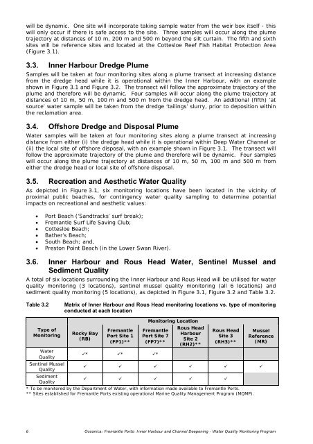
Table 3.2<br />
Matrix of <strong>Inner</strong> <strong>Harbour</strong> <strong>and</strong> Rous Head monitoring locations vs. type of monitoring<br />
conducted at each location<br />
Type of<br />
Monitoring<br />
Rocky Bay<br />
(RB)<br />
<strong>Fremantle</strong><br />
<strong>Port</strong> Site 1<br />
(FP1)**<br />
Monitoring Location<br />
<strong>Fremantle</strong><br />
<strong>Port</strong> Site 7<br />
(FP7)**<br />
Rous Head<br />
<strong>Harbour</strong><br />
Site 2<br />
(RH2)**<br />
Rous Head<br />
Site 3<br />
(RH3)**<br />
Mussel<br />
Reference<br />
(MR)<br />
Water<br />
Quality<br />
* * *<br />
Sentinel Mussel<br />
Quality<br />
<br />
Sediment<br />
Quality<br />
<br />
* To be monitored by the Department of Water, with information made available to <strong>Fremantle</strong> <strong>Port</strong>s.<br />
** Sites established for <strong>Fremantle</strong> <strong>Port</strong>s existing operational Marine Quality Management Program (MQMP).<br />
6 Oceanica: <strong>Fremantle</strong> <strong>Port</strong>s: <strong>Inner</strong> <strong>Harbour</strong> <strong>and</strong> <strong>Channel</strong> Deepening - Water Quality Monitoring Program


