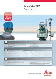
Leica Viva TS11 Datasheet
Leica Viva TS11 Datasheet
Leica Viva TS11 Datasheet

You also want an ePaper? Increase the reach of your titles
YUMPU automatically turns print PDFs into web optimized ePapers that Google loves.
<strong>Leica</strong> <strong>Viva</strong> <strong>TS11</strong><br />
<strong>Datasheet</strong><br />
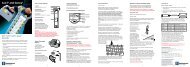
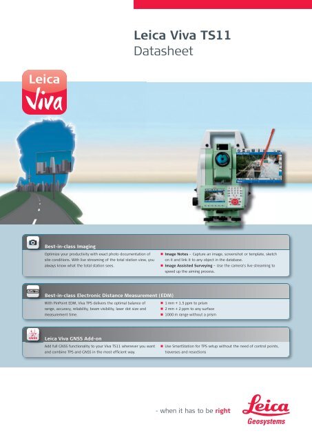
Best-in-class Imaging<br />
Optimize your productivity with exact photo documentation of<br />
site conditions. With live streaming of the total station view, you<br />
always know what the total station sees.<br />
• Image Notes – Capture an image, screenshot or template, sketch<br />
on it and link it to any object in the database.<br />
• Image Assisted Surveying – Use the camera’s live streaming to<br />
speed up the aiming process.<br />
Best-in-class Electronic Distance Measurement (EDM)<br />
With PinPoint EDM, <strong>Viva</strong> TPS delivers the optimal balance of<br />
range, accuracy, reliability, beam visibility, laser dot size and<br />
measurement time.<br />
• 1 mm + 1.5 ppm to prism<br />
• 2 mm + 2 ppm to any surface<br />
• 1000 m range without a prism<br />
<strong>Leica</strong> <strong>Viva</strong> GNSS Add-on<br />
Add full GNSS functionality to your <strong>Viva</strong> <strong>TS11</strong> whenever you want<br />
and combine TPS and GNSS in the most efficient way.<br />
• Use SmartStation for TPS setup without the need of control points,<br />
traverses and resections
Technical Specifications <strong>TS11</strong><br />
<strong>Leica</strong> <strong>Viva</strong> <strong>TS11</strong> <strong>TS11</strong> <strong>TS11</strong> I<br />
Angle measurement • •<br />
Distance measurement to prism • •<br />
Distance measurement to any surface (reflectorless) • •<br />
Wide-Angle Camera — •<br />
RS232, USB and SD card interface • •<br />
Bluetooth • •<br />
Internal Flash Memory (1GB) • •<br />
Guide Light (EGL) •<br />
Arctic Option <br />
SmartStation GS15 GNSS receiver <br />
SmartStation GS12 GNSS receiver <br />
CS10/CS15 (Radio) field controller <br />
• = Standard<br />
= Optional<br />
— = Not available<br />
Angular Measurement Accuracy Hz, V 1 1’’ (0.3 mgon), 2’’ (0.6 mgon), 3’’ (1 mgon), 5’’ (1.5 mgon)<br />
Display resolution<br />
0.1’’ (0.1 mgon)<br />
Method<br />
Compensation<br />
absolute, continuous, diametrical<br />
Quadruple axis compensation<br />
Compensator setting accuracy<br />
0.5’’ (0.2 mgon), 0.5’’ (0.2 mgon), 1.0’’ (0.3 mgon), 1.5’’ (0.5 mgon)<br />
Distance Measurement<br />
Distance Measurement (Prism)<br />
Range 2<br />
Round prism (GPR1)<br />
3500 m (12000 ft)<br />
3 Round prisms (GPR1) 5400 m (17700 ft)<br />
360° prism (GRZ4, GRZ122) 2000 m (7000 ft)<br />
360° mini prism (GRZ101) 1000 m (3300 ft)<br />
Mini prism (GMP101)<br />
2000 m (7000 ft)<br />
Reflective tape (60 mm x 60 mm)<br />
250 m (800 ft)<br />
Accuracy 3,4 / Measurement Time<br />
Standard<br />
1 mm + 1.5 ppm / typ. 2.4 s<br />
Fast<br />
3 mm + 1.5 ppm / typ. 0.8 s<br />
Continuous<br />
3 mm + 1.5 ppm / typ. 10000 m (>32800 ft)<br />
Accuracy 3,6 / Measurement Time<br />
Long-range<br />
5 mm + 2 ppm / typ. 2.5 s<br />
General<br />
Display resolution<br />
0.1 mm<br />
Shortest measurable distance<br />
1.5 m<br />
Method<br />
System analyzer based on phase shift measurement (coaxial, visible red laser)<br />
Laser dot size (Non-Prism)<br />
At 30 m: 7 mm x 10 mm, at 50 m: 8 mm x 20 mm<br />
General<br />
Operating system & Processor<br />
Operating System Windows CE 6.0<br />
Processor<br />
Freescale i.MX31 533 MHz ARM Core<br />
Telescope<br />
Magnification<br />
30 x<br />
Free objective aperture<br />
40 mm<br />
Field of view<br />
1° 30’ (1.66 gon) / 2.7 m at 100 m<br />
Focusing range<br />
1.7 m to infinity<br />
Keyboard and Display<br />
Display<br />
640 x 480 pixel (VGA) color TFT with LED backlight and touch screen<br />
Keyboard<br />
36 keys (12 function keys, 12 alphanumeric keys), illumination<br />
Position<br />
face I standard / face II optional<br />
Memory, Ports & Communication<br />
Internal memory / Memory devices<br />
1 GB (nonvolatile NAND Flash) / SD card, USB stick<br />
Interfaces<br />
RS232, Bluetooth ® Wireless-Technology, USB mini AB OTG<br />
Operation<br />
Sensitivity of Circular level<br />
6’ / 2 mm<br />
Centering accuracy of Laser plummet<br />
1.5 mm at 1.5 m<br />
Number of drives<br />
1 horizontal / 1 vertical<br />
Power Management<br />
Internal Battery<br />
Lithium Ion<br />
Operating Time<br />
5 – 8 h (GEB221)<br />
Voltage / Capacity<br />
7.4 V / 4.4 Ah<br />
Weight and Dimensions<br />
Weight of Total Station / Battery GEB221 / Tribrach GEB121 4.8 – 5.1 kg / 0.2 kg / 0.8 kg<br />
Height / Width / Length<br />
345 mm / 226 mm / 203 mm<br />
Environmental specifications<br />
Working / Storage temperature range<br />
-20° C to +50° C / -40° C to +70° C<br />
Dust / water (IEC 60529) / Humidity<br />
IP55 / 95%, non-condensing<br />
Guide Light (EGL) Working Range 5 – 150 m<br />
Positioning accuracy<br />
5 cm at 100 m
<strong>Leica</strong> <strong>Viva</strong> Imaging<br />
Wide-angle Camera<br />
Sensor 5 Mpixel CMOS sensor<br />
Focal Length<br />
21 mm<br />
Field of view<br />
15.5° x 11.7° (19.4° diagonal)<br />
Frame rate<br />
20 frames per second<br />
Focus<br />
2 m (6.5 feet) to infinity<br />
Image storage JPEG up to 5 Mpixel (2560 x 1920)<br />
Zoom 3-step (1x, 2x, 4x)<br />
Whitebalance<br />
User configurable<br />
Brightness<br />
User configurable<br />
<strong>Leica</strong> <strong>Viva</strong> SmartStation<br />
Add-on GS12 / GS15 Position accuracy 9,10 Horizontal: 10 mm + 1 ppm, Vertical: 20 mm + 1 ppm<br />
RTK Initialization<br />
Reliability / Time of initialization<br />
>99.99% / Typically 8 s, with 5 or more satellites on L1 and L2<br />
Range<br />
Up to 50 km, assuming reliable data-link is available<br />
RTK Data formats for data reception<br />
<strong>Leica</strong> proprietary formats (<strong>Leica</strong>, <strong>Leica</strong> 4G), GPS and GNSS real-time data<br />
formats, CMR, CMR+, RTCM v2.1 / 2.2 / 2.3 / 3.x<br />
GNSS Antenna<br />
Number of channels GS15: 120<br />
GS12: 120<br />
Dimensions (diameter x height)<br />
GS15: 196 mm x 198 mm<br />
GS12: 186 mm x 89 mm<br />
Weight<br />
GS15: 1.34 kg<br />
GS12: 1.05 kg<br />
1<br />
Standard deviation ISO 17123-3<br />
2<br />
Overcast, no haze, visibility about 40 km; no heat shimmer<br />
3<br />
Standard deviation ISO 17123-4<br />
4<br />
To Round Prism GPR1<br />
5<br />
Fast Mode<br />
6<br />
Object in shade, sky overcast, Kodak Grey Card (90% reflective)<br />
7<br />
Distance >500 m 4 mm + 2 ppm<br />
8<br />
Target perfectly aligned to the instrument<br />
9<br />
Measurement precision, accuracy and reliability are dependent upon various factors including number of satellites, geometry,<br />
obstructions, observation time, ephemeris accuracy, ionospheric conditions, multipath etc. Figures quoted assume normal to<br />
favorable conditions. Times can also not be quoted exactly. Times required are dependent upon various factors including number<br />
of satellites, geometry, ionospheric conditions, multipath etc. The following accuracies, given as root mean square,<br />
are based on real-time measurements.<br />
10<br />
When used within reference station networks the position accuracy is in accordance with the accuracy specifications provided by<br />
the reference station network.
Whether you want to stake-out an object on a construction site or you<br />
need accurate measurements of a tunnel or a bridge; whether you<br />
want to determine the area of a parcel of land or need the position of<br />
a power pole or to capture objects for as-built maps – you need<br />
reliable and precise data.<br />
<strong>Leica</strong> <strong>Viva</strong> combines a wide range of innovative products designed to<br />
meet the daily challenges for all positioning tasks. The simple yet<br />
powerful and versatile <strong>Leica</strong> <strong>Viva</strong> hardware and software innovations<br />
are redefining state-of-the-art technology to deliver maximum performance<br />
and productivity. <strong>Leica</strong> <strong>Viva</strong> gives you the inspiration to make<br />
your ambitious visions come true.<br />
When it has to be right.<br />
Illustrations, descriptions and technical data are not binding. All rights reserved.<br />
Printed in Switzerland – Copyright <strong>Leica</strong> Geosystems AG, Heerbrugg, Switzerland, 2010.<br />
781697en – IX.10 – RDV<br />
Total Quality Management –<br />
our commitment to total<br />
customer satisfaction.<br />
Distance meter (Prism):<br />
Laser class 1 in accordance<br />
with IEC 60825-1 resp. EN<br />
60825-1<br />
Laser plummet:<br />
Laser class 2 in accordance<br />
with IEC 60825-1 resp. EN<br />
60825-1<br />
<strong>Leica</strong> <strong>Viva</strong><br />
Overview brochure<br />
<strong>Leica</strong> <strong>Viva</strong> GNSS<br />
Product brochure<br />
<strong>Leica</strong> SmartWorx<br />
<strong>Viva</strong><br />
Product brochure<br />
<strong>Leica</strong> <strong>Viva</strong> LGO<br />
Product brochure<br />
<strong>Leica</strong> Zeno<br />
Product brochure<br />
Distance meter (Non-Prism):<br />
Laser class 3R in accordance<br />
with IEC 60825-1 resp. EN<br />
60825-1<br />
The Bluetooth ® word mark and<br />
logos are owned by Bluetooth<br />
SIG, Inc. and any use of such<br />
marks by <strong>Leica</strong> Geosystems AG is<br />
under license. Other trademarks<br />
and trade names are those of<br />
their respective owners.<br />
<strong>Leica</strong> Geosystems AG<br />
Heerbrugg, Switzerland<br />
www.leica-geosystems.com