Uniform Mitigation Assessment Method TRAINING MANUAL
Uniform Mitigation Assessment Method TRAINING MANUAL
Uniform Mitigation Assessment Method TRAINING MANUAL

Create successful ePaper yourself
Turn your PDF publications into a flip-book with our unique Google optimized e-Paper software.
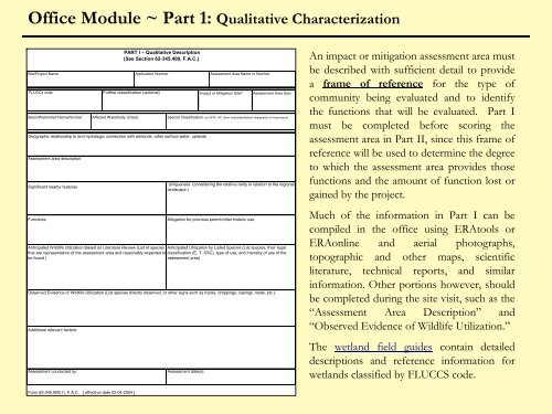
Office Module ~ Part 1: Qualitative Characterization<br />
Site/Project Name Application Number <strong>Assessment</strong> Area Name or Number<br />
FLUCCs code<br />
Basin/Watershed Name/Number<br />
Additional relevant factors:<br />
<strong>Assessment</strong> conducted by:<br />
Affected Waterbody (Class)<br />
PART I – Qualitative Description<br />
(See Section 62-345.400, F.A.C.)<br />
Further classification (optional)<br />
Geographic relationship to and hydrologic connection with wetlands, other surface water, uplands<br />
<strong>Assessment</strong> area description<br />
Significant nearby features<br />
Functions<br />
<strong>Assessment</strong> date(s):<br />
Impact or <strong>Mitigation</strong> Site<br />
<strong>Assessment</strong> Area Size<br />
Special Classification (i.e.OFW, AP, other local/state/federal designation of importance)<br />
Uniqueness (considering the relative rarity in relation to the regional<br />
landscape.)<br />
<strong>Mitigation</strong> for previous permit/other historic use<br />
Anticipated Wildlife Utilization Based on Literature Review (List of species Anticipated Utilization by Listed Species (List species, their legal<br />
that are representative of the assessment area and reasonably expected to classification (E, T, SSC), type of use, and intensity of use of the<br />
be found )<br />
assessment area)<br />
Observed Evidence of Wildlife Utilization (List species directly observed, or other signs such as tracks, droppings, casings, nests, etc.):<br />
An impact or mitigation assessment area must<br />
be described with sufficient detail to provide<br />
a frame of reference for the type of<br />
community being evaluated and to identify<br />
the functions that will be evaluated. Part I<br />
must be completed before scoring the<br />
assessment area in Part II, since this frame of<br />
reference will be used to determine the degree<br />
to which the assessment area provides those<br />
functions and the amount of function lost or<br />
gained by the project.<br />
Much of the information in Part I can be<br />
compiled in the office using ERAtools or<br />
ERAonline and aerial photographs,<br />
topographic and other maps, scientific<br />
literature, technical reports, and similar<br />
information. Other portions however, should<br />
be completed during the site visit, such as the<br />
“<strong>Assessment</strong> Area Description” and<br />
“Observed Evidence of Wildlife Utilization.”<br />
The wetland field guides contain detailed<br />
descriptions and reference information for<br />
wetlands classified by FLUCCS code.<br />
Form 62-345.900(1), F.A.C. [ effective date 02-04-2004 ]