ISIS 2D Quick Start Guide - Halcrow
ISIS 2D Quick Start Guide - Halcrow
ISIS 2D Quick Start Guide - Halcrow

You also want an ePaper? Increase the reach of your titles
YUMPU automatically turns print PDFs into web optimized ePapers that Google loves.
<strong>ISIS</strong> <strong>2D</strong> <strong>Quick</strong> <strong>Start</strong> <strong>Guide</strong><br />
How to Run an <strong>ISIS</strong> <strong>2D</strong> 1D - <strong>2D</strong> Linked Model<br />
This Chapter illustrates an example of running an existing linked <strong>ISIS</strong> 1D and <strong>2D</strong> model using the <strong>ISIS</strong><br />
<strong>2D</strong> Interface Tool. <strong>ISIS</strong> 1D-<strong>2D</strong> linked models combine the advantages of 1D modelling in the channel<br />
and <strong>2D</strong> floodplain modelling. In a linked model, the <strong>2D</strong> model will represent complex flow paths and<br />
1D river model will represent channel conveyance and the hydraulic structures in a river. Being able to<br />
link models, you can now reuse your 1D channel models and let <strong>ISIS</strong> 1D do what it is best at<br />
(modelling of channel flow and flow through various structures) and let <strong>ISIS</strong> <strong>2D</strong> show its strength at<br />
representing out of bank flows on the floodplain.<br />
Running an existing <strong>ISIS</strong> 1D-<strong>2D</strong> model using the <strong>ISIS</strong> <strong>2D</strong> Interface Tool<br />
Basic information about the files needed for the <strong>ISIS</strong> <strong>2D</strong> simulation<br />
As mentioned in Chapter 1 "<strong>Start</strong>ing <strong>ISIS</strong> <strong>2D</strong> and Basic Concepts", <strong>ISIS</strong> <strong>2D</strong> simulation requires several<br />
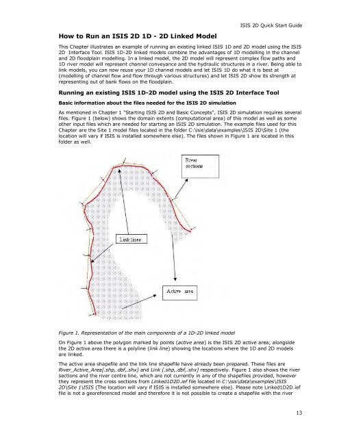
files. Figure 1 (below) shows the domain extents (computational area) of this model as well as some<br />
other input files which are needed for starting an <strong>ISIS</strong> <strong>2D</strong> simulation. The example files used for this<br />
Chapter are the Site 1 model files located in the folder C:\isis\data\examples\<strong>ISIS</strong> <strong>2D</strong>\Site 1 (the<br />
location will vary if <strong>ISIS</strong> is installed somewhere else). The files shown in Figure 1 are located in this<br />
folder as well.<br />
Figure 1. Representation of the main components of a 1D-<strong>2D</strong> linked model<br />
On Figure 1 above the polygon marked by points (active area) is the <strong>ISIS</strong> <strong>2D</strong> active area; alongside<br />
the <strong>2D</strong> active area there is a polyline (link line) showing the locations where the 1D and <strong>2D</strong> models<br />
are linked.<br />
The active area shapefile and the link line shapefile have already been prepared. These files are<br />
River_Active_Area[.shp,.dbf,.shx] and Link [.shp,.dbf,.shx] respectively. Figure 1 also shows the river<br />
sections and the river centre line, which are not currently in any of the shapefiles provided, however<br />
they represent the cross sections from Linked1D<strong>2D</strong>.ief file located in C:\isis\data\examples\<strong>ISIS</strong><br />
<strong>2D</strong>\Site 1\<strong>ISIS</strong> (The location will vary if <strong>ISIS</strong> is installed somewhere else). Please note Linked1D<strong>2D</strong>.ief<br />
file is not a georeferenced model and therefore it is not possible to create a shapefile with the river<br />
13