2010 Sustainable Streets Index - NYC.gov
2010 Sustainable Streets Index - NYC.gov
2010 Sustainable Streets Index - NYC.gov

You also want an ePaper? Increase the reach of your titles
YUMPU automatically turns print PDFs into web optimized ePapers that Google loves.
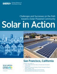
Purpose<br />
• Improve pedestrian and motorist safety<br />
• Simplify complex intersections<br />
• Enhance streetscape<br />
Outreach<br />
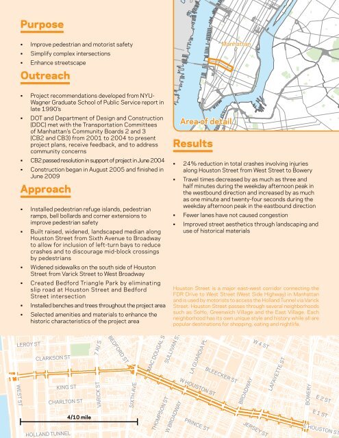
Manhattan<br />
• Project recommendations developed from NYU-<br />
Wagner Graduate School of Public Service report in<br />
late 1990’s<br />
• DOT and Department of Design and Construction<br />
(DDC) met with the Transportation Committees<br />
of Manhattan’s Community Boards 2 and 3<br />
(CB2 and CB3) from 2001 to 2004 to present<br />
project plans, receive feedback, and to address<br />
community concerns<br />
• CB2 passed resolution in support of project in June 2004<br />
• Construction began in August 2005 and finished in<br />
June 2009<br />
Approach<br />
• Installed pedestrian refuge islands, pedestrian<br />
ramps, bell bollards and corner extensions to<br />
improve pedestrian safety<br />
• Built raised, widened, landscaped median along<br />
Houston Street from Sixth Avenue to Broadway<br />
to allow for inclusion of left-turn bays to reduce<br />
crashes and to discourage mid-block crossings<br />
by pedestrians<br />
• Widened sidewalks on the south side of Houston<br />
Street from Varick Street to West Broadway<br />
• Created Bedford Triangle Park by eliminating<br />
slip road at Houston Street and Bedford<br />
Street intersection<br />
• Installed benches and trees throughout the project area<br />
• Selected amenities and materials to enhance the<br />
historic characteristics of the project area<br />
BETHUNE ST<br />
WASHINGTON ST<br />
BARROW ST<br />
MORTON ST<br />
BANK ST<br />
CHRISTOPHER ST<br />
WEST ST<br />
LEROY ST<br />
8 AV<br />
CLARKSON ST<br />
HUDSON ST<br />
KING ST<br />
HOLLAND TUNNEL<br />
BANK ST<br />
PERRY ST<br />
7 AV S<br />
W 4 ST<br />
CHRISTOPHER ST<br />
CHARLTON ST<br />
4/10 mile<br />
GROVE ST<br />
VARICK ST<br />
CHARLES ST<br />
BEDFORD ST<br />
SIXTH AVE<br />
GREENWICH AV<br />
WAVERLY PL<br />
W WASHINGTON PL<br />
JONES ST<br />
CORNELIA ST<br />
MINETTA LA<br />
MAC DOUGAL ST<br />
THOMPSON ST<br />
W 3 ST<br />
Results<br />
• 24% reduction in total crashes involving injuries<br />
along Houston Street from West Street to Bowery<br />
• Travel times decreased by as much as three and<br />
half minutes during the weekday afternoon peak in<br />
the westbound direction and increased by as much<br />
as one minute and twenty-four seconds during the<br />
weekday afternoon peak in the eastbound direction<br />
• Fewer lanes have not caused congestion<br />
• Improved street aesthetics through landscaping and<br />
use of historical materials<br />
W 11 ST<br />
W 10 ST<br />
5 AV<br />
Houston Street is a major east-west corridor connecting the<br />
FDR Drive to West Street (West Side Highway) in Manhattan<br />
and is used by motorists to access the Holland Tunnel via Varick<br />
Street. Houston Street passes through several neighborhoods<br />
such as SoHo, Greenwich Village and the East Village. Each<br />
neighborhood has its own unique style and history while all are<br />
popular destinations for shopping, eating and nightlife.<br />
SULLIVAN ST<br />
W BROADWAY<br />
Area of detail<br />
W 9 ST<br />
W 8 ST<br />
W HOUSTON ST<br />
PRINCE ST<br />
W 12 ST<br />
WASHINGTON SQ N<br />
WASHINGTON SQ S<br />
LA GUARDIA PL<br />
WASHINGTON ME<br />
BLEECKER ST<br />
BROADWAY<br />
E 11 ST<br />
E 9 ST<br />
E 8 ST<br />
WASHINGTON PL<br />
GREENE ST<br />
W 4 ST<br />
JERSEY ST<br />
UNIVERSITY PL<br />
LAFAYETTE ST<br />
E 13 ST<br />
E 12 ST<br />
E 10 ST<br />
ASTOR PL<br />
BOWERY<br />
4 AV<br />
31<br />
E 14 ST<br />
E 2 ST<br />
E 1 ST<br />
E 15<br />
E 11 ST<br />
3 A<br />
WANAMAKER PL E 9 S<br />
E 7 ST<br />
E HOUSTON ST