

Conservation Area Appraisal for Upton Grey - Basingstoke and ...
Conservation Area Appraisal for Upton Grey - Basingstoke and ...
Conservation Area Appraisal for Upton Grey - Basingstoke and ...

You also want an ePaper? Increase the reach of your titles
YUMPU automatically turns print PDFs into web optimized ePapers that Google loves.
<strong>Conservation</strong> <strong>Area</strong> <strong>Appraisal</strong><br />
<strong>Conservation</strong> <strong>Area</strong> <strong>Appraisal</strong><br />
<strong>Upton</strong> <strong>Grey</strong><br />
…making a difference<br />
<strong>Upton</strong> <strong>Grey</strong>
<strong>Conservation</strong> <strong>Area</strong> <strong>Appraisal</strong><br />
Introduction<br />
The <strong>Upton</strong> <strong>Grey</strong> <strong>Conservation</strong> <strong>Area</strong> was first designated in 1973 by<br />
<strong>Basingstoke</strong> <strong>and</strong> Deane Borough Council in recognition of the special<br />
architectural <strong>and</strong> historic interest of the village. It was subsequently<br />
extended in 1989.<br />
Having designated the <strong>Conservation</strong> <strong>Area</strong>, the Local Authority has a<br />
statutory duty to ensure that those elements that <strong>for</strong>m its particular<br />
character or appearance should be preserved or enhanced, especially<br />
when considering planning applications.<br />
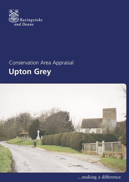
St Mary’s Church<br />
It is there<strong>for</strong>e necessary to define <strong>and</strong> analyse those qualities or elements<br />
that contribute to, or detract from, the special interest of the area <strong>and</strong><br />
to assess how they combine to justify its designation as a <strong>Conservation</strong><br />
<strong>Area</strong>. Such factors can include:<br />
• its historic development;<br />
• the contribution of individual or groups of buildings to the<br />
streetscene <strong>and</strong> the spaces that surround them; <strong>and</strong><br />
• the relationship of the built environment with the l<strong>and</strong>scape.<br />
The Old Schoolhouse <strong>and</strong> Willow Cottage<br />
They can also include the less tangible senses <strong>and</strong> experiences such<br />
as noise or smells, which can play a key part in <strong>for</strong>ming the distinctive<br />
character of an area.<br />
The <strong>Appraisal</strong> takes the <strong>for</strong>m of written text <strong>and</strong> an <strong>Appraisal</strong> plan. In<br />
both respects every ef<strong>for</strong>t has been made to include or analyse those<br />
elements key to the special character of the area. Where buildings,<br />
structures or features have not been specifically highlighted it does<br />
not necessarily follow that they are of no visual or historic value to the<br />
<strong>Conservation</strong> <strong>Area</strong>. The document is intended to be an overall framework<br />
<strong>and</strong> guide within which decisions can be made on a site-specific basis.<br />
This <strong>Appraisal</strong> of the <strong>Upton</strong> <strong>Grey</strong> <strong>Conservation</strong> <strong>Area</strong> follows its review in<br />
2003 by <strong>Basingstoke</strong> <strong>and</strong> Deane Borough Council <strong>and</strong> explains what its<br />
designation means <strong>for</strong> those who live <strong>and</strong> work in the area.<br />
This document was adopted as Supplementary Planning Guidance by the<br />
Borough of <strong>Basingstoke</strong> <strong>and</strong> Deane on 17 July 2003 <strong>and</strong> complements<br />
the policies of the Borough Local Plan (review).<br />
It has been subject to consultation with Councillors, the Parish Council<br />
<strong>and</strong> local amenity groups. A full list of consultees, copies of their<br />
responses, <strong>and</strong> details of the Council’s consideration of the issues<br />
raised during the consultation period are available <strong>for</strong> inspection, by<br />
appointment, at the Civic Offices, during normal office hours.<br />
2<br />
<strong>Upton</strong> <strong>Grey</strong>
<strong>Conservation</strong> <strong>Area</strong> <strong>Appraisal</strong><br />
Location <strong>and</strong> Population<br />
The settlement of <strong>Upton</strong> <strong>Grey</strong> is mainly located about 4.5 miles to the<br />
south-east of <strong>Basingstoke</strong>. The village is located on a south-facing slope<br />
in a dry valley within an undulating open arable l<strong>and</strong>scape. Roads passing<br />
through the settlement lead to North Warnborough to the north-east,<br />
South Warnborough in the south-east, Weston Corbett <strong>and</strong> Weston<br />
Patrick to the south-west, <strong>and</strong> Tunworth to the west.<br />
The population of the village in 1998 was about 490, of which<br />
approximately 450 were within the boundaries of the <strong>Conservation</strong> <strong>Area</strong><br />
(projection based on the Hampshire County Council Planning Department<br />
Small <strong>Area</strong> Population Forecasts 1995).<br />
View from churchyard<br />
Historic Development<br />
Settlement Origins<br />
At the time of the Domesday Survey, there were two <strong>for</strong>mer Saxon<br />
manors, with a combined population of around 175. These have since<br />
merged to create <strong>Upton</strong> <strong>Grey</strong>. The principal manor was Hoddington<br />
(Odingetone), held by St Swithin’s Church in Winchester. The other,<br />
<strong>Upton</strong> (in Old English ‘Aoltone’ possibly meaning ‘higher farm’) as it was<br />
then called, was held by Hugh de Port. The descendants of the de Port<br />
family remained the overlords of <strong>Upton</strong> <strong>for</strong> two centuries, by which time<br />
it had become the principal manor of the settlement.<br />
Childs Cottage, Weston Road<br />
The name ‘<strong>Grey</strong>’ derives from the de <strong>Grey</strong> family who acquired the<br />
manor in the 13th century <strong>and</strong> the suffix ‘<strong>Grey</strong>’ derives from their period<br />
as overlords. The manor of <strong>Upton</strong> <strong>Grey</strong> changed h<strong>and</strong>s many times <strong>and</strong><br />
Opie, Skinner <strong>and</strong> Beaufoy are among the associated names. The manor<br />
of Hoddington was in the possession of the Mathew - Limbrey - Sclater<br />
family <strong>for</strong> 350 years until it was sold in 1945. From 1877 it was the seat<br />
of the Barons of Basing.<br />
Settlement Development<br />
The village of <strong>Upton</strong> <strong>Grey</strong> has developed along two main axes - north/<br />
south <strong>and</strong> east/west. Its historic core is where these routes meet<br />
below Hoddington House <strong>and</strong> up to <strong>Upton</strong> <strong>Grey</strong> House. More modern<br />
development has filled gaps along these routes <strong>and</strong> in the north-east,<br />
south-west <strong>and</strong> eastern edges of the village, particularly during the last<br />
century.<br />
The hill up to <strong>Upton</strong> <strong>Grey</strong> House is lined with regular rows of plots with<br />
common rear boundaries. Similarly, plots along Weston Road <strong>and</strong> Cleves<br />
Lane are of regular <strong>for</strong>m. The shape of the <strong>Upton</strong> <strong>Grey</strong> House estate, <strong>and</strong><br />
the smaller irregular plots around the church, disturbs this regular <strong>for</strong>m.<br />
<strong>Upton</strong> <strong>Grey</strong> 3
<strong>Conservation</strong> <strong>Area</strong> <strong>Appraisal</strong><br />
The prevailing <strong>for</strong>mer <strong>and</strong> current use of the surrounding countryside<br />
<strong>and</strong> the predominant employment within the area has always been<br />
agriculture. Five farms are still located within the village, two of which<br />
remain in agricultural use. The <strong>Upton</strong> <strong>Grey</strong> House estate <strong>and</strong> the<br />
Hoddington House Park estate provided employment to substantial<br />
numbers of villagers in the past.<br />
View down Church Street<br />
The Old Vicarage<br />
An <strong>Appraisal</strong> of the <strong>Conservation</strong> <strong>Area</strong><br />
An Overview<br />
The <strong>Appraisal</strong> plan identifies those buildings, views, <strong>and</strong> key features that<br />
are considered essential to the special character or appearance of the<br />
<strong>Conservation</strong> <strong>Area</strong>. In addition to listed buildings it also includes unlisted<br />
buildings of particular individual or group value, which are indicated on<br />
the <strong>Appraisal</strong> plan as notable. This is not to undermine the value of other<br />
unmarked buildings or structures that reflect the historic development of<br />
the village without detracting from its special qualities.<br />
Individual hedgerows have not been included on the <strong>Appraisal</strong> plan.<br />
However, their contribution to the character of the <strong>Conservation</strong> <strong>Area</strong><br />
should not be underestimated <strong>and</strong> their significance is implicit in the<br />
<strong>Appraisal</strong>.<br />
The special interest of the <strong>Upton</strong> <strong>Grey</strong> <strong>Conservation</strong> <strong>Area</strong> is derived from<br />
the intrinsic individual quality of its historic buildings. Many of these<br />
are situated in key l<strong>and</strong>mark positions within the streetscape, <strong>and</strong> have<br />
an integral relationship with a series of spaces of varied <strong>and</strong> distinctive<br />
character. The undulating topography is a key element in enhancing the<br />
visual interest of the settlement giving varied <strong>and</strong> contrasting views both<br />
in, <strong>and</strong> out of, the <strong>Conservation</strong> <strong>Area</strong>.<br />
The historic character is principally residential. However, the presence<br />
of both countryside <strong>and</strong> parkl<strong>and</strong> within the <strong>Conservation</strong> <strong>Area</strong>, <strong>and</strong><br />
the longer views to open farml<strong>and</strong>, creates a strong semi-rural quality.<br />
The combination of these elements creates an area of particular special<br />
interest.<br />
Built Form<br />
There are 41 buildings in the village included in the Statutory List of<br />
Buildings of Special Architectural or Historic Interest.These date mainly<br />
from the 16th <strong>and</strong> 19th centuries, but especially the 17th century. These<br />
include St Mary’s Church, listed as being of national importance (Grade<br />
I), <strong>and</strong> Hoddington House, listed as being of outst<strong>and</strong>ing interest (Grade<br />
II*). The remainder are Grade II listed <strong>for</strong> their regional or local interest.<br />
Some of the older buildings have been altered over time to accommodate<br />
changes in their use or contemporary architectural fashions. For example,<br />
Cleves Farm House is of the16th <strong>and</strong> 17th centuries <strong>and</strong> modern<br />
4<br />
<strong>Upton</strong> <strong>Grey</strong>
<strong>Conservation</strong> <strong>Area</strong> <strong>Appraisal</strong><br />
construction. This two-storey timber-framed house has a central bay, a<br />
later larger addition on the north-east side, <strong>and</strong> a modern extension at<br />
its west end. The timber-frame is exposed on two sides with later brick<br />
walling <strong>and</strong> tile hanging reflecting the contemporary rejection of exposed<br />
timber-framing in preference <strong>for</strong> brick <strong>and</strong> tile. Village Farm House on<br />
Bidden Road is another example. It is <strong>for</strong>med by a complex range of<br />
connected units of the 17th,18th <strong>and</strong> 19th centuries. Other buildings<br />
have retained more completely their vernacular <strong>for</strong>m <strong>and</strong> materials, <strong>for</strong><br />
example the Old Manor Lodge <strong>and</strong> Spinners.<br />
The villagescape is comprised of a number of other buildings <strong>and</strong> structures,<br />
mainly dating from the 19th century. These are predominantly constructed<br />
of vernacular materials <strong>and</strong> strongly rein<strong>for</strong>ce the street pattern.<br />
Spinners<br />
Key Individual Buildings<br />
There was a church at the time of Domesday. Although some traces<br />
of the Saxon building survive, the present St Mary’s Church dates from<br />
the 12th century, with later alterations <strong>and</strong> additions. It is rendered with<br />
stone dressings, <strong>and</strong> the north aisle is in red brickwork with English bond.<br />
The upper part of the tower is of red brickwork in Flemish bond, <strong>and</strong> the<br />
small south porch is timber-framed with cusped bargeboards. The roof is<br />
tiled throughout. The church makes a particularly important contribution<br />
to the character of the village due both to its intrinsic interest <strong>and</strong><br />
prominent location on the hill. This results in it being visible from across<br />
the fields to the west <strong>and</strong> south-east, <strong>and</strong> up the hill. Particularly notable<br />
is the group comprising the church <strong>and</strong> the adjoining manor house, <strong>and</strong><br />
the views of the north elevation of St Mary’s across the l<strong>and</strong>scaped space<br />
<strong>and</strong> pond. The small churchyard provides an important setting <strong>for</strong> the<br />
church.<br />
St Mary’s Church , north elevation<br />
The manor house is of 16th century origin but was largely restored <strong>and</strong><br />
extended in the ‘Arts <strong>and</strong> Crafts’ Style in 1907. The west front is virtually<br />
symmetrical with a tall central timber-frame porch, <strong>and</strong> walls hung with<br />
scalloped tiles. The building is partially hidden behind a belt of mature<br />
trees in views from the east. However it can be glimpsed from behind<br />
Old Manor Lodge, <strong>and</strong> is gradually revealed around the bend of its<br />
driveway approach. There are also glimpses from the south-west across<br />
the churchyard, <strong>and</strong> from the field opposite. The house st<strong>and</strong>s within<br />
important grounds, laid out by the architect Ernest Newton on the advice<br />
of the garden designer Gertrude Jekyll. These gardens have been recently<br />
restored.<br />
Hoddington House dates from the late 17th century with 19th century<br />
additions <strong>and</strong> alterations. It is a large building, generally constructed of<br />
red brick walling in Flemish bond with blue headers. Some elevations<br />
are hung with mathematical tiles to simulate brickwork. It has a hipped<br />
<strong>Upton</strong> <strong>Grey</strong> 5
<strong>Conservation</strong> <strong>Area</strong> <strong>Appraisal</strong><br />
tile roof with a large moulded cornice. All façades are symmetrical with<br />
sash windows <strong>and</strong> centrally located pediments over slightly projecting<br />
centre-pieces. The house is set within an extensive l<strong>and</strong>scaped park on<br />
the hillside south of the village centre. This <strong>for</strong>mal parkl<strong>and</strong> enables long<br />
views to the house from the village, particularly along Weston Road, <strong>and</strong><br />
from the graveyard on the opposite hillside. The house <strong>and</strong> its parkl<strong>and</strong><br />
are imposing features that dominate the setting of the village <strong>and</strong><br />
contribute significantly to its distinctive character <strong>and</strong> visual interest.<br />
The Manor House<br />
Old Manor Lodge<br />
Old Bakery<br />
Significant Groups of Buildings<br />
<strong>Upton</strong> <strong>Grey</strong> House is one of a small group of buildings in the north-west<br />
of the <strong>Conservation</strong> <strong>Area</strong>, where the road north from the historic village<br />
core meets Cleves Lane. The house dates from the 18th century with<br />
alterations carried out in 1907 by the architect Ernest Newton. This is a<br />
large L-shaped house, with stucco walling <strong>and</strong> sash windows. The older<br />
east front has a stone coping to the parapet, behind which is a hipped<br />
slate roof. The north elevation has a wooden moulded cornice with<br />
coupled brackets.<br />
The adjoining Lodge (Grade II) <strong>and</strong> <strong>for</strong>mer lodge farm buildings,<br />
comprising of Dairy Cottage, Stable Cottage <strong>and</strong> The Coach House,<br />
compliment the main house creating a cohesive vernacular grouping. The<br />
tall red brick boundary wall <strong>and</strong> decorative wrought iron gates are also<br />
listed. Not only are they of intrinsic architectural interest but they help<br />
create the visual link between this group of buildings. The long wall also<br />
creates anticipation of the group, particularly when approached from the<br />
south.<br />
To the south, Rose Cottage, Old Manor Lodge, Westfield Cottage <strong>and</strong><br />
some of the farm buildings at Manor Farm create a cohesive group<br />
adjoining, but separate from, Manor House, <strong>and</strong> focused around the<br />
meeting of Church Street with Cemetery Lane. Rose Cottage (Grade II)<br />
is prominent on the bend in the road, its painted brick walling <strong>and</strong> tile<br />
roof dominating this space. Old Manor Lodge (Grade II) dates from the<br />
16th century. Although only one-storey <strong>and</strong> attic, the irregular windows,<br />
exposed timber-frame with brick noggin on the main elevation <strong>and</strong><br />
massive chimneystack terminate the view from <strong>Upton</strong> <strong>Grey</strong> House <strong>and</strong><br />
lead the eye around the bend towards the Manor House <strong>and</strong> the church.<br />
Church Street comprises a significant, large group of historic buildings,<br />
each of its own <strong>for</strong>m, style, building line <strong>and</strong> orientation. The topography<br />
adds to the special character of the street <strong>and</strong> enables the linear<br />
grouping of buildings to be appreciated, both in relation to each other<br />
<strong>and</strong> as part of the wider village setting. The many listed buildings include<br />
The Gables, Wayside Cottage, Spinners, Vicarage Cottage, The Old<br />
Vicarage <strong>and</strong> Stable Block, Rose Cottage, Post Office Cottage, Mead<br />
Cottage, the Old Bakery <strong>and</strong> Little Tudor Cottage.<br />
6<br />
<strong>Upton</strong> <strong>Grey</strong>
<strong>Conservation</strong> <strong>Area</strong> <strong>Appraisal</strong><br />
The earlier buildings, dating from the 16th, 17th <strong>and</strong> 18th centuries, are<br />
timber-framed with most of the original wattle <strong>and</strong> daub replaced with<br />
brick infill. They have thatched or old red clay tile roofs, <strong>and</strong> casements<br />
windows, some with leaded lights. There are a number of buildings that<br />
exemplify this predominant style. Spinners is a 17th century building<br />
of timber-framing with an old tile roof with sweeping catslide to the<br />
rear (an important vernacular feature), <strong>and</strong> has tile hung upper walling<br />
with scalloped b<strong>and</strong>s. Wayside Cottage, dates from the 17th <strong>and</strong> 18th<br />
centuries (<strong>and</strong> later) is timber-framed with a thatched roof. Mead<br />
Cottage is 17th century <strong>and</strong> modern, timber-framed with painted brick<br />
infill. Old Manor Lodge dates from the 16th, 17th <strong>and</strong> 20th centuries<br />
<strong>and</strong> is a three-bay, timber-framed hall with a further timber-framed wing,<br />
brick nogging <strong>and</strong> a red clay-tile roof.<br />
There are other distinctive, contrasting buildings that contribute to the<br />
rich variety that characterises the <strong>Conservation</strong> <strong>Area</strong>. These include the<br />
Old Vicarage, the Old Bakery (now Ladymead) <strong>and</strong> Waverly Cottage<br />
(<strong>for</strong>merly Hillside Cottage). The Old Vicarage is a substantial building<br />
dating from the 17th <strong>and</strong> 18th centuries. The main façade fronts<br />
onto Church Street <strong>and</strong> has stuccoed walls with its other elevations<br />
in brickwork. Its large sash windows, doorcase with Tuscan pilasters<br />
<strong>and</strong> open pediment are dominant features. The roofscape of the rear<br />
cross wing <strong>and</strong> end gable are prominent in views from the southeast.<br />
Ladymead dates from the 18th century but has a 19th century<br />
appearance. It has Victorian sashes <strong>and</strong> a five-bay ver<strong>and</strong>a with a slate<br />
roof on slender cast iron columns. Waverly Cottage has a vernacular<br />
<strong>for</strong>m <strong>and</strong> scale, with a hipped slate roof <strong>and</strong> prominent tile-hung front<br />
elevation.<br />
View northwards towards the<br />
Old Vicarage stable<br />
Wayside Cottage<br />
Views along Church Street are punctuated by some particularly<br />
prominent buildings. The siting of these buildings adds significantly to<br />
the visual interest <strong>and</strong> richness of the streetscene. Of particular note is<br />
the long thatched roof <strong>and</strong> timber-frame elevation of Wayside Cottage.<br />
The hipped end projects into the street, creating a sharp bend in the<br />
road. The building is a focus <strong>for</strong> views north-west from the pond <strong>and</strong><br />
adds incident <strong>and</strong> anticipation to south-east views down Church Street.<br />
The stable block immediately adjacent to the roadway to the east of the<br />
Old Vicarage, dates mainly from the 18th century, the west gable has an<br />
exposed 17th century timber-frame, which is prominent in views from<br />
the church. The east gable, prominent in views from the south, is more<br />
Victorian in character, <strong>and</strong> includes a decorative bargeboard.<br />
The Gables is an 18th century red brick building with blue headers. It<br />
<strong>for</strong>ms the link between Church Street <strong>and</strong> another cohesive group of<br />
listed buildings encircling the village green <strong>and</strong> pond at the centre of the<br />
village. The Old Schoolhouse dates from the 17th <strong>and</strong> 18th centuries.<br />
It is timber-framed with painted brick infill <strong>and</strong> old tile hipped roof, <strong>and</strong><br />
fronts onto the pond. On the other side, Village Farm, Pond House <strong>and</strong><br />
<strong>Upton</strong> <strong>Grey</strong> 7
<strong>Conservation</strong> <strong>Area</strong> <strong>Appraisal</strong><br />
Compton House are all of special intrinsic interest as well as contributing<br />
to the value of the group. The farm is a complex of 17th to 19th century<br />
connected one <strong>and</strong> two-storey units comprising timber-framing with brick<br />
nogging, red brick, tile hanging, <strong>and</strong> an assortment of other features,<br />
all visually linked by old clay tile roofs. The 18th century brick gable on<br />
the roadside has ground floor Venetian sash windows <strong>and</strong> a low-pitched<br />
pediment. This gable terminates the south-west view towards Church<br />
Street. The adjoining Forge (Grade II) <strong>and</strong> other outbuildings are tight to<br />
the road opposite The Gables, creating a strong entrance to this part of<br />
the historic village core.<br />
The Pond House <strong>and</strong> Compton House<br />
The Village Pond<br />
View south-east into Hoddington Park<br />
from Weston Road<br />
The Pond House (Grade II) is a 18th century two-storey symmetrical<br />
building with an old tile roof. Set slightly off <strong>and</strong> above the road, it<br />
makes a special contribution to defining the space around the green <strong>and</strong><br />
village pond. Compton House (Grade II) is a two-storey timber-framed<br />
building dating from the 17th century. It is also prominent, as it sides<br />
onto the main road, leaving its main elevation to enclose the space <strong>and</strong><br />
effectively terminate the long view through the green from the north.<br />
The Hoddington Arms public house <strong>and</strong> The Old Post House are both<br />
Grade II listed. Similar in scale <strong>and</strong> appearance, these two-storey, old<br />
tile roofed buildings adjoin the main village core. Their position, <strong>for</strong>ward<br />
of the line of more modern development along Bidden Road, makes<br />
them prominent in the streetscene. They there<strong>for</strong>e create a sense of<br />
anticipation of the older village beyond.<br />
On Weston Road, Yew Tree Cottage <strong>and</strong> Beam Ends (both Grade II) <strong>for</strong>m<br />
part of a looser arrangement of buildings lining the western entrance to<br />
the village. The <strong>for</strong>mer dates from the 16th century with an old tile roof<br />
<strong>and</strong> red brick walling. Beam Ends is 17th century or earlier with timberframe<br />
<strong>and</strong> painted brick infill. Other buildings of note are the group of<br />
six cottages at the entrance to the <strong>Conservation</strong> <strong>Area</strong>, including Minack<br />
Cottage <strong>and</strong> Hartley. Although of different construction, these buildings<br />
are of some intrinsic architectural interest as a group <strong>and</strong> in illustrating<br />
the later development of the village. Dormers House <strong>and</strong> the Old Barn<br />
are also of interest <strong>for</strong> the same reason.<br />
8<br />
<strong>Upton</strong> <strong>Grey</strong>
<strong>Conservation</strong> <strong>Area</strong> <strong>Appraisal</strong><br />
The Character <strong>and</strong> Importance of Public<br />
<strong>and</strong> Private Spaces<br />
The open spaces within this <strong>Conservation</strong> <strong>Area</strong> are key determinants<br />
of the character of the village of <strong>Upton</strong> <strong>Grey</strong>. Both the <strong>for</strong>mer Lodge<br />
Farm <strong>and</strong> Manor Farm retain their original context within large <strong>and</strong><br />
<strong>for</strong>mal open spaces to the north <strong>and</strong> south-east respectively. These<br />
open areas of the latter allow extensive vistas throughout the valley <strong>and</strong><br />
the surrounding countryside. Extensive l<strong>and</strong>scaped grounds survive <strong>and</strong><br />
remain within their originally planned surroundings at <strong>Upton</strong> <strong>Grey</strong> House,<br />
<strong>Upton</strong> <strong>Grey</strong> Lodge, Hoddington House <strong>and</strong> the Manor House. The Manor<br />
House garden is Grade II listed <strong>and</strong> is historically important, as it was laid<br />
out on the advice of Gertrude Jekyll early in the 20th century.<br />
Vicarage Cottage<br />
The space <strong>for</strong>med by the pond <strong>and</strong> green at the centre of the village<br />
is one of two public spaces where contribution to the special character<br />
of the <strong>Conservation</strong> <strong>Area</strong> is very important, the other being Church<br />
Meadow. The pond <strong>and</strong> green lie at the main crossroads <strong>and</strong> are<br />
enclosed by a group of significant historic buildings. This space enables<br />
the historic development of the village to be fully appreciated from<br />
the combination of these buildings <strong>and</strong> the glimpses up Church Street<br />
<strong>and</strong> along Bidden Road <strong>and</strong> Weston Road. The contrast in the spatial<br />
qualities of these areas is also a distinctive feature in the special interest<br />
of the <strong>Conservation</strong> <strong>Area</strong>. Church Meadow, to the west of the church,<br />
is an important historic open space. It provides extensive views across<br />
the surrounding l<strong>and</strong>scape <strong>and</strong> an important setting to the church.<br />
The meadow also continues to be used <strong>for</strong> large events within the<br />
community.<br />
Mature trees are scattered throughout the <strong>Conservation</strong> <strong>Area</strong> in gardens,<br />
copses, hedgerows, parkl<strong>and</strong> <strong>and</strong> on agricultural ground. Tree cover<br />
within the <strong>Conservation</strong> <strong>Area</strong> is predominantly broadleaved with oak,<br />
ash, beech, field maple, lime, horse chestnut, sycamore <strong>and</strong> poplar<br />
present. There are small numbers of conifers, including some fine yews,<br />
Scots pine, black pine <strong>and</strong> the occasional cedar. Smaller ornamental<br />
broadleaf <strong>and</strong> conifer trees, are also present in gardens. These include<br />
the inevitable leyl<strong>and</strong>ii <strong>and</strong> Lawson cypress.<br />
Trees of note include a group of mature walnuts at Limbery Hill, four old<br />
pollarded limes at the front of The Old Rectory <strong>and</strong> an evergreen oak at<br />
<strong>Upton</strong> <strong>Grey</strong> House. Two avenues exist, one of mature horse chestnuts<br />
at the Manor House <strong>and</strong> the other of young poplars at Cleve’s Farm. The<br />
verges by the roads leading out of this attractive village are generally<br />
hedge-lined, but with few smaller hedgerow trees in evidence. Individual<br />
hedgerows have not been included on the <strong>Appraisal</strong> plan. However, their<br />
contribution to the character of the <strong>Conservation</strong> <strong>Area</strong> should not be<br />
underestimated <strong>and</strong> their significance is implicit in the <strong>Appraisal</strong>.<br />
<strong>Upton</strong> <strong>Grey</strong> 9
<strong>Conservation</strong> <strong>Area</strong> <strong>Appraisal</strong><br />
Other Features of Historic or<br />
Architectural Interest<br />
The lych-gate to St Mary’s Church <strong>and</strong> the War Memorial are distinctive<br />
features of the <strong>Conservation</strong> <strong>Area</strong>. They compliment the church <strong>and</strong><br />
churchyard <strong>and</strong> st<strong>and</strong> at the top of Church Street, creating anticipation<br />
of the church, which is gradually revealed.<br />
View north from Hoddington Lodge<br />
Several older walls survive within the <strong>Conservation</strong> <strong>Area</strong> <strong>and</strong> add to the<br />
historic grain of the settlement. Examples include the extensive garden<br />
wall to <strong>Upton</strong> <strong>Grey</strong> House <strong>and</strong> boundary garden walls through the main<br />
part of the village, such as the Old Vicarage <strong>and</strong> The Village Farm. One<br />
stretch of cast iron railings exists on the boundary of the field to the<br />
south-west of the church.<br />
Building Materials<br />
The prevalent traditional building materials are timber-frame with a brick<br />
or rendered wattle <strong>and</strong> daub infill; red brickwork in English or Flemish<br />
bond; <strong>and</strong> tile hanging to main façades, with use of decorative patterns<br />
such as scallops. Roofing materials include red clay tile, thatch <strong>and</strong> slate.<br />
There is some use of decorative bargeboards <strong>and</strong> heavy timber eaves<br />
cornices. Sash windows <strong>and</strong> timber or leaded casement windows are<br />
prevalent. Many of the historic buildings have large chimneystacks.<br />
Given the domestic scale <strong>and</strong> simple vernacular architecture of the<br />
buildings in the <strong>Conservation</strong> <strong>Area</strong>, historic joinery (such as sash or<br />
casement windows, doors <strong>and</strong> door hoods) are often the features that<br />
define the appearance of properties. Although some buildings have been<br />
modernised, the use <strong>and</strong> overall effect of inappropriate replacement<br />
windows <strong>and</strong> doors is limited.<br />
The Setting of the <strong>Conservation</strong> <strong>Area</strong><br />
The countryside is typified by open arable use of large regular fields.<br />
The l<strong>and</strong>scape, underlain by chalk layers, is undulating with a series of<br />
dry valleys. Woodl<strong>and</strong> occupies only a small percentage of this area,<br />
existing in small copses <strong>and</strong> belts of trees. The hedgerows are low with<br />
few hedgerow trees <strong>and</strong> villages are scattered <strong>and</strong> infrequent. <strong>Upton</strong><br />
<strong>Grey</strong> is distinguished from the neighbouring Tunworth l<strong>and</strong>scape, which<br />
has a larger coverage of woodl<strong>and</strong>s <strong>and</strong> hedgerows than the latter. The<br />
immediate setting to the <strong>Conservation</strong> <strong>Area</strong> enables views along the<br />
valley <strong>and</strong>, from vantage points to the north <strong>and</strong> south, of parts of the<br />
village on the valley sides.<br />
10<br />
<strong>Upton</strong> <strong>Grey</strong>
<strong>Conservation</strong> <strong>Area</strong> <strong>Appraisal</strong><br />
<strong>Area</strong>s of Archaeological Significance<br />
An <strong>Area</strong> of High Archaeological Importance (AHAI) covers the building<br />
lines on both sides of the main street through the village. It also covers<br />
the area around the church <strong>and</strong> manor house, <strong>and</strong> the short row of<br />
houses <strong>and</strong> farm on the south-east side of the Weston/Bidden roads.<br />
An <strong>Area</strong> of Archaeological Importance (AAI) covers the l<strong>and</strong> behind the<br />
row of houses along the north-east side of Church Street, as this area<br />
was originally divided into strips.<br />
A second AAI surrounds the small focus of settlement near <strong>Upton</strong> <strong>Grey</strong><br />
House. This may date from the construction of the house in the 18th<br />
century. It consists of estate workers’ cottages <strong>and</strong> a <strong>for</strong>mer farm.<br />
However, the possibility of an earlier settlement here cannot be ignored.<br />
The course of a Roman road passes through the village on a north-west/<br />
south-east route although, this is not evident to the naked eye.<br />
<strong>Conservation</strong> <strong>Area</strong> Planning Controls<br />
The following controls apply within the <strong>Conservation</strong> <strong>Area</strong> in addition to<br />
normal planning controls:<br />
• <strong>Conservation</strong> <strong>Area</strong> Consent is normally required <strong>for</strong> the<br />
demolition of buildings or structures over a certain size within a<br />
<strong>Conservation</strong> <strong>Area</strong>.<br />
• The Council must be given six weeks notice of any intention<br />
to undertake works to, cut down or uproot any trees over a<br />
certain size in the <strong>Conservation</strong> <strong>Area</strong>.<br />
• Planning applications which, in the opinion of the Borough<br />
Council would affect the special character of the <strong>Conservation</strong><br />
<strong>Area</strong> must be advertised <strong>and</strong> the opportunity given <strong>for</strong> public<br />
comment. This may include proposals outside the <strong>Conservation</strong><br />
<strong>Area</strong> which nevertheless affect its setting.<br />
Statutory policies relating to <strong>Conservation</strong> <strong>Area</strong>s <strong>and</strong> listed buildings<br />
are set out in the adopted <strong>Basingstoke</strong> <strong>and</strong> Deane Borough Local Plan.<br />
These policies reflect the statutory duty on the Local Planning Authority<br />
to have regard to the preservation of historic buildings or their setting,<br />
<strong>and</strong> to the enhancement of areas designated as being of special interest.<br />
These policies seek to ensure that particular attention will be paid to<br />
the scale, height, <strong>for</strong>m, materials <strong>and</strong> detailing of proposals including<br />
boundary treatments <strong>and</strong> other features of note. In order to consider the<br />
implications of development <strong>and</strong> given the detail required, the Borough<br />
Council will normally require proposals within the <strong>Conservation</strong> <strong>Area</strong><br />
<strong>Upton</strong> <strong>Grey</strong> 11
<strong>Conservation</strong> <strong>Area</strong> <strong>Appraisal</strong><br />
to be submitted in the <strong>for</strong>m of a full, <strong>and</strong> not outline, application. The<br />
Borough Council’s <strong>Conservation</strong> Officers are available <strong>for</strong> advice <strong>and</strong><br />
in<strong>for</strong>mation on all matters relating to development proposals in the<br />
<strong>Conservation</strong> <strong>Area</strong>.<br />
Grants<br />
The Borough Council provides grants <strong>for</strong> various types of work. These<br />
include Historic Buildings Grants, Environment <strong>and</strong> Regeneration Grants,<br />
<strong>and</strong> Village <strong>and</strong> Community Hall Grants. Leaflets are available explaining<br />
the purpose <strong>and</strong> criteria <strong>for</strong> each grant <strong>and</strong> an approach to the Council is<br />
recommended <strong>for</strong> further in<strong>for</strong>mation on any grant.<br />
12<br />
<strong>Upton</strong> <strong>Grey</strong>
<strong>Conservation</strong> <strong>Area</strong> <strong>Appraisal</strong> - <strong>Upton</strong> <strong>Grey</strong> late 19th Century OS Map<br />
<strong>Upton</strong> <strong>Grey</strong> 13
<strong>Conservation</strong> <strong>Area</strong> <strong>Appraisal</strong> - <strong>Upton</strong> <strong>Grey</strong> <strong>Area</strong>s of Archaeological Map<br />
Courtesy of Hampshire County Council<br />
14<br />
<strong>Upton</strong> <strong>Grey</strong>
<strong>Conservation</strong> <strong>Area</strong> <strong>Appraisal</strong><br />
Introduction<br />
Lorem ipsum dolor sit amet, consectetuer adipiscing elit, sed diam nonummy nibh<br />
euismod tincidunt ut laoreet dolore magna aliquam erat volutpat. Ut wisi enim<br />
ad minim veniam, quis nostrud exerci tation ullamcorper suscipit lobortis nisl ut<br />
aliquip ex ea commodo consequat. Duis autem vel eum iriure dolor in hendrerit<br />
in vulputate velit esse molestie consequat, vel illum dolore eu feugiat nulla facilisis<br />
at vero eros et accumsan et iusto odio dignissim qui bl<strong>and</strong>it praesent luptatum<br />
zzril delenit augue duis dolore te feugait nulla facilisi neque porro quisquam est,<br />
qui dolorem ipsum, quia dolor sit, amet, consectetur, adipisci velit, sed quia non<br />
numquam eius modi tempora incidunt, ut labore et dolore magnam aliquam<br />
quaerat voluptatem.<br />
<strong>Conservation</strong> <strong>Area</strong> <strong>Appraisal</strong><br />
Lorem ipsum dolor sit amet, consectetuer adipiscing elit, sed diam nonummy nibh<br />
euismod tincidunt ut laoreet dolore magna aliquam erat volutpat. Ut wisi enim<br />
<strong>Upton</strong> <strong>Grey</strong><br />
ad minim veniam, quis nostrud exerci tation ullamcorper suscipit lobortis nisl ut<br />
aliquip ex ea commodo consequat. Duis autem vel eum iriure dolor in hendrerit in<br />
vulputate velit esse molestie consequat, vel illum dolore eu feugiat nulla facilisis at<br />
vero eros et accumsan et iusto odio dignissim qui bl<strong>and</strong>it praesent luptatum zzril<br />
delenit augue duis dolore te feugait nulla facilisi.<br />
Pleff lorem monaq morel plaff lerom baple merol pliff ipsum ponaq mipsu ploff<br />
pimsu caple supim pluff sumip qonaq issum daple ussum ronaq ossom fap25<br />
abcde tonaq fghij gaple klmno vonaq pqrst haple uvwxy nonaq zzzz. Laple pleff<br />
lorem monaq morel plaff sumip qonaq issum daple ussum ponaq gaple klm50<br />
lore.<br />
1<br />
…making a difference<br />
<strong>Basingstoke</strong> <strong>and</strong> Deane Borough Council<br />
Civic Offices London Road <strong>Basingstoke</strong> Hants RG21 4AH<br />
Telephone 01256 844844 Fax 01256 845200<br />
www.basingstoke.gov.uk<br />
Produced by Graphics/Corporate In<strong>for</strong>mation Division April 2004<br />
<strong>Upton</strong> <strong>Grey</strong><br />
5187


