

SHLAA _version 6_ - 2011 Update Document - Basingstoke and ...
SHLAA _version 6_ - 2011 Update Document - Basingstoke and ...
SHLAA _version 6_ - 2011 Update Document - Basingstoke and ...

You also want an ePaper? Increase the reach of your titles
YUMPU automatically turns print PDFs into web optimized ePapers that Google loves.
BAS083 Brinkletts Car Park, <strong>Basingstoke</strong> 0 20 0 20BAS084 Central Car Park, <strong>Basingstoke</strong> 0 0 40 40BAS088L<strong>and</strong> North of Great Binfields School,<strong>Basingstoke</strong> 8 0 0 8TadleyNew site Boundary Hall (remainder) 2 15 0 0 15Total 141 50 70 261Findings table (para. 3.2.21) 3‘Opportunity’ Sites (excluding allocations)0-5 years 5-10 years 10-15 years Total<strong>Basingstoke</strong>, including 325 689 95 1,109ChinehamTadley 15 40 0 56Total identified 340 729 95 1,164Windfall Allowance (para 3.3.7)Source of housingpotential<strong>2011</strong>/12–2015/162016/17–2020/21Small site windfall 2502021/22–2025/20262 Application BDB/67609 for 115 units was granted planning permission in June <strong>2011</strong> but only 100 units have been attributed to the site given the Local Planallocation <strong>and</strong> timing of the decision. This entry picks up the remaining 15 units on the site.3 Bramley, Oakley <strong>and</strong> Kingsclere are no longer listed in this table as there are no identified opportunity sites within these settlements i.e. sites on previouslydeveloped l<strong>and</strong> <strong>and</strong>/or within the Settlement Policy Boundaries. The three sites previously included have been rejected (<strong>and</strong> moved into app.2) as they no longermeet the availability tests.3 of 36
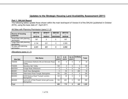
Summary of potential housing supply (para 4.1.2)Small Sites withplanning permissionLarge Sites withplanning permission<strong>2011</strong>/12–2015/162016/17–2020/212021/22–2025/2026Total197 0 0 1972,134 221 0 2,355Allocations 490 715 0 1,205Site specific sources(identified throughsurvey)341 729 95 1,164Small site windfall 0 0 250 250Total supply 3,162 1,665 345 5,171Note: The remaining tables in Version 6 of the <strong>SHLAA</strong>, which set out information relating to greenfield sites, have notbeen updated as these sites have been taken forward through the LDF Core Strategy process. They are not relevant forl<strong>and</strong> supply purposes associated with the AMR at this stage given that this is concerned with sites with planningpermission, site allocations <strong>and</strong> brownfield/ previously developed l<strong>and</strong> rather than new greenfield sites which will need tobe allocated through the LDF process.4 of 36
Harrow Garage Headley 27 0 0 10 17 0 0 0 0 0 0 0Clifton House,Bunnian Place <strong>Basingstoke</strong> 205 0 0 0 0 0 0 0 0 0 0 205The site meets the SAA tests. An application (BDB72121) toextend the time limit of the original application was approved<strong>and</strong> limited work on site commenced in summer 2010. The sitenow has a new owner <strong>and</strong> the details of the scheme are beingreviewed. Also, as the commercial element will be providedfirst, completions are not expected until 2013/4. The schemeincludes 8 affordable units.The site has a full 5 year consent for 205 units (BDB54937) <strong>and</strong>is suitable for housing (expires July 2012). However, the siteagent (Cromwell Holding Ltd) does not consider the site to meetthe availability <strong>and</strong> achievability tests of PPS3 as the freehold isowned by the borough council <strong>and</strong> the head lease does notallow the use granted by the planning consent. In addition theeconomic climate has resulted in the building being relet for anemployment use. The site therefore no longer meets the SAAtests <strong>and</strong> it is considered unlikely that the permission will beimplemented.Worting CountyInfant School <strong>Basingstoke</strong> 3 3 0 0 0 0 0 0 0 0 0 011-19 GreytownHouse, Wote St <strong>Basingstoke</strong> 24 0 0 24 0 0 0 0 0 0 0 0Ash Rd, BeechRd, Linden Rd,Willow RdBishopsGreen 63 63 0 0 0 0 0 0 0 0 0 019-21 SoperGrove <strong>Basingstoke</strong> 13 11 0 0 0 0 0 0 0 0 0 2Under construction - meets the SAA tests. The 3 remainingunits of this larger site are being completed by Kingsoak <strong>and</strong>are due to be complete in <strong>2011</strong>/12 with monitoring confirmingthat there are starts on all of the units.The site meets the SAA tests. An application to extend thecurrent planning permission was granted in May 2010(BDB/72108). The developer's (T.A. Fisher) response to thesite monitoring consultation indicates completion in 2012/13but, for annual monitoring purposes, a more conservativeapproach has been taken which pushes completions back 12months. The site has previously been delayed as a result ofthe slow down in both the economic <strong>and</strong> local property marketswhich have affected the viability of the site.Under construction - meets the SAA tests. The developer's(Sentinel <strong>and</strong> Hill Partnership) response to the site monitoringconsultation indicates that Phase 3 is underway <strong>and</strong> the site willbe completed in <strong>2011</strong>/12. This statement is supported byinformation held by Housing Services <strong>and</strong> the monitoring ofstarts on site.The site meets the SAA tests. One of the flats has beencompleted <strong>and</strong> the ground floor flats were complete at the timeof monitoring. There is, however, a current application(BDB72788 - retrospective) being dealt with for 12 rather than14 flats (due to the roof height being lower <strong>and</strong> only 2 beingbuilt in the roof space). It is considered that the remaining flatswill be completed in <strong>2011</strong>/12 once the issue with the upper flatshas been resolved.7 of 36
Beech Down Preschool <strong>Basingstoke</strong> 134 64 0 0 30 40 0 0 0 0 0 0Maldive/FaroeClose <strong>Basingstoke</strong> 208 173 35 0 0 0 0 0 0 0 0 0Harts Lane Burghclere 18 18 0 0 0 0 0 0 0 0 0 0Broadview,Woods Lane. Cliddesden 10 0 10 0 0 0 0 0 0 0 0 0RooksdownPractice, MillRoad, ParkPrewett <strong>Basingstoke</strong> 14 14 0 0 0 0 0 0 0 0 0 0Kempshott ParkIndustrial Estate <strong>Basingstoke</strong> 62 0 0 0 30 32 0 0 0 0 0 0Laverstoke Mill Laverstoke 72 0 0 0 0 0 0 0 0 0 0 72The site meets the SAA tests <strong>and</strong> is under construction. 64 ofthe units are care home units for the elderly <strong>and</strong> this element ofthe development will be provided first. Delivery rates reflectinformation held by Housing Services <strong>and</strong> that provided throughthe site monitoring consultation (Sayon Weald Homes Ltd)which confirmed completion in this monitoring year. Timescalesfor completions on this aspect of the site reflects informationsubmitted by the l<strong>and</strong>owner (HCC) in their response to the sitemonitoring consultation although a more conservative approachhas been taken given the nature of the site etc. The permissionis for up to 70 units but this may fall to around the 60 mark.Under construction - the site meets the SAA tests. 29 unitswere completed on the site in 2010/11 with 120 losses. Phasingof the remainder of this regeneration scheme takes account ofinformation held by housing services, the 3 year buildprogramme put forward by the developers (Sentinel, HillPartnership Ltd) in response to the site monitoring consultation,<strong>and</strong> monitoring of development on site.Under construction - the site meets the SAA tests. Thedeveloper (Bewley Homes) has confirmed through the sitemonitoring consultation that all of the units are due to becompleted by August <strong>2011</strong>.The site received outline planning permission in June 2010 for10 units (BDB72148) <strong>and</strong> an application to amend a number ofsmall details of the scheme (house type etc) was approved inJune <strong>2011</strong> (BDB74000). Bewley Homes have confirmed,through the site monitoring consultation, that they are due to beon site this year <strong>and</strong> that the site will be completed in2012/2013.Under construction - meets the SAA tests. The phasing reflectsthe developer's (Taylor Wimpey) response to the sitemonitoring consultation where they state that the site would becompleted in <strong>2011</strong>/12 at a build rate of 4 units a month.The site received planning permission subject to legalagreement in September 2009 (BDB71030) for 63 dwellings<strong>and</strong> 2,740m2 commercial floorspace. The site meets the SAAtests although there are on-going issues regarding viability (asconfirmed by the planning agents through the housingmonitoring consultation). A conservative approach hastherefore been taken to the timing of completions.The borough council has been made aware that the site hasbeen sold to the Bombay Gin Company who will beredeveloping/converting the site into a distillery. Thispermission will not therefore be implemented <strong>and</strong> the site hasbeen removed from the 15 year l<strong>and</strong> supply.L<strong>and</strong> adjacent to85 BirchesCrescent <strong>Basingstoke</strong> 11 0 11 0 0 0 0 0 0 0 0 0Site meets the SAA tests. The site was given permission for 11units in February <strong>2011</strong> (BDB73474). Phasing reflects typicalcompletion rates for greenfield sites of this nature.9 of 36
Total LargePermissions 2714 662 346 396 410 320 158 31 32 0 0 359Total SmallPermissions All 197 40 40 39 39 39 0 0 0 0 0 0TotalCommitments 2911 702 386 435 449 359 158 31 32 0 0 359Notes1. The dwelling yields <strong>and</strong> phased completions have been agreed between BDBC <strong>and</strong> HCC2. The 'status/comments’ column refers to the 'SAA' tests. These relate to sites being required to be 'suitable, available<strong>and</strong> achievable ' in order to be included in the Borough’s five year l<strong>and</strong> supply. These tests are set out in detail in stage 7of the <strong>SHLAA</strong> methodology <strong>and</strong> PPS3 defines them as follows:- available - the site is available now- suitable - the site offers a suitable location for development now <strong>and</strong> would contribute to the creation of sustainable,mixed communities- achievable - there is a reasonable prospect that housing will be delivered on the site within five yearsAppendix 2: Table of Rejected Sites (additional to existing appendix)The following sites are added to the list of rejected sites listed in Appendix 2. The information follows the same format asthat used in Version 6 of the <strong>SHLAA</strong>. Sites that have not previously been considered through the <strong>SHLAA</strong> (i.e. new sites)are highlighted in bold, whilst the remaining sites are those that have previously been included in other appendices of the<strong>SHLAA</strong> but which, through the annual monitoring process, have been identified as no longer representing a developmentopportunity.Site Ref Site Name Settlement Reason for Rejection<strong>Basingstoke</strong>BAS017Chineham TradingCentre, 1 Reading Roadthe availability tests.BAS056Church, Wessex Close<strong>Basingstoke</strong>The site is in multiple tenancies <strong>and</strong> the ownership of the site is unknown. There hasbeen no recent developer interest. It is therefore considered that the site no longer meetsAlthough there is known developer interest in the site, given its constrained nature it isconsidered that the site would yield less than 5 dwellings. The <strong>SHLAA</strong> does not include10 of 36
impact on the area. The <strong>SHLAA</strong> does not include sites with a potential yield of lessthan 5 units <strong>and</strong> therefore the site has been rejected.<strong>Basingstoke</strong> The site has been promoted on behalf of Royal Mail Group Limited who have a 66year lease from BDBC who own the site. The site lies within the Priestly RoadBusiness Park, part of the wider Houndmills Industrial Estate, a designatedemployment area, where B2 <strong>and</strong> B8 uses are dominant. The site is currently inoperational use. Whilst the area has a separate identity from the rest of theIndustrial Estate <strong>and</strong> there are some vacancies in this area (which are beingBAS138<strong>Basingstoke</strong> DeliveryOffice, Hermes Roadmonitored), the overall conclusion of the ELR was that the area is a well definedemployment area which should be retained for employment use.Bramley The site is now being considered for solely a community use, with some residentialBRAM007British Legion ClubGrounds/Car Parkdevelopment potentially being provided on the existing village hall site in Bramley instead(totalling 3-4 units). Therefore this site is no longer available for a residential use.Kingsclere The site is owned by the borough council but is no longer being actively pursued forKING006 24 Swan Streetresidential development. The site has been fully let to various office uses <strong>and</strong> a dancestudio. Therefore it is no longer available for a residential use.Oakley The site is likely to be in multiple ownership <strong>and</strong> there is no evidence of developerOAK007 L<strong>and</strong> at Andover Roadinterest in recent years. The availability of the site is therefore questionable. NB: giventhe removal of back gardens from PPS3 this is no longer categorised as a brownfieldsite.Tadley In light of the Boundary Hall appeal, all additional brownfield sites within Tadley, with theTAD001 Franklin Avenueexception of Mulfords Hill, have been removed from the l<strong>and</strong> supply in line with thepublished position statement of July <strong>2011</strong>.Tadley In light of the Boundary Hall appeal, all additional brownfield sites within Tadley, with theTAD005 30 Mount Pleasantexception of Mulfords Hill, have been removed from the l<strong>and</strong> supply in line with thepublished position statement of July <strong>2011</strong>.Tadley In light of the Boundary Hall appeal, all additional brownfield sites within Tadley, with theTAD007 38 New Roadexception of Mulfords Hill, have been removed from the l<strong>and</strong> supply in line with thepublished position statement of July <strong>2011</strong>.Tadley The site lies within the Settlement Policy Boundary for Tadley <strong>and</strong> is not coveredby any other local plan designation. The site has been promoted by BNP RealParibas Estate on behalf of Royal Mail Group Limited who have, they say, a 66 yearlease from BDBC. However, there is no record of BDBC owning the site. The site isTAD040Tadley Delivery Office.Newchurch Road,Tadleyin operational use. In light of the Boundary Hall appeal, all additional brownfieldsites within Tadley, with the exception of Mulfords Hill, have been removed fromthe l<strong>and</strong> supply in line with the published position statement of July <strong>2011</strong>.RBS001 Laverstoke Mill Laverstoke There is no longer interest to redevelop the site for a residential use as it is being12 of 36
(ruralbrownfield)pursued for a distillery. Therefore it is no longer available.Appendix 3: Sites Identified as Having Housing Potential on Previously Developed L<strong>and</strong> <strong>and</strong>/or within SettlementPolicy Boundaries (additional to existing appendix)The proformas <strong>and</strong> maps for appendix 3 have not been updated but see tables above for lists of sites, yields <strong>and</strong> phasing.There is one new site (i.e. it has not previously been considered in the <strong>SHLAA</strong>), to be included in this appendix <strong>and</strong> a newproforma is shown below.siterefBAS137address/locationarea(ha)l<strong>and</strong>owner/agentSite details <strong>and</strong> deliverabilityAurum site 3.8 DP9 The site lies within <strong>and</strong> adjacent to the eastern Settlement Policy Boundary of <strong>Basingstoke</strong> Town(Policy D5) as defined in the ALP <strong>and</strong> within a defined employment area (Hampshire InternationalBusiness Park). The site has been made available for residential use <strong>and</strong> is potentially suitable forresidential development in conjunction with Category 1 <strong>SHLAA</strong> sites to the north. The site is notcurrently in employment use (it has never been used for employment purposes) <strong>and</strong>, subject tomeeting the requirements of Policy EC2, it appears its use for residential may not harm theavailability of employment l<strong>and</strong>. The long-term availability of the site was noted in the EmploymentL<strong>and</strong> Review <strong>and</strong> it was suggested it may suffer from competition from Chineham Business Park <strong>and</strong>possibly Basing View depending on when it was redeveloped.13 of 36
Site Ref. Site Address Settlement/ Site Area (ha)ParishBAS137 The Aurum Site, Lime Tree Way, Hampshire <strong>Basingstoke</strong> 3.8International Business ParkDescription of site (neighbouring uses; present use) Previously Developed L<strong>and</strong>: NoThe site is located to the north of Chineham <strong>and</strong> comprises part of Hampshire InternationalBusiness Park. The site is currently vacant <strong>and</strong> is overgrown. There are two vehicular accesspoints linking the site to Crockford lane on its east <strong>and</strong> west boundaries. The site is boundedby Crockford Lane on its southern, eastern <strong>and</strong> western boundaries <strong>and</strong> to the north liesagricultural l<strong>and</strong>, beyond which lies Razor’s Farm. To the north east of the site is Taylor’sFarm, which is currently being developed for residential use.Relevant Planning HistoryPlanning permission ref. BDB/50218 was granted in August 2003 for the erection of 203,000square foot of B1 office space with l<strong>and</strong>scaping <strong>and</strong> car parking. This planning consent wassubsequently renewed in October 2006 for a further 3 years under ref. BDB/64109, whichthen expired in October 2009.Suitability (policy restrictions/constraints; planning status; physical problems/ limitations;potential impacts; environmental conditions)Policy restrictions/constraints: The site is located within the Settlement Policy Boundary (SPB)of <strong>Basingstoke</strong> Town (Policy D5) as defined in the Adopted Local Plan. The site is also withinHampshire International Business Park, which is an allocated employment area. The loss ofemployment l<strong>and</strong> would need to be justified against the tests of Policy EC2 in order for theprinciple of development to be acceptable. The site is not currently in employment use. Thelong-term availability of the site was noted in the Employment L<strong>and</strong> Review <strong>and</strong> it wassuggested it may suffer from competition from Chineham Business Park <strong>and</strong> possibly BasingView depending on when it was redeveloped.Physical problems: Site does not appear to have any significant constraints however any sitespecific issues would need to be addressed through the planning process.Potential impacts: The close proximity of the site to the railway may cause noise issues whichwould need to be addressed as part of any detailed submission. The site could also currentlyappear visually separate from surrounding residential development given its proximity to thebusiness park. The impact of development on the l<strong>and</strong>scape would need to be carefullymitigated.Availability (legal/ownership issues)There is known developer interest in the site. It is therefore considered available fordevelopment.Achievability (economic viability; market factors; cost factors; delivery factors)Subject to compliance with Policy EC2, the site is suitable in principle <strong>and</strong> consideredavailable for development. Subject to detailed design issues, the site could come forward inthe next 0-5 years.Conclusion (Deliverable / Developable)The site is acceptable in principle subject to the tests of Policy EC2 being met. The site meetsthe deliverability tests set out in national guidance in that the site is available now, offers asuitable location for housing development <strong>and</strong> there is a reasonable prospect that housing willbe delivered on the site within five years.Potential Density <strong>and</strong> Yield (including development type)Based on information submitted to date, the site has a potential yield of approximately 150dwellings (40dph).Phasing: 0-5 years 5-10 years 10-15 years15014 of 36
15 of 36
Appendix 4: Greenfield Sites Assessed for Potential for Housing Outside Settlement Policy Boundaries(additional to existing appendix for category 1 <strong>and</strong> category 2, <strong>and</strong> replacement for category 3 sites)Category 1 <strong>and</strong> 2 proformas <strong>and</strong> maps have not been updated. New sites (i.e. those which have not previously beenconsidered in the <strong>SHLAA</strong>) to be included in category 1 <strong>and</strong> 2 are listed below. All of the maps <strong>and</strong> proformas will beupdated as part of a further updated <strong>SHLAA</strong> which will be produced to inform the Examination into the LDF Core Strategy.Category 1: On the Basis of Current Information Worthy of Further Consideration Through the LDFsite refaddress/locationarea(ha)l<strong>and</strong>owner/agentsite details <strong>and</strong> deliverabilityOV003L<strong>and</strong> westofKingsclereRoad,Overton17.1 HughCrosbieDawsonThe site is an arable field lying to the north of St Mary’s Church <strong>and</strong> had been promotedpreviously (OV003) by Boyer Planning with an option by Barratt Homes. The site had latterlybeen deleted from the <strong>SHLAA</strong> due to developer interest being withdrawn. However, the site isnow being promoted again on behalf of the l<strong>and</strong>owners.OV10WHIT018L<strong>and</strong> atCourtDrove,CourtDrove,OvertonL<strong>and</strong> lyingoffWinchesterRoad,Whitchurch0.8 MarcusNason8 Luken Beckon behalf ofLillybell LtdThe site is located to the north of the main built up part of Overton, <strong>and</strong> comprises twoseparate paddocks which adjoin promoted site OV007. To the west of the site <strong>and</strong> beyondCourt Drove there is residential development <strong>and</strong> the village primary school, whilst to thesouth there are small open fields, Court Farm, St Mary’s Church <strong>and</strong> Court Drove. The siteadjoins the Overton Conservation Area to the south. The site has been promoted by thel<strong>and</strong>owner <strong>and</strong> could be made available for development within a year. Following initialpromotion, the l<strong>and</strong>owner has since stated his wishes for the site to be considered as a jointpromotion with OV007.This site is being promoted on behalf of its single owner as part of a wider area (WHIT017)lying to the south east of Whitchurch, immediately to the east of properties on WhitchurchRoad <strong>and</strong> to the south of residential properties which lie off Micheldever Road. The site lies tothe east of <strong>and</strong> adjoins with Testbourne Community School playing fields. It is locatedoutside the Settlement Policy Boundary (SPB) for Whitchurch as defined under Policy D5 ofthe ALP. It comprises of a number of open fields, lying within a rolling downl<strong>and</strong> l<strong>and</strong>scapeto the south-east of the town.16 of 36
Category 2: Neither Accepted nor Rejected but Requires Further Information <strong>and</strong> Investigationsite refKING011address/locationL<strong>and</strong> onthe southeast side ofSwamStreetarea(ha)l<strong>and</strong>owner/agentsite details <strong>and</strong> deliverability0.35 Mark Offord The site lies to the south of Kingsclere, <strong>and</strong> the majority of the site lies adjacent to, butoutside the Settlement Policy Boundary (SPB) as defined under Policy D5 of the ALP. A smallsection of the south western part of the site falls within the SPB of the settlement. The sitecomprises an area of vacant l<strong>and</strong> to the south east of Swan Street, with pedestrian accessdirectly onto Swan Street. Vehicular access would be subject to local highways authorityapproval. A screen of young trees exists on the north western boundary of the site, whilst theeastern boundary of the site adjoins with a number of residential properties on Fielden Court.The site falls within the Kingsclere Conservation Area <strong>and</strong> therefore consideration wouldneed to be given to Policy E3 of the ALP.Category 3: Schedule of rejected sites - currently not demonstrating the ability to contribute to the creation ofsustainable communities. (New sites shown in bold)New sites, not previously considered in the <strong>SHLAA</strong>, are shown in bold. Comments reflect the existing approach <strong>and</strong>wording used for sites <strong>and</strong> settlements in Version 6 of the <strong>SHLAA</strong>. As the <strong>SHLAA</strong> states, it is for the LDF to determinewhich settlements should accommodate further growth <strong>and</strong> which sites are suitable for development, <strong>and</strong> this appendix,along with the rest of the document, will be updated in due course to take account of decisions made through the LDFrelating to site <strong>and</strong> distribution work, future reviews of Settlement Policy Boundaries <strong>and</strong> neighbourhood planning. Afootnote has been added to each of the new sites to reflect this position. This table also now includes sites previouslylisted in appendix 5 of Version 6 of the <strong>SHLAA</strong> entitled ‘Additional Sites Identified from October 2008 Draft <strong>SHLAA</strong>Consultation: Rejected Sites - Currently not Demonstrating the Ability to Contribute to the Creation of SustainableCommunities (same status as category 3 sites in appendix 4)’.17 of 36
site refASH001BAS100address/locationL<strong>and</strong> north ofChapel Lane,Ashford HillKingsclereRoadarea(ha)l<strong>and</strong>owner/agentImpstoneDevelopmentsHomes <strong>and</strong>CommunitiesAgencyBAS101 Black Dam 44 Bell Cornwell/<strong>Basingstoke</strong><strong>and</strong> DeaneBoroughCouncilsite details <strong>and</strong> deliverabilityThe site lies to the north of Ashford Hill, outside the Settlement Policy Boundary (SPB) asdefined under Policy D5 of the ALP. The site is a long narrow field. Ashford Hill is notconsidered to be a sustainable location where a new housing allocation would be encouraged.Access to the site is sub-st<strong>and</strong>ard. Therefore, the site does not demonstrate the ability tocontribute towards sustainable development.The site lies to the north west of <strong>Basingstoke</strong>, outside of the Settlement Policy Boundary (SPB)as defined under Policy D5 of the ALP <strong>and</strong> lies to the north of the area promoted as West<strong>Basingstoke</strong> MDA <strong>and</strong> could be considered to be an extension. However, given the capacity ofthe West <strong>Basingstoke</strong> MDA (which could accommodate in the region of 8,000 dwellings) there isunlikely to be a requirement for this site for a considerable period of time.A significant part of the site is designated as a Site of Importance for Nature Conservation(SINC), Basing Fen, <strong>and</strong> much of the site is subject to flood constraints. Given these issues <strong>and</strong>the limited availability of access to the site, it does not demonstrate the ability to contributetowards sustainable developmentBAS113BAS120BAS123CarpentersFarm,CrockfordLanePeak Copse,DummerWest LaneFarm21.5 Morgan Cole The site forms a part of the Basing Forest Site of Importance for Nature Conservation (SINC),<strong>and</strong> falls outside of the Settlement Policy Boundary (SPB) as defined under Policy D5 of theALP. The Inspector at the last Local Plan Inquiry found that the nature conservation value of thesite weighed strongly against its development. A planning appeal for office use was dismissedin 2000. This area should only be considered for development if the Borough’s housingrequirements to 2026 cannot be met on other more suitable sites.14.5 HampshireCounty Council51.6 HampshireCounty CouncilThe site consists of a former Hampshire County Council highway depot <strong>and</strong> gypsy site, <strong>and</strong> fallsoutside of the Settlement Policy Boundary (SPB) as defined under policy D5 of the ALP. Thesite is largely wooded <strong>and</strong> poorly related to the urban area of <strong>Basingstoke</strong> <strong>and</strong> distant fromservices <strong>and</strong> facilities. The site is not considered to be suitable for new housing development.The site forms part of West Lane Farm in agricultural use, outside of the Settlement PolicyBoundary (SPB) as defined under policy D5 of the ALP. Development would result in thecoalescence of Sherborne St John <strong>and</strong> <strong>Basingstoke</strong>, which are currently distinct <strong>and</strong> separatesettlements. The site is considered to be unsuitable for new housing development.18 of 36
BAS128Basing LimePits5 <strong>Basingstoke</strong><strong>and</strong> DeaneBoroughCouncilThis site is adjacent to BAS101 <strong>and</strong> falls outside of the Settlement Policy Boundary (SPB) asdefined under policy D5 of the ALP. The area comprises of ab<strong>and</strong>oned <strong>and</strong> overgrownopencast extraction works <strong>and</strong> contains two parks <strong>and</strong> fitness trail <strong>and</strong> so is considered to be inactive recreation use. Much of the l<strong>and</strong> is subject to flood constraints <strong>and</strong> the EnvironmentAgency objected to the inclusion of this site on flood <strong>and</strong> potential contamination grounds.Given the constraints of the site <strong>and</strong> its status as an area of open space, it is considered to beunsuitable for new housing development.BAS131BAS135BCAN001BRAM006BRAM010L<strong>and</strong>adjacent toWeybrookgolf course,RooksdownSports Fieldat Water End,near<strong>Basingstoke</strong>L<strong>and</strong>adjacent toRobey’sFarm,BrownC<strong>and</strong>overChurchFarm,BramleyL<strong>and</strong> north ofBramleyGreen1.8 Mr Sweeney This is an isolated field, lying adjacent to a golf course outside of the Settlement PolicyBoundary (SPB) as defined under policy D5 of the ALP. The site lies west of the Park Prewettdevelopment, from which it is separated by the Spinney, a thick belt of mature trees, whichforms a very clear boundary between the open countryside <strong>and</strong> the urban area in this area.Given the degree of separation with the urban area <strong>and</strong> the rural character of the site, the site isconsidered to be unsuitable for new housing development.Linde Holdings0.32 SouthernPlanningPractice onbehalf of Mr PScott0.73 Simmons &Sons13.4 DreweattNeate/Stratfield SayeEstateSite is outside <strong>and</strong> not adjacent to a settlement policy boundary. Development would result inan inappropriate extension into the countryside <strong>and</strong> the site is therefore not considered to havepotential for residential development.The site lies within the village of Brown C<strong>and</strong>over, <strong>and</strong> lies outside of any SettlementPolicy Boundary (SPB) as defined under Policy D5 of the ALP. Brown C<strong>and</strong>over is aninappropriate location for large scale housing development, which should be directed tomore sustainable <strong>and</strong> accessible locations (small sites accommodating less than 5 unitsare outside the scope of the <strong>SHLAA</strong>).*The site lies outside of the Settlement Policy Boundary (SPB) as defined under policy D5 of theALP, within a conservation area <strong>and</strong> includes a number of agricultural buildings which may besuitable for con<strong>version</strong>. Even if Bramley is considered through the LDF to be a suitablesettlement for growth, this site is unsuitable for development because of its rural setting, locationwithin a conservation area <strong>and</strong> constraints of the existing buildings..The site lies outside of the Settlement Policy Boundary (SPB) as defined under policy D5 of theALP, adjacent to a conservation area, currently in agricultural use. Even if Bramley isconsidered through the LDF to be a suitable settlement for growth, this site relates poorty to thebuilt up area <strong>and</strong> because of its effect on the rural character of the area.BRAM011Beech Farm,Bramley1.2 DreweattNeateThe site lies outside of the Settlement Policy Boundary (SPB) as defined under policy D5 of theALP, within the Bramley Green conservation area <strong>and</strong> provides a green <strong>and</strong> open separation19 of 36
CCAN001CLID 001Green between two built-up areas. Even if Bramley is considered through the LDF to be a suitablesettlement for growth, this site is considered to be important to the setting of the settlement thatshould be protected.L<strong>and</strong>adjacent toGravelClose,ChiltonC<strong>and</strong>overFarleighRoad,Cliddesden5.2 Susan Marriot The site lies to the south west of Chilton C<strong>and</strong>over, <strong>and</strong> lies outside of any SettlementPolicy Boundary (SPB) as defined under Policy D5 of the ALP. Chilton C<strong>and</strong>over is aninappropriate location for large scale housing development, which should be directed tomore sustainable <strong>and</strong> accessible locations.*3.45 Simmons &SonsCLID002 Church Farm 0.82 Simmons &SonsCLID 003CLID 004CLID 005BrambleBank,Farleigh Rd,CliddesdenWoods LaneScrapyard,CliddesdenChurch Lane,CliddesdenCliddesden is an inappropriate location for large scale housing development, which should bedirected to more sustainable <strong>and</strong> accessible locations within or adjoining the main urban areaswhere there are employment opportunities <strong>and</strong> available services <strong>and</strong> facilities. Development ofthis site would be out of scale with the size of the village.Cliddesden is not considered to be a sustainable location where a new housing allocation wouldbe encouraged. The site does not demonstrate the ability to contribute towards sustainabledevelopment.3.3 Vail Williams Cliddesden is an inappropriate location for large scale housing development, which should bedirected to more sustainable <strong>and</strong> accessible locations within or adjoining the main urban areaswhere there are employment opportunities <strong>and</strong> available services <strong>and</strong> facilities. Development ofthis site would be out of scale with the size of the village.1.0 ShackletonBlackmore2.3 Simmons &SonsCliddesden is an inappropriate location for large scale housing development, which should bedirected to more sustainable <strong>and</strong> accessible locations within or adjoining the main urban areaswhere there are employment opportunities <strong>and</strong> available services <strong>and</strong> facilities. A planningapplication for this site was previously dismissed, where the Inspector highlighted the impact onthe character <strong>and</strong> setting of the village. Accordingly, this site is not considered to be suitable forthe scale of development proposed.Cliddesden is an inappropriate location for large scale housing development, which should bedirected to more sustainable <strong>and</strong> accessible locations within or adjoining the main urban areaswhere there are employment opportunities <strong>and</strong> available services <strong>and</strong> facilities. Development ofthis site would be out of scale with the size of the village.CLID006 Station Road Mr Don Coles Site is outside <strong>and</strong> not adjacent to a settlement policy boundary. Development would result inan inappropriate extension into the countryside <strong>and</strong> the site is therefore not considered to havepotential for residential development.20 of 36
DUM 001ChapelClose,Dummer1.2 Simmons &SonsDummer is an inappropriate location for large scale housing development, which should bedirected to more sustainable <strong>and</strong> accessible locations within or adjoining the main urban areaswhere there are employment opportunities <strong>and</strong> available services <strong>and</strong> facilities. Development ofthis site would be out of scale with the size of the village.KING002KING 003FawconerRoad,KingsclereFrogs Hole,Kingslere0.59 David Wilson The site lies outside of the Settlement Policy Boundary (SPB) as defined under policy D5 of theALP <strong>and</strong> forms one of several sites, making up a continuous strip between the village edge <strong>and</strong>the A339, which was recognised by the Local Plan Inspector as contributing to the ruralcharacter <strong>and</strong> setting of the village. Development would be out of scale with the needs of thevillage <strong>and</strong> is not considered to be appropriate in this location.0.3 David Wilson The site lies outside of the Settlement Policy Boundary (SPB) as defined under policy D5 of theALP <strong>and</strong> forms part of the semi-rural character of the edge of the village, as noted by the LocalPlan Inspector. Development would be out of scale with the needs of the village <strong>and</strong> is notconsidered to be appropriate in this location.KING 004Kevin Close,Kingsclere1.3 <strong>Basingstoke</strong><strong>and</strong> DeaneBoroughCouncilThe site lies outside of the Settlement Policy Boundary (SPB) as defined under policy D5 of theALP <strong>and</strong> forms one of several sites, making up a continuous strip between the village edge <strong>and</strong>the A339, which was recognised by the Local Plan Inspector as contributing to the ruralcharacter <strong>and</strong> setting of the village. The site is owned by BDBC <strong>and</strong> was obtained as publicopen space through a s106 agreement, <strong>and</strong> is therefore not considered appropriate forresidential development following the Council Motion of 2 April 2009. Furthermore, developmentwould be out of scale with the needs of the village <strong>and</strong> is not considered to be appropriate in thislocation.KING 005West ofWinchesterRoad, northof Gaily Mill,Kingsclere2 FramptonsPlanning forMiddleton &Portway EstateThe site lies outside of the Settlement Policy Boundary (SPB) as defined under policy D5 of theALP, within the conservation area <strong>and</strong> is in an area where there is little containment.Development would result in an inappropriate extension into the countryside.KING 006L<strong>and</strong>comprisingpart of FieldBarn,Kingsclere13.5 FramptonsPlanning forMiddleton &Portway EstateThe site lies outside of the Settlement Policy Boundary (SPB) as defined under policy D5 of theALP, within the conservation area <strong>and</strong> is in an area where there is little containment.Development would result in an inappropriate extension into the countryside.KING 007L<strong>and</strong>betweenA339BruceWilliamsonThe site lies outside of the Settlement Policy Boundary (SPB) as defined under policy D5 of theALP <strong>and</strong> forms one of several sites, making up a continuous strip between the village edge <strong>and</strong>the A339, which was recognised by the Local Plan Inspector as contributing to the rural21 of 36
KING 009KING010MS001NEW 001NWAL 001NWAL001ballotments &LongcroftRoad,KingslcereNorth ofFoxes Lane,part of FieldBarn Farm,KingsclereL<strong>and</strong> north ofChestnutCottage,HeadleyKiln L<strong>and</strong>Cottages ,MonkSherborneL<strong>and</strong> offCrown Lane,NewnhamL<strong>and</strong> atWestsideDairy, NorthWalthamL<strong>and</strong> atWestsideDairy, North13.5 FramptonsPlanning forMiddleton &Portway Estate8.37 Harry WestInvestments0.33 Smiths Goreon behalf ofPheasant EyeLtd3.8 Morse WebbArchitects / MrW Winton4.6 Sweeney& Birchcharacter <strong>and</strong> setting of the village. Development would be out of scale with the needs of thevillage <strong>and</strong> is not considered to be appropriate in this location.The site lies outside of the Settlement Policy Boundary (SPB) as defined under policy D5 of theALP, within the North Wessex Downs AONB <strong>and</strong> is an area where there is little selfcontainment. Development would result in an inappropriate extension into the countryside.Site is outside, <strong>and</strong> not adjacent to, a settlement policy boundary. Development would result inan inappropriate extension into the countryside <strong>and</strong> the site is therefore not considered to havepotential for residential development.The site lies to the north west of Monk Sherborne but outside of any Settlement PolicyBoundary (SPB) as defined under Policy D5 of the ALP. The site comprises a number ofcottages known as Keepers Cottages <strong>and</strong> Nos 1 <strong>and</strong> 2 <strong>and</strong> residential gardens. It isconsidered that Monk Sherborne is an inappropriate location for large scale housingdevelopment, which should be directed to more sustainable <strong>and</strong> accessible locations.*Newnham is an inappropriate location for large scale housing development, which should bedirected to more sustainable <strong>and</strong> accessible locations within or adjoining the main urban areaswhere there are employment opportunities <strong>and</strong> available services <strong>and</strong> facilities. The site isdistant from any Settlement Policy Boundary <strong>and</strong> is not in a sustainable location for newhousing. Therefore, the site is considered to be unsuitable for new housing development.North Waltham is an inappropriate location for large scale housing development, which shouldbe directed to more sustainable <strong>and</strong> accessible locations within or adjoining the main urbanareas where there are employment opportunities <strong>and</strong> available services <strong>and</strong> facilities. Only a partof this site is being suggested for development by the l<strong>and</strong>owner, which is located within theconservation area <strong>and</strong> was rejected for development by the Local Plan Inquiry for reasons ofharm to the character of the area. Development would be inappropriate in this location given thesize of the site <strong>and</strong> its location within the conservation area.0.6 Bevans Evans North Waltham is an inappropriate location for large scale housing development, which shouldbe directed to more sustainable <strong>and</strong> accessible locations within or adjoining the main urbanareas where there are employment opportunities <strong>and</strong> available services <strong>and</strong> facilities. This siteforms a small part of a wider site, which is located within the conservation area <strong>and</strong> was rejected22 of 36
NWAL 002NWAL 003OLD002OLD003OLD004OAK001WalthamSouth westof<strong>Basingstoke</strong> /north east ofNorthWalthamL<strong>and</strong> southof StMichael'sClose, NorthWlathamL<strong>and</strong> atNewnhamLane, OldBasingL<strong>and</strong> south ofNewnhamLane, OldBasingL<strong>and</strong> north ofLondonRoad, OldBasingEast ofSainfoinLane325 Carter Jonas /Society ofMerchantVenturesFletcherfor development by the Local Plan Inquiry for reasons of harm to the character of the area.Development would be inappropriate in this location given the size of the site <strong>and</strong> its locationwithin the conservation area.North Waltham is an inappropriate location for large scale housing development, which shouldbe directed to more sustainable <strong>and</strong> accessible locations within or adjoining the main urbanareas where there are employment opportunities <strong>and</strong> available services <strong>and</strong> facilities.Development would be inappropriate in this location given the significant size of the site <strong>and</strong> theimpact on the countryside.North Waltham is an inappropriate location for large scale housing development, which shouldbe directed to more sustainable <strong>and</strong> accessible locations within or adjoining the main urbanareas where there are employment opportunities <strong>and</strong> available services <strong>and</strong> facilities. The siteconsists of a large field, which is being promoted for just two dwellings, which would be belowthe study threshold.1.8 Till The site lies outside of the Settlement Policy Boundary (SPB) as defined under policy D5 of theALP <strong>and</strong> comprises paddocks that lie between some sporadic detached dwellings to the east ofOld Basing, <strong>and</strong> Lower Mill Farm to the west. It is not adjacent to a Settlement Policy Boundary<strong>and</strong> is not considered to be an appropriate location for housing development, with a poorrelationship to the built up area.41.78 W.A.T.Stacy <strong>and</strong>Partners25.74 W.A.T.Stacy <strong>and</strong>PartnersSite is outside <strong>and</strong> not adjacent to a settlement policy boundary for Old Basing. Developmentwould result in an inappropriate extension into the countryside <strong>and</strong> the site is therefore notconsidered to have potential for residential development.Site is outside <strong>and</strong> not adjacent to a settlement policy boundary for Old Basing. Developmentwould result in an inappropriate extension into the countryside <strong>and</strong> the site is therefore notconsidered to have potential for residential development.1.74 Oakley is an inappropriate location for large scale housing development, which should bedirected to more sustainable <strong>and</strong> accessible locations within or adjoining the main urban areaswhere there are employment opportunities <strong>and</strong> available services <strong>and</strong> facilities. The siteconsists of paddocks <strong>and</strong> rear gardens <strong>and</strong> development in this location would be inappropriate<strong>and</strong> only small sites for local housing needs should be considered.OAK002 Fairview 1.4 Simmons & Oakley is an inappropriate location for large scale housing development, which should be23 of 36
OAK003OAK005Meadow,SainfoinLaneWest ofSainfoinLaneCedarLodge, BarnLaneSons6.5 ShackletonBlackmore0.4 DGG Planning- Area 6 inadopted LocalPlanOAK006 Park Farm 4.5 Judith AshtonAssociatesOAK007OAK009OAK010L<strong>and</strong> atSanfoinLane, OakleyL<strong>and</strong> atBeech TreeClose,OakleyL<strong>and</strong> to therear if theVillage Hall,Oakley0.08 Mr <strong>and</strong> MrsM.Ryan5.0 GleesonStrategicL<strong>and</strong>1.0 Brimble, Lea& Partnersdirected to more sustainable <strong>and</strong> accessible locations within or adjoining the main urban areaswhere there are employment opportunities <strong>and</strong> available services <strong>and</strong> facilities. The site offerspoor access via an unadopted track <strong>and</strong> development in this location would be inappropriate <strong>and</strong>only small sites for local housing needs should be consideredOakley is an inappropriate location for large scale housing development, which should bedirected to more sustainable <strong>and</strong> accessible locations within or adjoining the main urban areaswhere there are employment opportunities <strong>and</strong> available services <strong>and</strong> facilities. Development ofthis site would extend the village into the open countryside <strong>and</strong> would be inappropriate <strong>and</strong> onlysmall sites for local housing needs should be consideredOakley is an inappropriate location for large scale housing development, which should bedirected to more sustainable <strong>and</strong> accessible locations within or adjoining the main urban areaswhere there are employment opportunities <strong>and</strong> available services <strong>and</strong> facilities. Development ofthis site would extend the village into the open countryside <strong>and</strong> would be inappropriate <strong>and</strong> onlysmall sites for local housing needs should be consideredOakley is an inappropriate location for large scale housing development, which should bedirected to more sustainable <strong>and</strong> accessible locations within or adjoining the main urban areaswhere there are employment opportunities <strong>and</strong> available services <strong>and</strong> facilities. Development ofthis site would extend the village into the open countryside <strong>and</strong> would be inappropriate <strong>and</strong> onlysmall sites for local housing needs should be consideredThe site area is not sufficient to achieve the <strong>SHLAA</strong>’s dwelling yield threshold of five units.Oakley is an inappropriate location for large scale housing development, which should bedirected to more sustainable <strong>and</strong> accessible locations. The site lies adjacent to theSettlement Policy Boundary (SPB) as defined by Policy D5 of the ALP <strong>and</strong> OAK005 whichis also a category 3 site. Development of this site would extend the village into the opencountryside <strong>and</strong> only small sites for local housing needs should be considered.*The site currently consists of allotments (currently leased to the Parish Council) <strong>and</strong>paddock. Oakley is an inappropriate location for large scale housing development, whichshould be directed to more sustainable <strong>and</strong> accessible locations. The site lies outside ofthe Settlement Policy Boundary (SPB) as defined by Policy D5 of the ALP, to the west ofthe northern part of Oakley <strong>and</strong> would inappropriately extend the village into the opencountryside.*24 of 36
OV008L<strong>and</strong>adjacent toWillerseyWarrenCottage,OvertonMiddleton <strong>and</strong>Portway EstateSite is outside <strong>and</strong> not adjacent to a settlement policy boundary. Development would result inan inappropriate extension into the countryside <strong>and</strong> the site is therefore not considered to havepotential for residential development.OV009PCAN001L<strong>and</strong> to thenorth of theOverton Cof E PrimarySchoolL<strong>and</strong>adjacent toChurchFarm, WieldRoad,PrestonC<strong>and</strong>over1.7 MWA Project& FacilitiesManagement2.2 LawrenceNardiThe site is located to the north of the main built up part of Overton <strong>and</strong> lies outside thevillage’s Settlement Policy Boundary, as defined in the ALP. The site comprises a parcelof l<strong>and</strong> which shares access with a two large detached properties which adjoin with thenorthern boundary of the site. The site has been promoted by the l<strong>and</strong>owner for a singledwelling. As the <strong>SHLAA</strong> only considers sites of 5 or more units, the site does not fallwithin the parameters of the assessment <strong>and</strong> is therefore rejected. Development wouldalso lead to an inappropriate isolated pocket of development.*The site lies to the south of Preston C<strong>and</strong>over, outside the Settlement Policy Boundary(SPB) as defined under Policy D5 of the ALP. The site also falls within the PrestonC<strong>and</strong>over Conservation Area. Preston C<strong>and</strong>over is an inappropriate location for largescale housing development, which should be directed to more sustainable <strong>and</strong>accessible locations.*PE001L<strong>and</strong> atPamber End0.9 Chart PlanLimitedThe site lies adjacent to the village of Pamber End but outside of any Settlement PolicyBoundary (SPB) as defined under Policy D5 of the ALP. Pamber End is an inappropriatelocation for large scale housing development, which should be directed to moresustainable <strong>and</strong> accessible location.*PE002PamberPlace,Pamber EndRAM001 34<strong>Basingstoke</strong>Road,Ramsdell0.8 Chart PlanLimited0.1 Pheasant EyeLtdThe site comprises an isolated Grade II listed building which the promoter is seeking toconvert. However, it is considered that Pamber End is an inappropriate location foradditional significant housing development, which should be directed to moresustainable <strong>and</strong> accessible locations. The site is distant from any Settlement PolicyBoundary <strong>and</strong> is not in a sustainable location for new housing.*The site lies some distance to the south of Ramsdell village <strong>and</strong> lies outside of anySettlement Policy Boundary (SPB) as defined under Policy D5 of the Adopted Local Plan.The area of l<strong>and</strong> consists of a residential property <strong>and</strong> garden on the western side of<strong>Basingstoke</strong> Road. Ramsdell is an inappropriate location for large scale housing25 of 36
Tadleydevelopment, which should be directed to more sustainable <strong>and</strong> accessible locations.*SOL 003GossardsLane6.5 Simmons &SonsSherfield-on-Loddon is an inappropriate location for large scale housing development, whichshould be directed to more sustainable <strong>and</strong> accessible locations within or adjoining the mainurban areas where there are employment opportunities <strong>and</strong> available services <strong>and</strong> facilities.SOL 004SOL005SOL007SOL008SOL009South Westof Sherfieldon-LoddonL<strong>and</strong> northeast ofSherfieldCourt,Sherfield-on-LoddonSouth westof Sherfieldon-Loddon,north ofRedl<strong>and</strong>s,east ofTaylor FarmL<strong>and</strong> atSherfield HillFarm,<strong>Basingstoke</strong>Road,Sherfield onLoddonL<strong>and</strong>Adjacent to5.1 Simmons &Sons8.2 PlanningPerspectivesLLP/ MssrsThorne,Edwards,Barker, HoldenSimmons &Sons forBowaterDevelopment of this site would extend the village into the open countryside <strong>and</strong> would beinappropriate <strong>and</strong> only small sites for local housing needs should be considered.Sherfield-on-Loddon is an inappropriate location for large scale housing development, whichshould be directed to more sustainable <strong>and</strong> accessible locations within or adjoining the mainurban areas where there are employment opportunities <strong>and</strong> available services <strong>and</strong> facilities.Development of this site would extend the village into the open countryside <strong>and</strong> would beinappropriate <strong>and</strong> only small sites for local housing needs should be considered.Sherfield-on-Loddon is an inappropriate location for large scale housing development, whichshould be directed to more sustainable <strong>and</strong> accessible locations within or adjoining the mainurban areas where there are employment opportunities <strong>and</strong> available services <strong>and</strong> facilities.The site is distant from <strong>and</strong> unrelated to any settlement <strong>and</strong> development of this site would beinappropriate <strong>and</strong> only small sites for local housing needs should be considered.This site is adjacent to site SOL002 which is included as a category 1 site, that is, it has housingdevelopment potential <strong>and</strong> is worthy of further consideration through the LDF. However, this sitewould further extend the built up area into the countryside <strong>and</strong> would represent an unacceptableintrusion.16.91 Mr A.V.Bywater Site is outside <strong>and</strong> not adjacent to the settlement policy boundary for <strong>Basingstoke</strong> or Sherfieldon Loddon. Development would result in an inappropriate extension into the countryside <strong>and</strong> thesite is therefore not considered to have potential for residential development.8.25 Planning Site is outside <strong>and</strong> not adjacent to a settlement policy boundary. Development would result inan inappropriate extension into the countryside <strong>and</strong> the site is therefore not considered to have26 of 36
SSJ001SSJ 003SSJ004TAD012SherfieldCourt,ReadingCourt,ReadingRoad,Church End,Sherfield onLoddonMongersYard, WestEnd,Sherborne StJohnCranesFarm,Sherborne StJohnL<strong>and</strong> at ElmRoad/ManorRoad,SherborneSt JohnL<strong>and</strong> Northof ForestLane, TadleyPerspectives LLP potential for residential development.23.4 Simmons &Sons5.4 DonningtonNew Homes0.7 <strong>Basingstoke</strong><strong>and</strong> DeaneBoroughCouncilSite is outside <strong>and</strong> not adjacent to the settlement policy boundary of Sherborne St John.Development would result in an inappropriate extension into the countryside <strong>and</strong> the site istherefore not considered to have potential for residential development.Sherborne St John is an inappropriate location for large scale housing development, whichshould be directed to more sustainable <strong>and</strong> accessible locations within or adjoining the mainurban areas where there are employment opportunities <strong>and</strong> available services <strong>and</strong> facilities.This site consists of two large arable <strong>and</strong> pasture blocks, <strong>and</strong> development would be bothinappropriate in this location <strong>and</strong> out of scale with the needs of the village. Only small sites forlocal housing should be considered.The site is an arable field on the southern edge of the village, outside but adjacent to theSettlement Policy Boundary (SPB) as defined under Policy D5 of the ALP. Sherborne StJohn is an inappropriate location for large scale housing development, which should bedirected to more sustainable <strong>and</strong> accessible locations. Development of this site wouldextend the village into the open countryside <strong>and</strong> only small sites for local housing needsshould be considered.*This is an open site in agricultural use. The site has defined boundaries <strong>and</strong> is relatively flat. Itlies with the Tadley conservation area <strong>and</strong> also adjacent to a Site of Special Scientific Interest(SSSI) the impact of any development on which would need to be fully assessed. The site hasbeen removed given the current situation with the HSE who is 'advising against' developmentsthat are likely to give rise to a long term net positive increase in population density within theDEPZ in the interests of public safety.** If further development was considered to be suitable atTadley in the future, this site should be assessed further as a possible development site throughthe LDF.27 of 36
TAD013TAD014TAD015TAD017TAD018L<strong>and</strong> West ofGuttridgeLane, TadleyL<strong>and</strong>adjacent toBishopsworthGolf Course,offDeanswoodRoadSmiths Field,DroxfordCrescentBishopswoodLane,BaughurstSouth ofBishopswoodLane, Tadley0.2 <strong>Basingstoke</strong><strong>and</strong> DeaneBoroughCouncil1.6 BartonWilmore forBewley0.7 BoyerPlanning/BloorThe site lies outside of the Settlement Policy Boundary (SPB) as defined under policy D5 of theALP <strong>and</strong> consists of a small green amenity space obtained by <strong>Basingstoke</strong> <strong>and</strong> Deane BoroughCouncil for public open space through a s106 agreement. It is not considered to be appropriatefor residential development following the Council Motion of 2 April 2009 relating to such sites.This site is an undeveloped area which is currently overgrown. The site has been removed giventhe current situation with the HSE who is 'advising against' developments that are likely to giverise to a long term net positive increase in population density within the DEPZ in the interests ofpublic safety.** If further development was considered to be suitable at Tadley in the future, thissite should be assessed further as a possible development site through the LDF.This site comprises of open fields fronting New Road <strong>and</strong> to the west of Droxford Crescent. Thesite has been removed given the current situation with the HSE who is 'advising against'developments that are likely to give rise to a long term net positive increase in population densitywithin the DEPZ in the interests of public safety.** If further development was considered to besuitable at Tadley in the future, this site should be assessed further as a possible developmentsite through the LDF.2.0 Wells The site consists of open undulating fields with strong boundaries. The site is visible from roadsto north <strong>and</strong> east. Bishopswood Lane forms a clear boundary to the urban edge which shouldnot be breached unless with good justification. The site has been removed given the currentsituation with the HSE who is 'advising against' developments that are likely to give rise to a longterm net positive increase in population density within the DEPZ in the interests of publicsafety.** If further development was considered to be suitable at Tadley in the future, this siteshould be assessed further as a possible development site through the LDF process. However,it should be noted that the site is not adjacent to the Tadley SPB but intrudes into the wider opencountryside <strong>and</strong> therefore on the evidence currently available, appears less suitable than othersites promoted around the settlement.14.5 DreweattNeate / Mr PWellsPart of the site has been promoted separately (TAD026). The site is an extensive area ofcountryside partly separating Baughurst from Tadley. The Environment Agency has objected tothis site on grounds of biodiversity. Development here would encroach into open countryside,harming its setting, character <strong>and</strong> appearance. There are therefore considered to be moresustainable options for growth. The site has also been removed given the current situation withthe HSE who is 'advising against' developments that are likely to give rise to a long term netpositive increase in population density within the DEPZ in the interests of public safety.**28 of 36
TAD019L<strong>and</strong> North ofPelicanRoad,PamberHeath,Tadley2.4 Bell Cornwell /Mr <strong>and</strong> Mrs HillThe site lies adjacent to (<strong>and</strong> partly within) the Settlement Policy Boundary to the north of thebuilt-up area of Tadley. It is a typical urban fringe site, with some dilapidated sheds, partovergrown, part scrub, part wooded, <strong>and</strong> operating as a low-key pig smallholding. The site hasbeen removed given the current situation with the HSE who is 'advising against' developmentsthat are likely to give rise to a long term net positive increase in population density within theDEPZ in the interests of public safety.** If further development was considered to be suitable atTadley in the future, this site should be assessed further as a possible development site throughthe LDF.TAD020SilchesterRoad, Tadley(outsideBoroughboundary)20.1 Bell Cornwell /J A PyeHoldings Ltd<strong>and</strong> BovisHomes LtdThe site comprises of a dozen fields in pasture <strong>and</strong> paddocks separated by mature hedges <strong>and</strong>trees. It lies adjacent to, but outside, the Borough boundary, within West Berkshire <strong>and</strong> istherefore not considered further through the <strong>SHLAA</strong>. The Council will need to conclude whetherthere is merit in discussing the site further with Government Office for the South East <strong>and</strong> WestBerkshire Council through the LDF.TAD021TAD024TAD025L<strong>and</strong> N ofForest Close,TadleyL<strong>and</strong> West ofBrimptonRoad,BaughurstBaughurstRd,Baughurst3.8 Strutt & Parker/ The WasingEstateThis site lies south of the B3051 <strong>and</strong> is mainly mature oak plantation. It provides a woodedsetting for the extensive residential areas to the south, <strong>and</strong> acts as an effective buffer betweenthis housing <strong>and</strong> the large employment area Calleva Park, to the north. It is considered to beunsuitable for development. The site has also been removed given the current situation with theHSE who is 'advising against' developments that are likely to give rise to a long term net positiveincrease in population density within the DEPZ in the interests of public safety.**1.9 BDBC The site consists of a four residential properties <strong>and</strong> grounds. The site is located adjacent to thesettlement boundary but is heavily wooded. There is no known developer interest on this site<strong>and</strong> it is unlikely to come forward for development due to its current use <strong>and</strong> wooded nature. Thesite is therefore not currently available for redevelopment. The site has also been removed giventhe current situation with the HSE who is 'advising against' developments that are likely to giverise to a long term net positive increase in population density within the DEPZ in the interests ofpublic safety.**0.55 RPS Planning The site comprises two dwellings with gardens to the east of Baughurst Road. The site isadjacent to <strong>and</strong> immediately south of the Settlement Policy Boundary <strong>and</strong> could form acontinuation of the residential properties on Baughurst Road which run north <strong>and</strong> south of thesite. The site has been removed given the current situation with the HSE who is 'advisingagainst' developments that are likely to give rise to a long term net positive increase inpopulation density within the DEPZ in the interests of public safety.** If further developmentwas considered to be suitable in this area in the future, this site should be assessed further as apossible development site through the LDF, taking into account the more recent development29 of 36
that has taken place in the area since the plan has been adopted.TAD026L<strong>and</strong> E ofBaughurstRd44.5 PegasusPlanningGroupfor RothwellProjectsParts of the site have been promoted separately (TAD017 <strong>and</strong> TAD018 see above). This is anextensive area of countryside separating Baughurst from Tadley, characterised by relativelylarge open arable <strong>and</strong> pasture fields, with some extensive woodl<strong>and</strong>. Most of the area is easilyvisible from Bishopswood Lane, which at present forms a strong urban boundary. Developmenthere would encroach into open countryside, harming its setting, character <strong>and</strong> appearance. Thesite has been removed given the current situation with the HSE who is 'advising against'developments that are likely to give rise to a long term net positive increase in population densitywithin the DEPZ in the interests of public safety.** If further development was considered to besuitable at Tadley in the future, this site should be assessed further as a possible developmentsite through the LDF. However, it should be noted that the development of the site would intrudeinto the wider open countryside <strong>and</strong> therefore on the evidence currently available, appears lesssuitable than other sites promoted around the settlement.TAD027BaughurstRd,Baughurst0.44 Mr IanLasseterThe site comprises two dwellings with gardens to the west of Baughurst Road. The site isadjacent to <strong>and</strong> immediately south of the SPB <strong>and</strong> could form a continuation of the residentialproperties on Baughurst Road which run North <strong>and</strong> South of the site. The site has been removedgiven the current situation with the HSE who is 'advising against' developments that are likely togive rise to a long term net positive increase in population density within the DEPZ in theinterests of public safety.** If further development was considered to be suitable in this area inthe future, this site should be assessed further as a possible development site through the LDF,taking into account the more recent development that has taken place in the area since the planhas been adopted.TAD028TAD029TAD031Dickers,AldermastonRoad,PamberHeath,WakefordPaddock,AldermastonRoad,PamberHeathSt Margarets,Aldermaston0.72 Major W.H.A.<strong>and</strong> Mrs V.A.Knight0.36 Major W.H.A.<strong>and</strong> Mrs V.A.Knight0.31 Major W.H.A.<strong>and</strong> Mrs V.A.Site is outside <strong>and</strong> not adjacent to a settlement policy boundary. Development would result inan inappropriate extension into the countryside <strong>and</strong> the site is therefore not considered to havepotential for residential development.Site is outside <strong>and</strong> not adjacent to a settlement policy boundary. Development would result inan inappropriate extension into the countryside <strong>and</strong> the site is therefore not considered to havepotential for residential development.Site is outside <strong>and</strong> not adjacent to a settlement policy boundary. Development would result inan inappropriate extension into the countryside <strong>and</strong> the site is therefore not considered to have30 of 36
TAD032TAD033TAD034TAD035TAD037TAD038Road,PamberHeathWigmore,AldermastonRoad,PamberHeathOak TreeFarm, LittleLondonL<strong>and</strong> south ofRamsdellRoad,Charter AlleyL<strong>and</strong> atLarkwhistleFarmbetweenBrimptonRoad <strong>and</strong>B3051Baughurst42 TheGreen,TadleyL<strong>and</strong> Northof ShawLane,BaughurstKnight17.6 Major W.H.A.<strong>and</strong> Mrs V.A.KnightMr P.RogersMr SimonBenneyThe WasingEstate24.2 HilberyChaplinpotential for residential development.Site is outside <strong>and</strong> not adjacent to a settlement policy boundary. Development would result inan inappropriate extension into the countryside <strong>and</strong> the site is therefore not considered to havepotential for residential development.Site is outside <strong>and</strong> not adjacent to a settlement policy boundary. Development would result inan inappropriate extension into the countryside <strong>and</strong> the site is therefore not considered to havepotential for residential development.Site is outside <strong>and</strong> not adjacent to a settlement policy boundary. Development would result inan inappropriate extension into the countryside <strong>and</strong> the site is therefore not considered to havepotential for residential development.Site is outside <strong>and</strong> not adjacent to a settlement policy boundary. Development would result inan inappropriate extension into the countryside <strong>and</strong> the site is therefore not considered to havepotential for residential development.Mr Carina Ward Site is too small to meet the <strong>SHLAA</strong> threshold of a net dwelling gain of five dwellingsThis site has also been promoted separately (TAD026) as part of a wider area. This siteconsists of open undulating fields with strong boundaries which forms part of anextensive area separating Baughurst from Tadley. Development here would encroach intoopen countryside, harming its setting, character <strong>and</strong> appearance. The site has beenrejected given the current situation with the HSE who is 'advising against' developmentsthat are likely to give rise to a long term net positive increase in population density withinthe DEPZ in the interests of public safety.** If further development was considered to besuitable at Tadley in the future, this site should be assessed further as a possible31 of 36
TAD039UG001L<strong>and</strong> atBaughurstRoad,BaughurstWestonRoad0.3 Simmons <strong>and</strong>Sons onbehalf ofWinifred Ellis1.43 Simmons &Sonsdevelopment site through the LDF. However, it should be noted that the development ofthe site would intrude into the wider open countryside <strong>and</strong> therefore on the evidencecurrently available, appears less suitable than other sites promoted around thesettlement.*The site lies outside of any Settlement Policy Boundary (SPB) as defined under Policy D5of the ALP. The site comprises a long narrow field which forms part of a wider area withopen fields. The site has been rejected given the current situation with the HSE who is‘advising against’ developments which are likely to give rise to a long term net positiveincrease in population density within the DEPZ in the interests of public safety.** Iffurther development was considered to be suitable at Tadley in the future, this site shouldbe assessed further as a possible development site through the LDF.*Upton Grey is an inappropriate location for large scale housing development, which should bedirected to more sustainable <strong>and</strong> accessible locations within or adjoining the main urban areaswhere there are employment opportunities <strong>and</strong> available services <strong>and</strong> facilitiesThis is a relatively large field on the edge of the village, <strong>and</strong> in view of the above, developmentwould be inappropriate in this location <strong>and</strong> out of scale with the needs of the village. Only smallsites for local housing should be consideredWHIT 008 Bere Hill 27 ha Cluttons This substantial area of l<strong>and</strong> forms the western flanks of a valley on the north-east side ofWhitchurch. The valley sides are steep <strong>and</strong> wooded with sloping pastures above. The easternedge of the site falls within Flood Zone 3. The development of this site would extend the townunnecessarily into open <strong>and</strong> attractive countryside, <strong>and</strong> the scale of development would beinappropriate in Whitchurch even if there is a need for additional allocations. It is unclear how asmaller area could be developed in isolation. There are therefore considered to be moresustainable options for growth.WHIT010BWHIT 012North of TheKnowlings<strong>and</strong> East ofDaniel RoadEast ofBloswoodLane14.6 BDBC This site was part of the larger ‘Knowlings’ site (WHIT010) identified in the draft <strong>SHLAA</strong>. The siteis owned by the borough council <strong>and</strong> due to its use, in part, for active recreational uses (skatepark/BMX <strong>and</strong> a small football area), the borough council considers it is not suitable to beconsidered for future residential development, following the Council Motion of 2 April 2009relating to such sites.2.3 BDBC The site is owned by the borough council <strong>and</strong> was transferred to the council in 2003 pursuant toa Section 106 agreement. It is to be maintained as public open space <strong>and</strong> the borough councilconsiders it is not suitable to be considered for future residential development following theborough council Motion of 2 April 2009 relating to such sites.32 of 36
WHIT 015WHIT 016WHIT017WSL001WSL002WSL003Arnolds FarmLondon RoadL<strong>and</strong> north ofCaesars WayL<strong>and</strong> offWebb FarmClose,WhitchurchUpper Farm,Wootton StLawrence,<strong>Basingstoke</strong>TheChestnuts,Wootton StLawrenceManor Farm,Wootton StLawrenceMichael &AnneFitzgeraldDreweattNeate forHospital of StCrossThis substantial area of l<strong>and</strong> forms the eastern flanks of a valley on the north west side ofWhitchurch, north of London Road. The western part of the site lies within Flood zone 3 <strong>and</strong> thesouthern boundary adjoins that Laverstoke <strong>and</strong> Freefolk Conservation Area. The site does not lieadjacent to the SPB for Whitchurch but lies some distance to the west, separated by <strong>SHLAA</strong> siteWHIT008. Development of this site would extend the town unnecessarily into open <strong>and</strong> attractivecountryside, <strong>and</strong> the scale of development would be inappropriate in Whitchurch even if there isa need for additional allocations. It is unclear how a smaller area could be developed in isolation.There are therefore considered to be more sustainable options for growth.Open countryside north of public open space adjoining housing. It appears as part of the wideropen countryside <strong>and</strong> is not contained visually by the A34. Development would affect the settingof the Area of Outst<strong>and</strong>ing Natural Beauty west of the A34 <strong>and</strong> would extend the townunnecessarily into open <strong>and</strong> attractive countryside. There are considered to be more sustainableoptions for growth.82 Luken Beck This substantial area of l<strong>and</strong> lies to the south west of Whitchurch immediately to the eastof properties on Whitchurch Road <strong>and</strong> Testbourne Community School playing fields. Thesite comprises a number of open agricultural fields <strong>and</strong> is generally flat, although it risesgently towards Micheldever Road. The site is in single ownership <strong>and</strong> has been promotedby Luken Beck on behalf of Lillybell Ltd. Development of the site would extend the townunnecessarily into the open <strong>and</strong> attractive countryside <strong>and</strong> the scale of developmentwould be inappropriate in Whitchurch.*Pheasant EyeLtd0.19 Smiths Goreon behalf ofPheasant EyeLtd1.54 Strutt &Parker onbehalf ofManydownCompanySite is outside <strong>and</strong> not adjacent to a settlement policy boundary. Development would result inan inappropriate extension into the countryside <strong>and</strong> the site is therefore not considered to havepotential for residential development.The site lies outside of any Settlement Policy Boundary (SPB) as defined under Policy D5of the ALP within the south of Wootton St Lawrence. The site comprises an area of vacantscrubl<strong>and</strong> to the south of a number of residential properties known as Nos1-4 TheChestnuts. Wootton St Lawrence is an inappropriate location for large scale housingdevelopment, which should be directed to more sustainable <strong>and</strong> accessible locations.*The site lies outside of any Settlement Policy Boundary (SPB) as defined under Policy D5of the ALP, within the north east of Wootton St Lawrence. There are a number ofagricultural buildings existing on the site which are used for the storage of machinery.The surrounding area of l<strong>and</strong> is vacant. Wootton St Lawrence is an inappropriate locationfor large scale housing development, which should be directed to more sustainable <strong>and</strong>33 of 36
accessible locations.*WSL004L<strong>and</strong>associatedwith unit 38Wootton StLawrence0.25 Smiths Goreon behalf ofPheasant EyeLtdThe site lies outside of any Settlement Policy Boundary (SPB) as defined under Policy D5of the ALP within the north east of Wootton St Lawrence. The site comprises of No. 38Ibworth Lane. Wootton St Lawrence is an inappropriate location for large scale housingdevelopment, which should be directed to more sustainable <strong>and</strong> accessible locations.*WSL005L<strong>and</strong>identified as32, 33, 36<strong>and</strong> 37Wootton StLawrenceSmiths Goreon behalf ofPheasant EyeLtdThe site lies outside of any Settlement Policy Boundary as defined under Policy D5 of theALP within the north of Wootton St Lawrence. The site comprises a number of residentialproperties <strong>and</strong> gardens off Ibworth Lane, known as Nos. 32, 33, 36 <strong>and</strong> 37. Wootton StLawrence is an inappropriate location for large scale housing development, which shouldbe directed to more sustainable <strong>and</strong> accessible locations.*WSL006WoottonClose,Wootton StLawrence0.23 Smiths Goreon behalf ofPheasant EyeLtdThe site lies outside of any Settlement Policy Boundary (SPB) as defined by the ALP. Thesite lies a distance to the east of Wootton St Lawrence within the open countryside <strong>and</strong>comprises a number of residential properties <strong>and</strong> gardens known as Nos. 1-3 WoottonClose. It is considered that Wootton St Lawrence is an inappropriate location for largescale housing development, which should be directed to more sustainable <strong>and</strong> accessiblelocations.*WSL007Ashe Close,Wootton StLawrence0.26 Smiths Goreon behalf ofPheasant EyeLtdThe site lies outside of any Settlement Policy Boundary (SPB) as defined by the ALP <strong>and</strong>lies some distance to the east of Wootton St Lawrence <strong>and</strong> comprises a number ofresidential properties <strong>and</strong> gardens at No 1 <strong>and</strong> No 3 Ashe Close. Wootton St Lawrence isan inappropriate location for large scale housing development, which should be directedto more sustainable <strong>and</strong> accessible locations.*WSL008FirdellCottages,Wootton StLawrence0.54 Smiths Goreon behalf ofPheasant EyeLtdThe site falls outside of any Settlement Policy Boundary (SPB) as defined under Policy D5of the ALP. The site lies some distance to the south east of Wootton St Lawrence <strong>and</strong>comprises two cottages <strong>and</strong> a heavily wooded area. Wootton St Lawrence is aninappropriate location for large scale housing development, which should be directed tomore sustainable <strong>and</strong> accessible locations.*WSL009L<strong>and</strong>associatedwith units22 <strong>and</strong> 23Wootton St0.15 Smiths Goreon behalf ofPheasant EyeLtdThe site lies outside of any Settlement Policy Boundary (SPB) as defined under Policy D5of the ALP. The site lies within the south of Wootton St Lawrence <strong>and</strong> comprises an L-shaped area to the rear of a number of residential properties known as No. 22 <strong>and</strong> 23Ibworth Lane, to the south of Manor Farm. Wootton St Lawrence is an inappropriatelocation for large scale housing development, which should be directed to more34 of 36
WSL10WSL011WSL012Lawrence sustainable <strong>and</strong> accessible locations. *L<strong>and</strong> to thenorth ofWoottonHouse,Wootton StLawrenceWoottonHouse,Wootton StLawrenceL<strong>and</strong>associatedwith units34 <strong>and</strong> 350.33 Smiths Goreon behalf ofPheasant EyeLtd0.56 Smiths Goreon behalf ofPheasant EyeLtd0.25 Strutt &Parker onbehalf ofPassdownCompanyThe site lies within the south of Wootton St Lawrence village but lies outside of anySettlement Policy Boundary (SPB) as defined under Policy D5 of the Adopted Local Plan.The site consists of residential gardens <strong>and</strong> garages to the north east of Wootton House<strong>and</strong> to the south of St Lawrence’s Church. Wootton St Lawrence is an inappropriatelocation for large scale housing development, which should be directed to moresustainable <strong>and</strong> accessible locations.*The site lies within the south of Wootton St Lawrence village but lies outside of anySettlement Policy Boundary (SPB) as defined under Policy D5 of the Adopted Local Plan.The site comprises an area of garden associated with Wootton House which lies to thesouth east of the site. Wootton St Lawrence is an inappropriate location for large scalehousing development, which should be directed to more sustainable <strong>and</strong> accessiblelocations.*The site lies outside of any Settlement Policy Boundary (SPB) as defined under Policy D5of the ALP within the north east of Wootton St Lawrence. The site comprises a number ofresidential properties <strong>and</strong> gardens, namely Nos. 34 <strong>and</strong> 35 Ibworth Lane. Wootton StLawrence is an inappropriate location for large scale housing development, which shouldbe directed to more sustainable <strong>and</strong> accessible locations.** Comments reflect the existing approach <strong>and</strong> wording used for sites <strong>and</strong> settlements in Version 6 of the <strong>SHLAA</strong>. As the <strong>SHLAA</strong> states, it is for theLDF to determine which settlements should accommodate further growth <strong>and</strong> which sites are suitable for development, <strong>and</strong> this appendix, alongwith the rest of the document, will be updated in due course to take account of decisions made through the LDF relating to site <strong>and</strong> distributionwork, future reviews of Settlement Policy Boundaries <strong>and</strong> neighbourhood planning.** These sites are situated within 0-3 Kilometres of the Detailed Emergency Planning Zone (DEPZ) surrounding the Aldermaston Atomic WeaponsEstablishment (AWE) in Tadley <strong>and</strong>, planning advice for developments near Nuclear Installations whilst not statutory, requires the Council toconsult with the Health <strong>and</strong> Safety Executive (HSE). Currently the HSE is 'advising against' developments that are likely to give rise to a long termnet positive increase in population density within the DEPZ in the interests of public safety. The Secretary of State has 'called in' a planningapplication for 115 units at Boundary Hall, Tadley following a request from the HSE under Circular 04/00; the date of the Public Inquiry has not yetbeen set.35 of 36
Appendix 5: Additional Sites Identified from October 2008 Draft <strong>SHLAA</strong> Consultation: Rejected Sites - Currentlynot Demonstrating the Ability to Contribute to the Creation of Sustainable Communities (same status as category3 sites in appendix 4)As noted above, these sites are now included within Appendix 4. Appendix 5 is therefore deleted.Appendix 6; Additional Potential Housing Sites Identifying from May /June 20010 consultation on Version 4 of theDraft Strategy Housing L<strong>and</strong> Availability Assessment.Sites previously listed in this appendix have now been assessed for their development potential through the AMR process<strong>and</strong> have been moved into the relevant appendices above (shown as bold sites). Appendix 6 is therefore deleted36 of 36


