SHLAA _version 6_ - 2011 Update Document - Basingstoke and ...
SHLAA _version 6_ - 2011 Update Document - Basingstoke and ...
SHLAA _version 6_ - 2011 Update Document - Basingstoke and ...
Create successful ePaper yourself
Turn your PDF publications into a flip-book with our unique Google optimized e-Paper software.
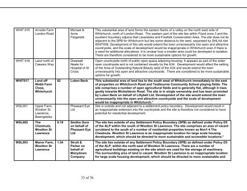
WHIT 015WHIT 016WHIT017WSL001WSL002WSL003Arnolds FarmLondon RoadL<strong>and</strong> north ofCaesars WayL<strong>and</strong> offWebb FarmClose,WhitchurchUpper Farm,Wootton StLawrence,<strong>Basingstoke</strong>TheChestnuts,Wootton StLawrenceManor Farm,Wootton StLawrenceMichael &AnneFitzgeraldDreweattNeate forHospital of StCrossThis substantial area of l<strong>and</strong> forms the eastern flanks of a valley on the north west side ofWhitchurch, north of London Road. The western part of the site lies within Flood zone 3 <strong>and</strong> thesouthern boundary adjoins that Laverstoke <strong>and</strong> Freefolk Conservation Area. The site does not lieadjacent to the SPB for Whitchurch but lies some distance to the west, separated by <strong>SHLAA</strong> siteWHIT008. Development of this site would extend the town unnecessarily into open <strong>and</strong> attractivecountryside, <strong>and</strong> the scale of development would be inappropriate in Whitchurch even if there isa need for additional allocations. It is unclear how a smaller area could be developed in isolation.There are therefore considered to be more sustainable options for growth.Open countryside north of public open space adjoining housing. It appears as part of the wideropen countryside <strong>and</strong> is not contained visually by the A34. Development would affect the settingof the Area of Outst<strong>and</strong>ing Natural Beauty west of the A34 <strong>and</strong> would extend the townunnecessarily into open <strong>and</strong> attractive countryside. There are considered to be more sustainableoptions for growth.82 Luken Beck This substantial area of l<strong>and</strong> lies to the south west of Whitchurch immediately to the eastof properties on Whitchurch Road <strong>and</strong> Testbourne Community School playing fields. Thesite comprises a number of open agricultural fields <strong>and</strong> is generally flat, although it risesgently towards Micheldever Road. The site is in single ownership <strong>and</strong> has been promotedby Luken Beck on behalf of Lillybell Ltd. Development of the site would extend the townunnecessarily into the open <strong>and</strong> attractive countryside <strong>and</strong> the scale of developmentwould be inappropriate in Whitchurch.*Pheasant EyeLtd0.19 Smiths Goreon behalf ofPheasant EyeLtd1.54 Strutt &Parker onbehalf ofManydownCompanySite is outside <strong>and</strong> not adjacent to a settlement policy boundary. Development would result inan inappropriate extension into the countryside <strong>and</strong> the site is therefore not considered to havepotential for residential development.The site lies outside of any Settlement Policy Boundary (SPB) as defined under Policy D5of the ALP within the south of Wootton St Lawrence. The site comprises an area of vacantscrubl<strong>and</strong> to the south of a number of residential properties known as Nos1-4 TheChestnuts. Wootton St Lawrence is an inappropriate location for large scale housingdevelopment, which should be directed to more sustainable <strong>and</strong> accessible locations.*The site lies outside of any Settlement Policy Boundary (SPB) as defined under Policy D5of the ALP, within the north east of Wootton St Lawrence. There are a number ofagricultural buildings existing on the site which are used for the storage of machinery.The surrounding area of l<strong>and</strong> is vacant. Wootton St Lawrence is an inappropriate locationfor large scale housing development, which should be directed to more sustainable <strong>and</strong>33 of 36


