

SHLAA _version 6_ - 2011 Update Document - Basingstoke and ...
SHLAA _version 6_ - 2011 Update Document - Basingstoke and ...
SHLAA _version 6_ - 2011 Update Document - Basingstoke and ...

Create successful ePaper yourself
Turn your PDF publications into a flip-book with our unique Google optimized e-Paper software.
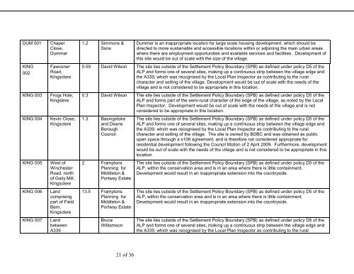
DUM 001ChapelClose,Dummer1.2 Simmons &SonsDummer is an inappropriate location for large scale housing development, which should bedirected to more sustainable <strong>and</strong> accessible locations within or adjoining the main urban areaswhere there are employment opportunities <strong>and</strong> available services <strong>and</strong> facilities. Development ofthis site would be out of scale with the size of the village.KING002KING 003FawconerRoad,KingsclereFrogs Hole,Kingslere0.59 David Wilson The site lies outside of the Settlement Policy Boundary (SPB) as defined under policy D5 of theALP <strong>and</strong> forms one of several sites, making up a continuous strip between the village edge <strong>and</strong>the A339, which was recognised by the Local Plan Inspector as contributing to the ruralcharacter <strong>and</strong> setting of the village. Development would be out of scale with the needs of thevillage <strong>and</strong> is not considered to be appropriate in this location.0.3 David Wilson The site lies outside of the Settlement Policy Boundary (SPB) as defined under policy D5 of theALP <strong>and</strong> forms part of the semi-rural character of the edge of the village, as noted by the LocalPlan Inspector. Development would be out of scale with the needs of the village <strong>and</strong> is notconsidered to be appropriate in this location.KING 004Kevin Close,Kingsclere1.3 <strong>Basingstoke</strong><strong>and</strong> DeaneBoroughCouncilThe site lies outside of the Settlement Policy Boundary (SPB) as defined under policy D5 of theALP <strong>and</strong> forms one of several sites, making up a continuous strip between the village edge <strong>and</strong>the A339, which was recognised by the Local Plan Inspector as contributing to the ruralcharacter <strong>and</strong> setting of the village. The site is owned by BDBC <strong>and</strong> was obtained as publicopen space through a s106 agreement, <strong>and</strong> is therefore not considered appropriate forresidential development following the Council Motion of 2 April 2009. Furthermore, developmentwould be out of scale with the needs of the village <strong>and</strong> is not considered to be appropriate in thislocation.KING 005West ofWinchesterRoad, northof Gaily Mill,Kingsclere2 FramptonsPlanning forMiddleton &Portway EstateThe site lies outside of the Settlement Policy Boundary (SPB) as defined under policy D5 of theALP, within the conservation area <strong>and</strong> is in an area where there is little containment.Development would result in an inappropriate extension into the countryside.KING 006L<strong>and</strong>comprisingpart of FieldBarn,Kingsclere13.5 FramptonsPlanning forMiddleton &Portway EstateThe site lies outside of the Settlement Policy Boundary (SPB) as defined under policy D5 of theALP, within the conservation area <strong>and</strong> is in an area where there is little containment.Development would result in an inappropriate extension into the countryside.KING 007L<strong>and</strong>betweenA339BruceWilliamsonThe site lies outside of the Settlement Policy Boundary (SPB) as defined under policy D5 of theALP <strong>and</strong> forms one of several sites, making up a continuous strip between the village edge <strong>and</strong>the A339, which was recognised by the Local Plan Inspector as contributing to the rural21 of 36


