

8164 Newnham 0704.indd - Basingstoke and Deane Borough Council
8164 Newnham 0704.indd - Basingstoke and Deane Borough Council
8164 Newnham 0704.indd - Basingstoke and Deane Borough Council

Create successful ePaper yourself
Turn your PDF publications into a flip-book with our unique Google optimized e-Paper software.
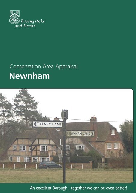
Conservation Area AppraisalConservation Area Appraisal<strong>Newnham</strong>An excellent <strong>Borough</strong> - together we can be even <strong>Newnham</strong> better!
Conservation Area AppraisalIntroductionThe <strong>Newnham</strong> Conservation Area was designated in 1981 <strong>and</strong> amendedin 1984 by Hampshire County <strong>Council</strong> in association with <strong>Basingstoke</strong><strong>and</strong> <strong>Deane</strong> <strong>Borough</strong> <strong>Council</strong>, in recognition of the special architectural<strong>and</strong> historic interest of the village.Having designated the Conservation Area, the Local Authority has astatutory duty to ensure that those elements that form its particularcharacter or appearance should be preserved or enhanced, especiallywhen considering planning applications.It is therefore necessary to define <strong>and</strong> analyse those qualities or elementsthat contribute to, or detract from, the special interest of the area <strong>and</strong>to assess how they combine to justify its designation as a ConservationArea. Such factors include:• its historic development;• the contribution of individual or groups of buildings tothe streetscape, the spaces that surround them <strong>and</strong>;• the relationship of the built environment with thenatural l<strong>and</strong>scape.They can also include the less tangible senses <strong>and</strong> experiences, such asnoise or smells, which can nevertheless play a key part in forming thedistinctive character of an area.The Appraisal takes the form of written text <strong>and</strong> an Appraisal plan. Inboth respects every effort has been made to include or analyse thoseelements key to the special character of the area. Where buildings,structures or features have not been specifically highlighted it doesnot necessarily follow that they are of no visual or historic value to theConservation Area. The document is intended to be an overall framework<strong>and</strong> guide within which decisions can be made on a site-specific basis.This document was adopted as Supplementary Planning Guidance bythe <strong>Borough</strong> of <strong>Basingstoke</strong> <strong>and</strong> <strong>Deane</strong> on 19th February 2004 <strong>and</strong>complements the policies of the <strong>Borough</strong> Local Plan (review).This document was subject to consultation with <strong>Council</strong>lors, Parish<strong>Council</strong>s <strong>and</strong> local amenity groups. A full list of consultees, copies oftheir responses, <strong>and</strong> details of the <strong>Council</strong>’s consideration of the issuesraised during the consultation period are available for inspection, byappointment, at the Planning, Environment <strong>and</strong> Transport Department,during normal office hours.2<strong>Newnham</strong>
Conservation Area AppraisalLocation <strong>and</strong> PopulationThe village of <strong>Newnham</strong> lies on a ridge of high ground to the east of theRiver Lyde <strong>and</strong> north of the main A30, between Old Basing <strong>and</strong> Hook.The 12th century village church, the highest point in the village, st<strong>and</strong>s99 metres above sea level. Superficial drift deposits of gravel overlayLondon clay, providing a ‘soak away’ effect before water is eventuallyretained by the clay-sub surface. This provides fertile l<strong>and</strong> <strong>and</strong>, despite itslocation away from the river. <strong>Newnham</strong> has always had access to water.Wells are features of every dwelling, or pairs of dwellings, built before1916 when mains water was piped into the community.<strong>Newnham</strong> is a localised high point within a l<strong>and</strong>scape typified bywoodl<strong>and</strong> <strong>and</strong> mixed farml<strong>and</strong> in undulating countryside. A ridge runsthrough Tylney Lane, <strong>Newnham</strong> Green, the Church <strong>and</strong> <strong>Newnham</strong> Hill.L<strong>and</strong> to the east of this ridge drains into the river Whitewater <strong>and</strong> l<strong>and</strong> tothe West drains into the Lyde <strong>and</strong> on to the Loddon.<strong>Newnham</strong> GreenHistoric DevelopmentSettlement Origins<strong>Newnham</strong> meaning ‘new estate’, is a long established community, withits first written reference dating from 1130. Two Neolithic h<strong>and</strong> axes havebeen discovered in the area, one at what is now Naishes Farm. But noevidence exists to tell us what form of settlement existed here beforethe 12th century. However, it is known that the church was in existencebetween 1125 <strong>and</strong> 1135 <strong>and</strong>, therefore, the community was establishedbefore this time.Pond at Tylney LaneSettlement Development<strong>Newnham</strong> provided a stopping place for drovers of livestock to rest <strong>and</strong>water at the village ponds, on the route to <strong>Basingstoke</strong> market. Duringthe 15th century the trading route from London to L<strong>and</strong>’s End, via<strong>Basingstoke</strong> <strong>and</strong> Salisbury, was established. It passed through <strong>Newnham</strong>,adding to its importance <strong>and</strong> sustaining its economy. However, in thelater 18th century the route of this road was changed, taking a linesimilar to that of the present A30. This change <strong>and</strong> the more recentconstruction of the M3, have combined to make <strong>Newnham</strong> the quietbackwater which it is today. The sub group known as The Barracks usedto be more directly part of the main village centred on <strong>Newnham</strong> Green,but the coming of the railway in 1838 isolated these dwellings. However,they continue to be an extension of the Conservation Area.<strong>Newnham</strong> 3
Conservation Area AppraisalAn Appraisal of the Conservation AreaAn OverviewView of Naishes FarmThe Appraisal plan identifies those buildings, views <strong>and</strong> key featuresthat are considered as essential to the special character or appearanceof the Conservation Area. In addition to the listed buildings, it alsoincludes unlisted buildings of particular individual or group value, whichare indicated on the Appraisal plan as notable. This is not to underminethe value of other unmarked buildings or structures that reflect thehistoric development of the village without detracting from its specialqualities. Individual hedgerows have not been included on the Appraisalplan. However, their contribution to the character of the ConservationArea cannot be underestimated, <strong>and</strong> their significance is implicit in theAppraisal.Built FormManor Farm HouseThe pattern of development is of scattered dwellings, clustered looselyaround the village green <strong>and</strong> along the lanes leading to the centre of thevillage. Exceptions to these are the more modern houses, constructed ina linear development along <strong>Newnham</strong> Road leading towards Hook, inKingsbridge Copse, <strong>and</strong> the small cluster of dwellings at The Barracks,south of the railway line. The latter are built around a small green.Key Individual BuildingsThere are 14 listed buildings in the <strong>Newnham</strong> Conservation Area,including a listed milestone on Crown Lane.Church of St NicholasThe Church of St Nicholas, the oldest surviving building in the village,dates from the 12th Century. A Norman chancel arch survives but theNorman aisles, nave <strong>and</strong> chancel have all been refaced. The tower is alater addition, along with the lych-gate, which was added in 1910. Thechurch is constructed in flint with stone dressings <strong>and</strong>, although it wasrebuilt in 1847, the original foundations remain.Manor Farmhouse is a Grade II listed two-storey dwelling, with a timberframedcore, <strong>and</strong> dates from the 16th <strong>and</strong> 17th centuries with lateralterations. Constructed of red brick in Flemish <strong>and</strong> English bonds, thefarmhouse has a long east front with a tile hung gable to the right.The south front is treble gabled with the central gable over-sailing onbrackets. A modern extension has been added to the west under atiled roof. The associated granary <strong>and</strong> barn are also Grade II listed. Thegranary dating from the early 19th century, is a small timber-framed4<strong>Newnham</strong>
Conservation Area Appraisalbuilding resting on nine staddle stones. The barn ten yards east ofthe farmhouse, dates from the 18th century. It is also timber-framed,retaining some queen post trusses, <strong>and</strong> includes a brick kennel outshot tothe south.Manor Farm Cottage, overlooking the village green, demonstrateschanging architectural fashion, with parts of the building dating from the17th, 18th <strong>and</strong> 19th centuries. This red brick <strong>and</strong> tiled property is of one<strong>and</strong> a half storeys, but has a two-storey cross wing. Some of the 17thcentury timber framing is still evident, along with some of the originalbrickwork. This building was originally two cottages.<strong>Newnham</strong> Green Farm, next to the principal village pond, also has aprominent position in the villagescape. The farmhouse dates from the17th <strong>and</strong> 18th centuries with modern alterations – namely the PVCwindows. This Grade II listed building has a near symmetrical front offive bays <strong>and</strong> is constructed in vitreous brick, with red dressings <strong>and</strong>blue headers. To the rear are an 18th century cottage (which was oncea cowshed), <strong>and</strong> a timber barn. For planning purposes these curtilagestructures are protected as if they are also listed.Manor Farm CottageElm Cottage is part of an important group of historic propertiesbordering the village green. Dating from the 18th century with modernalterations, this one storey <strong>and</strong> attic cottage is of red brick, with a tiledroof. Some earlier features of the listed building include the side <strong>and</strong> rearelevations which have exposed timber framing with painted brick infillpanels. Also at the village green is a Grade II listed milestone dating from1824.Elm Cottage<strong>Newnham</strong> House (formerly The Rectory) in Ridge Lane contrasts with theolder properties along the edge of the green, because of its substantialmass <strong>and</strong> obvious status. It dates from the early 19th century, <strong>and</strong> istypical of the Regency style of that period. The property has a five bayfront with painted stucco clad walls, a flanking porch with plain pilastersat corners, <strong>and</strong> a hipped slate roof. The building may incorporate parts ofan earlier building which is shown on the 1774 Tylney Estate Map.Tylney LodgeFurther along Ridge Lane, at the edge of the Conservation Areaboundary, <strong>and</strong> surrounded by open fields, is Tylney Lodge (listed as WestLodge). Constructed in 1899-1901 in red brick with stone dressings <strong>and</strong>a plain tiled roof, this building was listed in 1996. The listing includes thefour b<strong>and</strong>ed red brick <strong>and</strong> stone gate piers with stone pedestals.Tithe Barn is one of the most visually dominant properties in theConservation Area. It is notable in views across the village green <strong>and</strong>,because of its isolated position, retains its historic setting. The 17thcentury structure was originally called Hope Cottage <strong>and</strong> was neveractually a barn. The building has exposed timber framing, brick infillTithe Barn<strong>Newnham</strong> 5
Conservation Area Appraisalpanels <strong>and</strong> a half hipped clay tiled roof. Although the building wassubstantially altered <strong>and</strong> extended in the early 20th century, the original17th century central core survives. The adjacent timber building with tiled(originally thatched) roof is protected as a curtilage structure.Naishes BarnWoodside CottageNaishes Farm dates from the early 19th century <strong>and</strong> is also prominentin views across the village green. The group value of the Naishes Farmcomplex <strong>and</strong> with the Tithe Barn, is a key feature of the ConservationArea, <strong>and</strong> demonstrates the rural character of the village. The farmhouseis a two-storey symmetrical structure with red brick walling in Flemishbond, <strong>and</strong> painted stucco sections. It has a hipped slate roof with flateaves on cut brackets, <strong>and</strong> a later open porch with hipped tiled roof.The associated barn is also Grade II listed however, this is currently beingreviewed as the building was substantially rebuilt in 1995 following itscollapse during restoration works.On the south side of the railway line lies The Barracks, a detached part ofthe <strong>Newnham</strong> Conservation Area. A small green, part of the Common,is the setting for several interesting buildings. Holdings is a 17th centurylisted building st<strong>and</strong>ing next to Cromwells, formerly a terrace of smallcottages, now combined into a single dwelling. Both are half-timberedstructures with tile roofs. Adjacent to them st<strong>and</strong> Rose Farm Cottage,dating from about 1800, <strong>and</strong> the semi-detached Rose Cottage <strong>and</strong>Jasmine Cottage, built about 1880.Buildings of Local InterestThe Old House at Home PubOn the northern edge of the Conservation Area boundary are Woodside<strong>and</strong> Marionet House (formerly Bridleway). This pair of detached twostoreyrendered brick properties date from the 19th century. Woodsidehas a slate roof with a dentilled cornice, which enlivens the otherwiseplain façade. Marionet has a pantiled roof, <strong>and</strong> large casement windowsdominating the front elevation. Both properties have been altered <strong>and</strong>extended to suit 20th century living, but their original rectilinear form isstill apparent.Moving towards the village centre, <strong>Newnham</strong> Lodge is a much alteredVictorian property with modern additions. It is set back from the road, insubstantial grounds, <strong>and</strong> is partially screened from view by the roadsidehedgerow. This two-storey brick building has a slate roof <strong>and</strong> is renderedpink – a characteristic which is repeated at The Pink House <strong>and</strong> The OldHouse at Home pub.6<strong>Newnham</strong>
Conservation Area AppraisalSignificant Groups of BuildingsThe most significant group of buildings is located along the edge of thevillage green, where the original village core was established. This groupincludes the Grade II listed Elm Cottage, Apple Tree Cottage, Well <strong>and</strong>Quince Cottages, Home Cottage, <strong>and</strong> The Old House at Home publichouse.Group of local interest buildingsPublic <strong>and</strong> Private SpacesThe focus of the Conservation Area is the village green - a central openarea where all roads into the village converge. The green contains anumber of small ponds <strong>and</strong> is crossed by footpaths <strong>and</strong> tracks. ChurchPath leads off the green to the west in the direction of St Nicholas’Church, which is situated in a small churchyard encircled by trees.The green is a peaceful <strong>and</strong> tranquil area, which remains unspoiltby development, <strong>and</strong> a significant feature of the Conservation Area.However its appearance is marred by road signs, overhead cables <strong>and</strong>poles, creating an unnecessary sense of clutter.View across green to Elm CottageBuilding MaterialsMost of the buildings in the <strong>Newnham</strong> Conservation Area areconstructed in brickwork, <strong>and</strong> rendered white. On some of the olderproperties, dating from the 17th <strong>and</strong> 18th centuries, timber framingis visible, with brick nogged infill panels in places. Roofs are generallycovered with clay tiles, <strong>and</strong> many are hipped or half hipped, althoughslate is used in a few cases. Windows are generally timber casements<strong>and</strong>, although few original windows remain, the replacement windowsare mostly sympathetic to the character of the Conservation Area. Themajority of the outbuildings <strong>and</strong> agricultural buildings are clad withweatherboarding.8<strong>Newnham</strong>
Conservation Area AppraisalGreen Spaces, Trees, Spaces <strong>and</strong> otherNatural or Cultivated FeaturesThe village green is a key open space in the Conservation Area <strong>and</strong> thecentre-point of the historical development of <strong>Newnham</strong>. Most of thehistoric properties surround the village green <strong>and</strong> pond areas. The oldcoaching road originally ran along the west side of the green, linking<strong>Newnham</strong> to Hook.The wildflower meadow at the churchyard is being managed as a wildlifehaven, as part of the Living Churchyard Scheme. This national projectseeks to enhance wildlife <strong>and</strong> its habitat, as well as maximising theamenity value of churchyards <strong>and</strong> burial groundsTrees at CrossroadsThe Conservation Area benefits from many attractive views. At the edgesof the village, particularly to the west, some views extend over opencountryside. In contrast, the centre of the village is characterised by asense of enclosure, afforded by the significant tree belts. Views out ofthe Conservation Area on its eastern edges relate particularly to twoopen areas. Although these are not within the Conservation Area, theymake an important contribution to the character of the area.Approach roads into the village from the north, south <strong>and</strong> west are linedwith predominantly unmanaged hedges. Hedgerows, trees <strong>and</strong> blocks ofwoodl<strong>and</strong> are also prevalent <strong>and</strong> all add to the leafy character of theseapproach roads.View from <strong>Newnham</strong> Green FarmThe Setting of the Conservation AreaThe elevated position of <strong>Newnham</strong> provides some outst<strong>and</strong>ing views ofthe surrounding countryside, particularly looking northwest, where viewsextend for many miles. The village centre is sheltered <strong>and</strong> enclosed bythe tree belts <strong>and</strong> hedgerows that surround it, contributing to its ruralcharacter.<strong>Newnham</strong> 9
Conservation Area AppraisalConservation Area Planning ControlsThe following controls apply within the Conservation Area in addition tonormal planning controls:• Conservation Area Consent is normally required for thedemolition of buildings or structures over a certain sizewithin a Conservation Area.• The <strong>Council</strong> must be given six weeks notice of anyintention to undertake works to, cut down or uprootany trees in the Conservation Area.• Planning applications which, in the opinion of the<strong>Borough</strong> <strong>Council</strong> would affect the special characterof the Conservation Area must be advertised <strong>and</strong>the opportunity given for public comment. This mayinclude proposals outside the Conservation Area whichnevertheless affect its setting.Statutory policies relating to Conservation Areas <strong>and</strong> Listed Buildingsare set out in the adopted <strong>Basingstoke</strong> <strong>and</strong> <strong>Deane</strong> <strong>Borough</strong> Local Plan.These policies reflect the statutory duty on the Local Planning Authorityto have regard for the preservation of historic buildings or their setting,<strong>and</strong> to promote the enhancement of areas designated as of specialinterest. These policies seek to ensure that particular regard will be paidto the scale, height, form, materials <strong>and</strong> detailing of proposals includingboundary treatments <strong>and</strong> other features of note. In order to considerthe implications of development <strong>and</strong> given the detail required, the<strong>Borough</strong> <strong>Council</strong> will normally require proposals within the ConservationArea to be submitted in the form of a full, <strong>and</strong> not outline, application.The <strong>Borough</strong> <strong>Council</strong>’s Conservation Officers are available for advice<strong>and</strong> information on all matters relating to development proposals in aConservation Area.GrantsThe <strong>Borough</strong> <strong>Council</strong> provides grants for various types of work. Theseinclude Historic Buildings Grants, Environment <strong>and</strong> Regeneration Grants,<strong>and</strong> Village <strong>and</strong> Community Hall Grants. Leaflets are available explainingthe purpose <strong>and</strong> criteria for each grant. Please contact the <strong>Council</strong> forfurther information on any grant.10<strong>Newnham</strong>
Conservation Area Appraisal<strong>Newnham</strong> 11
Conservation Area Appraisal<strong>Newnham</strong>An excellent <strong>Borough</strong> - together we can be even better!<strong>Basingstoke</strong> <strong>and</strong> <strong>Deane</strong> <strong>Borough</strong> <strong>Council</strong>Civic Offices London Road <strong>Basingstoke</strong> Hants RG21 4AHTelephone 01256 844844 Fax 01256 844706www.basingstoke.gov.uk <strong>8164</strong>-0704


