IPET Report 3 Vol VIII
IPET Report 3 Vol VIII
IPET Report 3 Vol VIII

You also want an ePaper? Increase the reach of your titles
YUMPU automatically turns print PDFs into web optimized ePapers that Google loves.
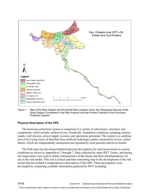
Figure 1. Map of the New Orleans and the South East Louisiana Area, the Geographic Bounds of the<br />
Study Region Considered in the Risk Analysis and the Primary Features of the Hurricane<br />
Protection System<br />
Physical Description of the HPS<br />
The hurricane protection system is comprised of a variety of subsystems, structures and<br />
components which include: earthen levees, floodwalls, foundation conditions, pumping stations,<br />
canals, wall closures, power supply systems, and operations personnel. The system is a combination<br />
of low-lying tracts of land that form artificial hydrologic entities enclosed by levees, called<br />
basins, which are independently maintained and operated by local parishes and levee boards.<br />
The Risk team has developed detailed physical descriptions for each basin based on current<br />
conditions as shown in Appendices 2 through 7. Data collected by other <strong>IPET</strong> Teams, and during<br />
site inspections were used to define characteristics of the basins and their interdependence for<br />
use in the risk model. This was a critical and time consuming step in the development of the risk<br />
model that has yielded a comprehensive description of the HPS. These descriptions were<br />
developed by examining available information gathered by <strong>IPET</strong> including:<br />
<strong>VIII</strong>-8 <strong>Vol</strong>ume <strong>VIII</strong> Engineering and Operational Risk and Reliability Analysis<br />
This is a preliminary report subject to revision; it does not contain final conclusions of the United States Army Corps of Engineers.