Dingee Reservoir Final Seismic Report - East Bay Municipal Utility ...
Dingee Reservoir Final Seismic Report - East Bay Municipal Utility ...
Dingee Reservoir Final Seismic Report - East Bay Municipal Utility ...
- No tags were found...

Create successful ePaper yourself
Turn your PDF publications into a flip-book with our unique Google optimized e-Paper software.
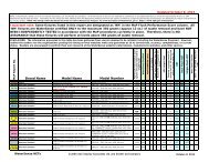
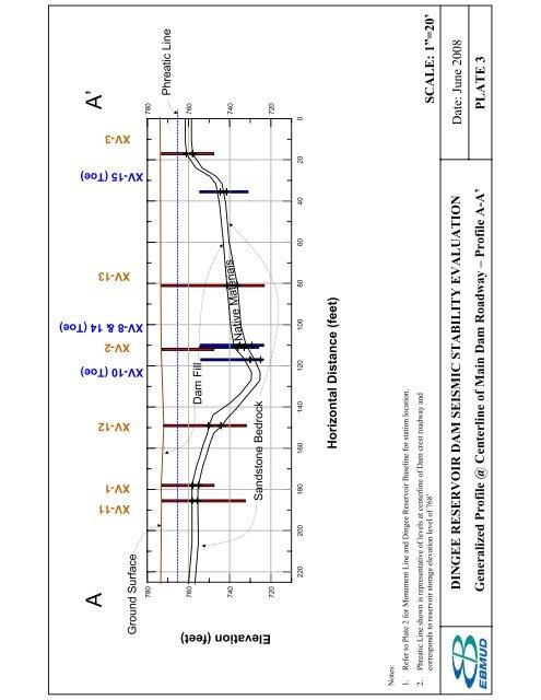
A A’<br />
780<br />
780<br />
760<br />
740<br />
720<br />
760<br />
740<br />
720<br />
Elevation (feet)<br />
XV-11<br />
XV-1<br />
XV-12<br />
XV-10 (Toe)<br />
XV-2<br />
XV-8 & 14 (Toe)<br />
XV-13<br />
XV-15 (Toe)<br />
XV-3<br />
Ground Surface<br />
Phreatic Line<br />
Native Materials<br />
Dam Fill<br />
Sandstone Bedrock<br />
220 200 180 160 140 120 100 80 60 40 20 0<br />
Horizontal Distance (feet)<br />
Notes:<br />
1. Refer to Plate 2 for Monument Line and <strong>Dingee</strong> <strong>Reservoir</strong> Baseline for station location.<br />
2. Phreatic Line shown is representative of levels at centerline of Dam crest roadway and<br />
corresponds to reservoir storage elevation level of 768’ SCALE: 1”=20’<br />
DINGEE RESERVOIR DAM SEISMIC STABILITY EVALUATION<br />
Generalized Profile @ Centerline of Main Dam Roadway –Profile A-A’<br />
Date: June 2008<br />
PLATE 3