BEN SCHOEMAN DOCK BERTH DEEPENING Specialist ... - Transnet
BEN SCHOEMAN DOCK BERTH DEEPENING Specialist ... - Transnet
BEN SCHOEMAN DOCK BERTH DEEPENING Specialist ... - Transnet

Create successful ePaper yourself
Turn your PDF publications into a flip-book with our unique Google optimized e-Paper software.
o<br />
o<br />
possibility of the dredge spoil discharge and/or the dredge spoil discharge<br />
activities exerting deleterious environmental affects at these sites, and<br />
Water depths in the candidate sites should be sufficient to allow a large degree of<br />
containment of discharged dredge spoil within the site boundaries, and<br />
There should be minimal constraint to environmental monitoring.<br />
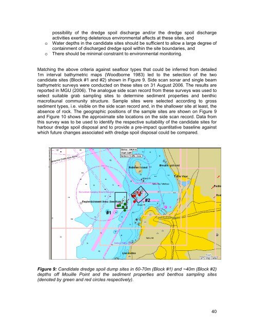
Matching the above criteria against seafloor types that could be inferred from detailed<br />
1m interval bathymetric maps (Woodborne 1983) led to the selection of the two<br />
candidate sites (Block #1 and #2) shown in Figure 9. Side scan sonar and single beam<br />
bathymetric surveys were conducted on these sites on 31 August 2006. The results are<br />
reported in MGU (2006). The analogue side scan record from these surveys was used to<br />
select suitable grab sampling sites to determine sediment properties and benthic<br />
macrofaunal community structure. Sample sites were selected according to gross<br />
sediment types, i.e. visible on the side scan record and, in the shallower site at least, the<br />
absence of rock. The geographic positions of the sample sites are shown on Figure 9<br />
and Figure 10 shows the approximate site locations on the side scan record. Data from<br />
this survey was to be used to identify the respective suitability of the candidate sites for<br />
harbour dredge spoil disposal and to provide a pre-impact quantitative baseline against<br />
which future changes associated with dredge spoil disposal could be compared.<br />
#2<br />
#1<br />
Figure 9: Candidate dredge spoil dump sites in 60-70m (Block #1) and ~40m (Block #2)<br />
depths off Mouille Point and the sediment properties and benthos sampling sites<br />
(denoted by green and red circles respectively).<br />
40