Journal of Applied Science Studies - Ozean Publications
Journal of Applied Science Studies - Ozean Publications
Journal of Applied Science Studies - Ozean Publications

You also want an ePaper? Increase the reach of your titles
YUMPU automatically turns print PDFs into web optimized ePapers that Google loves.
<strong>Ozean</strong> <strong>Journal</strong> <strong>of</strong> <strong>Applied</strong> <strong>Science</strong>s 1(1), 2008<br />
<strong>Ozean</strong> <strong>Journal</strong> <strong>of</strong> <strong>Applied</strong> <strong>Science</strong>s 1(1), 2008<br />
ISSN 1943-2429<br />
© 2008 <strong>Ozean</strong> Publication<br />
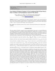
Analysis <strong>of</strong> Seismic Time-Depth Conversion Using Geostatistically- Derived Average<br />
Velocities over “Labod” Field, Niger Delta, Nigeria<br />
Olabode O. P. and Enikanselu P. A.<br />
Department <strong>of</strong> <strong>Applied</strong> Geophysics, Federal University <strong>of</strong> Technology, P.M.B. 704, Akure, Ondo State. Nigeria<br />
Email: paenikan@yahoo.com<br />
__________________________________________________________________________________________<br />
Abstract: Geostatistical techniques were used for seismic time-depth conversion over “Labod” field <strong>of</strong>fshore<br />
Western Niger Delta Basin with the aid <strong>of</strong> surface seismic and borehole data. Gamma ray and resistivity logs in<br />
four exploratory wells were utilized to delineate formation lithologies (facies) and formation fluid content. The<br />
target horizon B (top <strong>of</strong> sand 2) was selected for seismic structural mapping. Two major faults (F 1 , F 2 ) and three<br />
minor faults (F 3 , F 4 and F 5 ) were identified and interpreted on the seismic sections. Average velocities were first<br />
calculated from sonic logs. Geostatistical techniques - Kriging with External Drift (KED) and Simple Kriging -<br />
were employed to generate average velocity models used to convert the target B seismic time surface to depth in<br />
and away from well locations and depth maps were generated. The results <strong>of</strong> maximum percentage deviation<br />
computed among field-observed and computed depths were lower than 5% suggesting that the average velocity<br />
values estimated away from wells were reliable and applicable especially in areas where there is scarcity <strong>of</strong> well<br />
information. The Kriging with External Drift (KED) technique is particularly recommended because <strong>of</strong> the<br />
higher accuracy and denser data coverage. Finally, the method is cost effective because only few wells are<br />
required to achieve the expected results.<br />
Keywords: Geostatistical; Facies; Horizons; Faults; Average velocity; Variogram; Kriging<br />
__________________________________________________________________________________________<br />
INTRODUCTION<br />
The primary geophysical seismic data is <strong>of</strong>ten recorded in time. However, meaningful interpretation needs be<br />
displayed in depth. The primary objective <strong>of</strong> geophysical seismic interpretation is to prepare contour seismic<br />
maps showing the two way time to a reflector as picked on the seismic sections. This time (isochron) map must<br />
be converted to depth (isodepth) map through the seismic time-depth conversion process. The depth conversion<br />
process is usually carried out using formation average velocity information derived from well data. Geostatistical<br />
techniques, Iyiola et al., (2000), have been used to improve seismic time-depth conversion, which resulted in a<br />
significant increase in reservoir volume above the oil water contact over the result obtained from common<br />
techniques.<br />
Geostatistics is the application <strong>of</strong> statistical estimation techniques to spatially correlate random variables for<br />
geological and geophysical applications, Sheriff (1999). Generally, as the distance between two data points<br />
increases, the similarity between the two measurements decreases, Chambers et al., (2000). The application <strong>of</strong><br />
geostatistics in estimating accurate velocities for proper depth conversion <strong>of</strong> the reservoir is necessary to<br />
accurately estimate reserves and optimize the placement <strong>of</strong> development wells.<br />
However, velocity information derived from the existing wells is spatially too sparse to adequately delineate the<br />
lateral velocity variations, Hwang and McCorkindale (1994). Hence, seismic time to depth conversion is usually<br />
problematic due to the larger number <strong>of</strong> variables that influence the velocities. These variables - porosity,<br />
compaction, under compaction, e.t.c.- make it difficult to derive the correct velocity information and<br />
corresponding depth structure. Since a unique velocity solution is presumed inadequate, a probabilistic model <strong>of</strong><br />
the velocity may be realistic. To build such a model, we need to make sure that it incorporates geologically<br />
feasible lateral and vertical velocity variations and all available well information.<br />
This work analyses two other schemes – statistical regression <strong>of</strong> seismic time and average velocity and the<br />
Kriging technique and compares them with the conventional borehole (sonic) model <strong>of</strong> average velocity<br />
estimation. These methods have the advantage <strong>of</strong> largely improving spatial data density and extrapolating<br />
velocities between and away from borehole locations.<br />
79